Undergraduates Arrive in California for NASA Airborne Science Research Mission

OnSunday June 9, thirty-two undergraduate students from across the United States willarrive in California for the fifth annual Student Airborne Research Program(SARP). The thirty-two students hail from thirty-two colleges and universities in twenty-two states andPuerto Rico.

The majors of the students in thisinterdisciplinary group cover a wide range of scientific, mathematical, andengineering disciplines.   Students were competitively selected based ontheir outstanding academic performance, future career plans, ability to work inteams, and interest in Earth system science.  One of the great strengthsof SARP is that students from different disciplines learn from each other andwork together toward common research goals.  Students also form lastingpersonal and professional relationships that they will carry into their futurecareers. 

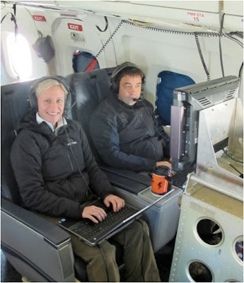
Thefirst two weeks of the program will take place at the Dryden Aircraft OperationsFacility (DAOF), where students will be introduced to NASA’s Earth Scienceresearch programs by NASA scientists, engineers, and program managers and by universityfaculty members.  Students will then flyonboard NASA’s DC-8 airborne laboratory where they will measure pollution andair-quality in the Los Angeles basin and in California’s Central Valley, anduse remote sensing instruments to study forest ecology in the Sierra NevadaMountains and ocean biology along the California coast. In addition to airbornedata collection, students will take measurements at field sites.


Thefinal six weeks of the program will take place at the University of California,Irvine where students will analyze and interpret the data they collectedonboard the aircraft.  At the conclusionof the program, each student will deliver a final presentation on his/herresults and conclusions.  Many studentsin the past have gone on to present their research at conferences such as theAmerican Geophysical Union Fall Meeting in San Francisco.


Forfrequent updates on the program throughout the summer, check out the NASA SARPblog at

https://blogs.nasa.gov/cm/blog/SARP


Over 3000 K-12 Students Connected with NASA Airborne Science Program Missions During the 2012-2013 School Year

One hundred and sixty-four K-12 classrooms from across the UnitedStates and Chile with 3030 total students participated in online chats withAirborne Science Program mission personnel in the field during the 2012/2013school year. 

Mission Tools Suite for Education is a unique website that allows studentsand teachers to connect directly with ongoing Airborne Science researchcampaigns.  The Mission Tools Suite (MTS) is web-based software used bymission personnel to monitor and assist with real-time decision making duringthe course of an Airborne Science mission.  The Airborne Science Programhas created a scaled down version of the tool called MTS for Education (MTSE),which is aimed at supporting core K-12 classroom science curriculum.


The NASA Airborne Science Program’s Mission Tools Suite for Educationwebsite allows K-12 classrooms from around the world to track the locations ofNASA aircraft in real-time and participate in live text-chats with missionscientists, pilots, and others flying inside the airplanes and with missionpersonnel on the ground.  Websitefeatures include:

      Live flight following 

     Students and teachers can track the position ofASP aircraft on a map in real-time

      Live camera feeds from the aircraft (on selectmissions)

      Real-time satellite data products

     Overlay current weather, hurricane tracks, etc

      Environmental data from the aircraft

     Ability to plot aircraft altitude, speed,temperature, wind speed, etc. in real-time

      Live text chats between classrooms and missionscientists, pilots, and others onboard the aircraft or on the ground

The website has so far been used during five NASA Airborne ScienceProgram missions in 2012-2013

      Hurricane and Severe Storm Sentinel (Sept 2012)

      IceBridge Antarctic (Oct-Nov 2012)

      DISCOVER-AQ (Jan-Feb 2013)

      ATTREX (Feb-Mar 2013)

      IceBridge Arctic (Mar-May 2013)

From Kindergarteners asking if IceBridge personnel saw Santa when theyflew over the North Pole (they did not), to middle school students asking what itfeels like to fly a Global Hawk over a hurricane without actually being inside it during HS3, to highschool students asking specific questionsabout atmospheric chemistry during DISCOVER-AQ and ATTREX, classroom chats are effective at all grade levels.

IceBridge Project Manager, Christy Hansen and Project Scientist, Michael Studinger onboard the DC-8 flying over Antarctica chatting with a middle school classroom in Maryland.


“Our 3rd graders were enthralled with following Operation IceBridge.They loved learning about the science of the mission from those on theairplane, and were fascinated with Antarctica, and learned a lot about iceshelves, glaciers, and much more. Over the course of the year, they study allthe continents, so the area covered by the flights gave them an opportunity tobe introduced to Google Earth and use it to explore South America andAntarctica.  Kudos to Operation Icebridgefor including students in their mission. Thanks to all involved.”

–Cameron Cross, 3rdGrade Teacher, New Hampshire


Watch our educational video about the HS3 mission to seewhat MTSE looks like in action!

For more information and to connect your classroom with NASAAirborne Science missions all over the world, email Dr. Emily Schaller (emily.schaller(at)nasa.gov)

Teachers Learn About Airborne Science

Twenty-seven elementary, middle, and high school teachers from Los Angeles and Kern counties visited the NASA Dryden Aircraft Operations Facility (DAOF) in Palmdale, California on Friday January 25, 2013.  The visit coincided with the NASA Airborne Science Media Day.

The K-12 teachers toured insides of the NASA DC-8 and P-3B Airborne Science laboratories.  In addition, they saw and learned about the current missions of the NASA ER-2, G-III and B-200 aircraft. 


NASA DC-8 Mission Manager, Frank Cutler, talks to teachers visiting the NASA Dryden Aircraft Operations Facility (Image Credit: NASA/Tom Tschida)


Frank Cutler talks to teachers inside the NASA DC-8 (Image Credit: NASA/Tom Tschida)


Teachers board the NASA P-3B (Image Credit: NASA/Tom Tschida)


Randy Albertson, NASA Airborne Science Program Deputy Director talks to K-12 teachers (Image Credit: NASA/Tom Tschida)

NASA Airborne Science Program deputy director, Randy Albertson, gave the teachers an overview of NASA’s fleet of airplanes and how NASA uses these planes to study the Earth and its atmosphere. Teachers also learned about how they could follow Airborne Science flights and chat live with NASA scientists directly from their classrooms through a specialized website (contact emily.schaller@nasa.gov for more information).  Finally, teachers also learned about teacher workshops and other opportunities available to them through the AERO Institute.


HS3 Mission Documentary

Hurricane and Severe Storm Sentinel Mission Documentary

The Hurricane and Severe Storm Sentinel, or HS3, mission will overflytropical storms and hurricanes using NASA’s Global Hawk UnmannedAircraft Systems (UAS) in the Northern Atlantic, Caribbean, and Gulf ofMexico. These flights will improve our understanding of the processesthat lead to the development of intense hurricanes. The mission willtake place for one-month periods during the 2012, 2013, and 2014Atlantic Basin hurricane seasons.

HS3 will use two of NASA’sGlobal Hawks, each equipped with state-of-the-art science instruments.One aircraft will monitor the environment around storms to look forconditions favorable for storm formation and intensification. The otheraircraft will repeatedly fly directly over storms to collect data on theinner-core structures that lead to storm intensity change.

TheGlobal Hawk is a robotic plane that can fly to an altitude of 19.8 km(12.3 miles)—roughly twice as high as a commercial airliner—as far as20,278 km (12,600 miles), and for as long as 28 hours. The Global Hawksprovide a new and unique capability for collecting continuous,high-resolution measurements that will be crucial to understandingrapidly evolving processes in hurricanes.

To learn more about HS3, visit: www.NASA.gov/HS3

Students present results of SARP 2012 research at American Geophysical Union Fall Meeting

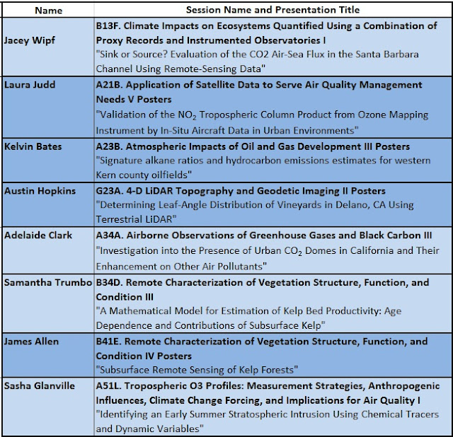
Eight NASA Student Airborne Research Program (SARP) 2012 participants presented talks or posters on their summer research at the American Geophysical Union (AGU) Fall Meeting in San Francisco, CA December 3-7, 2012.

At the conclusion of SARP in August 2012, the eight students each submitted first-author abstracts to AGU with their faculty advisors and mentors as coauthors.  Students submitted abstracts to atmospheric science, biogeoscience, and geodesy sessions (listed below).  


SARP 2012 participants Laura Judd, Kelvin Bates, Austin Hopkins and James Allen present their posters at AGU

In addition to the eight SARP 2012 students who presented their summer research, eight additional SARP alumni (2009-2012) also presented at the meeting.  On Thursday December 6th, SARP alumni, mentors, faculty, staff, speakers, and NASA managers all gathered for a reunion dinner at Chevy’s Fresh Mexican Restaurant in San Francisco.


SARP Alumni, mentors, faculty and others at the reunion dinner


The NASA booth at AGU was also the location for the debut of the 2012 SARP video.


Applications are now being accepted for SARP 2013.
Apply here:
www.nserc.und.edu/learning/SARP2013.html

Help spread the word about this amazing experience!

NASA Airborne Science Missions Connect with Classrooms

During NASA’s Hurricane and Severe Storm Sentinel (HS3) mission, students and teachers from across the United States learned about hurricanes and the NASA airplane that was studying them.


NASA’s Global Hawk lifts off the runway at NASA’s Wallops Flight Facility, Wallops Island, Va. on Sept. 19, 2012. The Global Hawk took off to investigate Tropical Storm Nadine as part of the Hurricane and Severe Storm Sentinel (HS3) mission. Credit: NASA Wallops

HS3 is a five-year NASA mission to study hurricane formation and evolution with NASA’s Global Hawk Unmanned Aerial Vehicles (UAV).

http://nasa.gov/hs3

During the Global Hawk flights, students and teachers from across the United States were able to chat live with NASA scientists, weather forecasters, and pilots while tracking the position of the Global Hawk and the locations of hurricanes in real time.


Students and teachers tracked the location of the Global Hawk and Atlantic hurricanes in real-time.


Though the HS3 mission has concluded for this year, many of these classrooms are continuing their involvement in Airborne Science Program missions. 

Next up is NASA’s Operation IceBridge. 

http://nasa.gov/icebridge

During IceBridge flights, students and teachers will be able to track the position of the DC-8 and chat live with scientists and crew who are actually onboard the DC-8 flying over Antarctica.


Looking out the window of NASA’s DC-8 during its transit flight to Chile for Operation IceBridge.(Credit: NASA/Jim Yungel)


For more information and to get your classroom involved in NASA Airborne Science missions, please contact emily.schaller(at)nasa.gov

Students Present Airborne Science Research at AGU

Six students from the 2011 NASA Student Airborne ResearchProgram (SARP) will present the results of their summer research at the 2011American Geophysical Union (AGU) Fall Meeting in San Francisco.  Thespecial session for the SARP presentations will take place at in the Exhibit Hall at the NASA booth on Wednesday, December 7 from 11:30 AM-1:00 PM.

Learn more about SARP by watching the 2011 video

Applications are now being accepted for SARP 2012.

Download the application here:

www.nserc.und.edu/learning/SARP2012.html

DISCOVER-AQ Mission Documentary

Jane Peterson/NSERC


DISCOVER-AQ is a multi-year air quality research campaign that stands for Deriving Information on Surface conditions from Column and Vertically Resolved Observations Relevant to Air Quality.


Two NASA research aircraft, the P-3B and UC-12, flew a series of profiles over six selected ground stations that monitor urban air quality in the Baltimore-Washington, DC area. 


Researchers chose the month of July to conduct the first DISCOVER-AQ mission, because that is when pollution peaks in the Baltimore-Washington area.


The data collected from the aircraft and ground sites will be used to assess how satellites interpret air quality near Earth’s surface. Satellites have difficulty distinguishing between pollution that is high in the atmosphere and pollution at Earth’s surface.

Future missions are planned in Houston, Sacramento, and the southeastern U.S. to compare the regional influences that drive air quality.

Methane Sounder Instrument Completes Successful Test Flights on the NASA DC-8

Last week, the NASA DC-8flew three flights over the California Central Valley to test the performanceof a laser-based instrument designed to measure methane in Earth’s atmosphere.   The Methane Sounder Instrument, built by Haris Riris and histeam from the Goddard Space Flight Center, may one day map methane from afuture Earth or Mars orbiting satellite.

On Earth, methane is animportant greenhouse gas produced by certain types of bacteria in soils and inthe digestive tracts of some animals. Large quantities of methane are alsoproduced as a result of forest fires and human industrial processes.  Knowledge of the global distributionand abundance of methane is important for understanding global climatechange. 

Methane has also been recentlydetected on Mars.  Because methaneis rapidly destroyed in Mars’ atmosphere, it must have been produced relativelyrecently.  While geologicalprocesses can produce methane, another exciting possibility is that Mars’ methane isproduced by life. Determining the abundance and locations of methane sources onMars is therefore extremely important for understanding recent geological (andperhaps biological) processes occurring on the Red Planet.

Before instruments areinstalled on satellites or spacecraft, many are first tested from NASAairplanes.  The Methane Sounder instrument team spent two weeks at the Dryden Aircraft Operations Facility inPalmdale, CA installing and testing their instrument on the NASA DC-8.  They spent several days aligning andtesting the instrument from the airplane on the ground before finally testingits performance on three flights over the California Central Valley.  

Methane Sounder instrument PI Haris Riris (left) and StewartWu (right) test the alignment of the laser underneath the DC-8 at the NASADryden Aircraft Operations Facility. Before flying their instrument on the DC-8, they fired its laser fromthe parked airplane toward the ground, reflected the laser off of a mirrorunderneath the airplane (above), and aimed at a nearby building.  The infrared laser is invisible to thehuman eye.

Inside the DC-8, while parked at the Dryden AircraftOperations Facility, Haris Riris (center) and Martha Dawsey (left) align thelaser for the Methane Sounder instrument. The laser is fired straight down through a port on the underside of theaircraft.  To test the alignment,it was reflected off of a mirror (see above) and then off of the side of a nearlybuilding.


The Methane Sounder Instrumentdetects methane with an infrared laser beam.  The laser emits light at a wavelength (color) that is toored for the human eye to detect (1.65 microns).  Thiswavelength corresponds to one of the wavelengths that the methane moleculeabsorbs light.  As the laser passes through the atmosphere and bounces off of theground, methane molecules in the atmosphere absorb some of the light from thelaser.  Measuring the amount of absorption that occurs as the instrument passesover different locations allows the team to build methane maps.

Although current Earth-orbitingsatellites have instruments that can detect and map Earth’s methane, the laser-basedsystem of the Methane Sounder will enable much higher accuracy methanedetections and higher resolution methane maps than are possible with currentnon-laser based instruments.  With somemodifications, the laser system could also be used for a Mars-orbiting satellite.

The NASA DC-8 early morning before takeoff for the MethaneSounder Instrument test flight on August 24, 2011.

To test the instrument, theteam flew at a variety of altitudes over a large methane source (a cattlefeedlot) in the California Central Valley.  

Flight track (in red) for August 24, 2011.  The DC-8 took off from Palmdale,California, flew northwest to the California Central Valley and flew in a largeracetrack pattern around a cattle feedlot.

Altitude profile of the DC-8 from August 24, 2011.  The DC-8 took off from Palmdale, flewat 10,000 feet toward the cattle feedlot and then increased in altitude in 5000-footincrements while flying in a racetrack pattern over the California CentralValley (see flight track map above).

Haris Riris (right) and his group from the Goddard SpaceFlight Center watch as they acquire data with the Methane Sounder Instrument onboardthe NASA DC-8.

Cattle feedlot near Coalinga, Central California seen from10,000 ft from the NASA DC-8.  Dueto the large number of cattle concentrated in such a small area, this feedlotis a large methane source.

The instrument performedoutstandingly well, detecting the presence of methane in the atmosphere at allaltitudes. “The Methane Sounder is the first demonstration of methane detectionusing lasers from an aircraft flying above 30,000 ft,” said Riris.  “It should be avaluable tool for monitoring greenhouse gas emissions, especially in theArctic.” 

The Methane Sounder instrument team is all smiles in flightonboard the DC-8 as their instrument performs well.

Funding for the MethaneSounder was provided by the NASA Astrobiology Science and Technology forInstrument Development program with support from the ASCENDS CO2 Instrument Incubator Program.