New data from NASA’s SDO (Solar Dynamics Observatory) is available at its regular frequency following a data outage in November 2024. A small amount of historical data collected prior to 2014 is still being restored from backups. The SDO mission provides critical, near-real-time and high-resolution solar observations for the study of the near-Earth space environment and space weather by tracking solar activity, magnetic fields, and the outer solar atmosphere.
Repairs were completed at the Joint Science Operations Center at Stanford University – which processes and distributes data from two of SDO’s imaging instruments – in February, restoring the flow of SDO data to its normal cadence.
Data from NASA’s IRIS (Interface Region Imaging Spectrograph) mission was also briefly impacted during the outage. As of February, all data is available from the IRIS archive at Lockheed Martin Solar & Astrophysics Lab.
Following a data outage in November 2024, some data from NASA’s SDO (Solar Dynamics Observatory) and full data from NASA’s IRIS (Interface Region Imaging Spectrograph) has been successfully restored. This marks a significant step in resuming the flow of critical solar observations informing scientists and the space weather community.
Repairs are ongoing at the Joint Science Operations Center at Stanford University, which processes and distributes data from two of SDO’s imaging instruments. Since early January, near-real time images from these instruments are being provided every 15 minutes. Additionally, processing of most other SDO data has resumed, with additional processed data being distributed as system repairs progress.
The SDO and IRIS missions continuously monitor solar activity, providing essential data to help scientists understand solar dynamics, such as flares, coronal mass ejections, and other space weather that can impact satellites, communications, and even power grids on Earth. No data was lost during the outage, which will allow researchers to analyze past solar activity once full data distribution is restored.
Some data from NASA’s SDO (Solar Dynamics Observatory) and IRIS (Interface Region Imaging Spectrograph) missions is temporarily unavailable because of flooding in the building that houses the missions’ data center at Stanford University. Both spacecraft remain healthy and are otherwise operating normally.
On Tuesday, Nov. 26, a broken pipe caused major flooding in the building that houses the Joint Science Operations Center, which processes and distributes data from two of SDO’s instruments and processes IRIS data. New data and some historical data from the affected instruments will be unavailable until repairs are complete, currently estimated for the first quarter of 2025. During the outage, both spacecraft continue to collect and downlink data. The mission teams expect this data to be available once repairs to the data center are complete.
The outage includes current and historical data for SDO’s Atmospheric Imaging Assembly and Helioseismic and Magnetic Imager instruments, which provide a constant eye on the Sun in multiple wavelengths of light. Some historical data from these instruments through Nov. 26 is available from alternative sources outlined on the Joint Science Operations Center website.
The outage also includes current data from the IRIS mission, which observes how solar material moves, gathers energy, and heats up as it travels through the Sun’s lower atmosphere. Historical processed data from this mission through Nov. 22 continues to be accessible from the IRIS archive at Lockheed Martin Solar & Astrophysics Lab.
Data from SDO’s Extreme ultraviolet Variability Experiment instrument is unaffected and remains available from the Laboratory for Atmospheric and Space Physics at the University of Colorado Boulder.
For more information, status updates on repairs, and alternate routes to access historical mission data, please visit the Joint Science Operations Center website.
NASA’s SunRISE mission — short for the Sun Radio Interferometer Space Experiment — passed a mission review on Sept. 8, 2021, moving the mission into its next phase.
“SunRISE will detect and study eruptions of radio waves from the Sun that often precede major solar events containing high energy particle radiation,” said Justin Kasper, SunRISE principal investigator at the University of Michigan in Ann Arbor. “Knowing when and how solar storms produce intense radiation will help us better prepare and protect our astronauts and technology.”
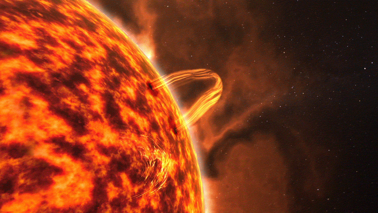
A coronal mass ejection erupts from the Sun and sends Type II radio bursts ahead of it. Credit: NASA
The review, Key Decision Point C, evaluated the mission’s preliminary design and project plan to achieve launch by its target launch readiness date. With the successful review, SunRISE now moves into Phase C, which includes the final design of the mission and fabrication of the spacecraft and instruments. The six spacecraft will then go through final assembly and testing before their launch readiness date of April 2024.
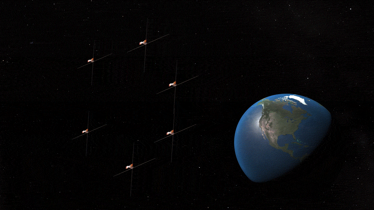
Consisting of six miniature solar-powered spacecraft known as CubeSats, the SunRISE constellation will operate together as one large telescope — forming the first space-based imaging low radio frequency interferometer — to create 3D maps pinpointing how giant bursts of energetic particles originate from the Sun and evolve as they expand outward into space. The mission will also map, for the first time, how the Sun’s magnetic field extends into interplanetary space — a key factor that drives where and how storms move throughout the solar system. Data from SunRISE will be collected and transmitted to Earth via NASA’s Deep Space Network. The six CubeSats will span roughly six miles across and fly slightly above geosynchronous orbit at 22,000 miles from Earth’s surface.
SunRISE measures radio bursts from solar events and transmits the data to NASA’s Deep Space Network. Credit: NASA
“The unique formation of the CubeSats gives us a detailed view of the Sun that will help us figure out how high energy particle radiation is initiated and accelerated near the Sun and how it affects interplanetary space,” said Joseph Lazio, SunRISE project scientist at NASA’s Jet Propulsion Laboratory. “Studying the radio waves that precede solar particle storms could potentially help us create an early warning system.”
SunRISE is a Mission of Opportunity under the Heliophysics Division of NASA’s Explorers Program Office. Missions of Opportunity are part of the Explorers Program, which is the oldest continuous NASA program designed to provide frequent, low-cost access to space using principal investigator-led space science investigations relevant to the Science Mission Directorate’s (SMD) astrophysics and heliophysics programs. The program is managed by NASA’s Goddard Space Flight Center in Greenbelt, Maryland, for SMD, which conducts a wide variety of research and scientific exploration programs for Earth studies, space weather, the solar system and universe.
SunRISE will be built by the Space Dynamics Laboratory at Utah State University and be a hosted payload on a commercial spacecraft provided by Maxar of Westminster, Colorado. Once in orbit, the host spacecraft will deploy the six SunRISE spacecraft, place the CubeSats into their orbits, and then continue its prime mission. SunRISE will launch no earlier than April 2024 and no later than September 2025 depending on the schedule of the commercial host spacecraft.
SunRISE is led by the University of Michigan in Ann Arbor and managed by NASA’s Jet Propulsion Laboratory in Southern California.
By Joy Ng NASA’s Goddard Space Flight Center, Greenbelt, Md.
From its vantage point in geostationary orbit, NASA’s GOLD mission – short for Global-scale Observations of the Limb and Disk – has given scientists a new view of dynamics in Earth’s upper atmosphere. Together, three research papers show different ways the upper atmosphere changes unexpectedly, even during relatively mild conditions that aren’t typically thought to trigger such events.
Extra electrons
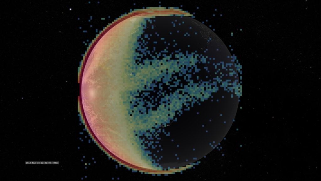
GOLD studies both neutral particles and those that have electric charge – collectively called the ionosphere – which, unlike neutral particles, are guided by electric and magnetic fields. At night, the ionosphere typically features twin bands of dense charged particles. But GOLD’s data revealed previously unseen structures in the nighttime ionosphere’s electrons, described in research published in the Journal of Geophysical Research: Space Physics on Aug. 24, 2020.
Data from NASA’s Global-scale Observations of the Limb and Disk, or GOLD, mission reveals the twin bands of charged particles that persist near the equator at night. Credit: NASA/GOLD/NASA’s Scientific Visualization Studio
While comparing GOLD’s data to maps created with ground-based sensors, scientists spotted a third dense pocket of electrons, in addition to the typical two electron bands near the magnetic equator. Reviewing GOLD data from throughout the mission, they found that the peak appeared several times in October and November of multiple years, suggesting that it might be a seasonal feature.
Though scientists don’t know what exactly creates this extra pocket of dense electrons, it appeared during a period of relatively mild space weather conditions. This was a surprise to scientists, given that big, unpredictable changes in the ionosphere are usually tied to higher levels of space weather activity.
Nitrogen drops
GOLD also saw large drops in the upper atmosphere’s oxygen-to-nitrogen ratio – a measurement typically linked to the electron changes that can cause GPS and radio signal disturbances.
This event was notable to scientists not for what happened, but when: The dips that GOLD saw happened during a relatively calm period in terms of space weather, even though scientists have long associated these events with intense space weather storms. The research was published on Sept. 9, 2020, in Geophysical Research Letters.
During a geomagnetic storm – space weather conditions that disturb Earth’s magnetosphere on a global scale – gases in the upper atmosphere at high latitudes can become heated. As a result, nitrogen-rich air from lower altitudes begins to rise and flow towards the poles. This also creates a wind towards the equator that carries this nitrogen-rich air down towards lower latitudes. Higher nitrogen in the upper atmosphere is linked to drops in electron density in the ionosphere, changing its electrical properties and potentially interfering with signals passing through the region. GOLD observed this effect several times during relatively calm space weather conditions during the day – outside of the disturbed conditions when scientists would normally expect this to happen.
These changes during seemingly calm conditions may point to a space weather system that’s more complicated than previously thought, responding to mild space environment conditions in bigger ways.
“The situation is more complex – the ionosphere is more structured and dynamic than we could have seen before,” said Dr. Sarah Jones, mission scientist for GOLD at NASA’s Goddard Space Flight Center in Greenbelt, Maryland.
Improving models
Indeed, GOLD’s observations of changing atmospheric composition are already informing scientists’ computer models of these processes. A paper published in Geophysical Research Letters on May 20, 2021, uses GOLD’s data as a reference to show how changes near the poles can influence the ionosphere’s conditions in the mid-latitudes, even during periods of calm space weather activity. GOLD’s broad, two-dimensional view was critical to the finding.
“When you look in two dimensions, a lot of things that look mysterious from one data point become very clear,” said Dr. Alan Burns, a researcher at the High Altitude Observatory in Boulder, Colorado, who worked on the studies.
By Sarah Frazier NASA’s Goddard Space Flight Center, Greenbelt, Md.
By Mara Johnson-Groh NASA’s Goddard Space Flight Center
Up in the night sky, above the auroras and below the Moon, there exists a heated superhighway. Instead of cars though, this transient highway funnels charged particles across hundreds of thousands of miles toward Earth for a few minutes before vanishing.
While we can’t see it with our eyes, scientists have recently discovered a new way to look at the entire transportation structure from afar for the first time using special particles called energetic neutral atoms. Ultimately, this could help scientists predict when dangerous effects of space weather might be headed towards Earth.
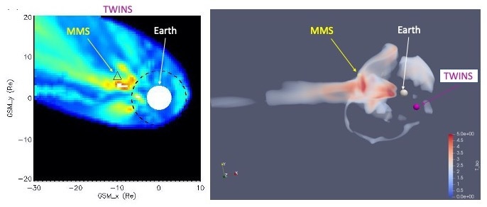
Using data from NASA’s MMS and TWINS missions, scientists were able to map temporary highways hurtling particles towards Earth during stormy space weather conditions. Credit: Amy Keesee/University of New Hampshire
The highway is temporarily created within Earth’s self-generated magnetic bubble, during periods of intense activity from the Sun, when the planet is bombarded with charged particles and radiation. The bubble protects the planet from most of the particles, but some sneak through and are funneled along towards Earth along a highway-like structure.
Since these particles can disrupt satellites and telecommunications in space and damage systems on Earth, scientists are keen to study how they are transported. However, charged particles have to be measured where they are – rather than being tracked with far-away observatories. This is like monitoring traffic by standing right on a highway instead of from a helicopter flying above – which makes it hard to get a full picture of the routes the vehicles travel.
As a result, scientists have only been able to glimpse snapshots of particles’ paths as satellites passed through the region.
But recently a group of scientists, led by Amy Keesee, a space physicist at the University of New Hampshire, decided to look at the highway in a new way. Using data from NASA’s Two Wide-angle Imaging Neutral-atom Spectrometers – TWINS – mission, which operated from 2008 to 2020, the scientists studied the region using energetic neutral atoms, or ENAs.
These particles are formed when a charged particle hits a neutral atom and loses its charge to the atom. Since it’s no longer charged, the particle is unbound from the magnetic fields it was previously confined to and goes streaming through space along a straight line. By measuring these particles, scientists can work back to see where the particle was created, providing an image of the region of charged particles. Scientists have previously used this technique to study the edge of the magnetic bubble created by the Sun.
Using near-Earth ENAs measured by TWINS, the scientists were able to create a complete map of the highway. They also verified their findings with data from NASA’s Magnetospheric Multiscale mission, which happened to fly through the region at the time. Together, this opens the door to observing these particle flows from far away, rather than needing to fly a spacecraft right through them. Such information could improve our real-time predictions of when charged particles are coming toward Earth.
By Mara Johnson-Groh NASA’s Goddard Space Flight Center
On January 31, 1958, the U.S. launched its first satellite: Explorer 1. Among its many achievements, Explorer 1 made the ground-breaking discovery of belts of charged particles encircling Earth.
That discovery is still being studied today. 63 years on, scientists are still learning about these belts – now known as the Van Allen belts – and their effects on Earth and technology in space.
From 2012 to 2019, scientists used NASA’s Van Allen Probes to gather data from the dynamic region discovered by Explorer 1. While the mission is no longer operational, it left a treasure-trove of observations, which are continuing to reveal new things about the belts. In 2020, over 100 scientific papers were published in peer-reviewed international journals using Van Allen Probes data, often leading studies in conjunction with partner missions. Here are three surprising discoveries scientists have recently made about the Van Allen belts.
1) In addition to particles, space is filled with electromagnetic waves called plasma waves, which affect how charged particles in space move. Near Earth, one type of wave, called whistler chorus waves, bounces back and forth following magnetic field lines between Earth’s North and South poles. Observations from the Van Allen Probes and Arase missions recently showed that these waves can leave the equator and reach higher latitudes where they permanently knock particles out of the Van Allen belts – sending the particles out into space never to return.
2) In addition to removing charged particles from the belts, magnetic activity can also add in new particles. Van Allen Probes observations combined with data from a Los Alamos National Lab geosynchronous satellite and one of NASA’s THEMIS satellites showed how hot charged particles can be abruptly transported by magnetic activity across 400,000 miles, from distant regions under the influence of Earth’s magnetic field into the heart of the Van Allen belts.
3) Earth’s magnetic environment and the Van Allen belts are highly influenced by the Sun, particularly when it releases clouds of ionized gas called plasma, which can create hazardous space weather. Some stormy activity from the Sun can create an intense ring of current surrounding Earth. Understanding these currents is critical for predicting their adverse space weather effects on ground-based infrastructure. Using years of Van Allen Probes data, scientists can now accurately model the distribution of the ring current around Earth even during the most intense space weather storms.
By Sarah Frazier NASA’s Goddard Space Flight Center
A special collection of research in the Journal of Geophysical Research: Space Physics highlights the initial accomplishments of NASA’s GOLD mission. GOLD, short for Global-scale Observations of the Limb and Disk, is an ultraviolet imaging spectrograph that observes Earth from its vantage point on a commercial communications satellite in geostationary orbit.
Since beginning science operations in October 2018, GOLD has kept a constant eye on Earth’s dynamic upper atmosphere, watching changes in the Western Hemisphere, marked by changes in the temperature, composition and density of the gases in this region.
A few highlights include:
Results on one source of airglow seen at night, which relies on electrons on Earth’s day side becoming ionized by sunlight, then being transported along magnetic field lines to the nightside, where they create visible airglow (Solomon, et al)
New evidence supporting the idea that the equatorial ionization anomaly appearing in the early morning — a prominent feature in the ionosphere with poorly-understood triggers that can disrupt radio signals — is linked to waves in the lower atmosphere (Laskar, et al)
New observations of planet-scale waves in the lower atmosphere that drive change in the ionosphere (Gan, et al & England, et al)
Multi-instrument measurements of plasma bubbles — “empty” pockets in the ionosphere that can disrupt signals traveling through this region because of the sudden and unpredictable change in density — that suggest they are could be seeded by pressure waves traveling upwards from the lower atmosphere (Aa, et al)
Observations showing that plasma bubbles occur frequently at all of the longitudes covered by GOLD with different onset times, providing new information on the influence of the particular configuration of the geomagnetic field at these longitudes (Martinis, et al)
Measurements of changes in the chemical composition of the thermosphere during the total solar eclipse of July 2, 2019, which give scientists an unprecedented hemisphere-wide look at how the reduction in solar radiation throughout an eclipse affects this part of the atmosphere (Aryal, et al)
By Sarah Frazier NASA’s Goddard Space Flight Center
NASA will begin formulation of a new mission to study Earth’s dynamic interface to space: the upper atmosphere. This is a region that is constantly changing, influenced by Earth’s weather percolating up from below and space weather — in the form of solar energy and space plasma — streaming in from above. This new mission will provide the first systematic study of this region in our atmospheric backyard, providing the data needed to assess, and ultimately forecast, the phenomena that course through Earth’s upper atmosphere.
The new mission, called the Geospace Dynamics Constellation, or GDC, answers a call laid out in the most recent solar and space physics decadal survey for a mission to study how Earth’s atmosphere absorbs and responds to energy inputs. GDC is a mission within NASA’s Living With a Star program, focusing on fundamental heliophysics science and applications of that science to protecting human society and technology. On Sept. 8, 2020, GDC successfully completed the Key Decision Point – A review, or KDP-A, moving the project into Phase A, when the team works on concept and technology development that will support the mission. The GDC project management has been directed to NASA’s Goddard Space Flight Center. The target Launch Readiness Date is late 2027, and GDC mission timeline will be developed during Phase A.
This data visualization combines models of ions, upper atmospheric winds, and Earth’s magnetic field, a few of the many overlapping conditions that feed into complex processes in Earth’s upper atmosphere. The upcoming Geospace Dynamics Constellation mission will study this region of Earth’s atmosphere and provide the first systematic view of this area. Credit: NASA’s Scientific Visualization Studio
GDC will study Earth’s upper atmosphere, where our planet’s near-space environment overlaps with our atmosphere and space weather effects can manifest — ranging from the scrambling of communications and navigation signals to satellite orbit disruptions and induced currents that can trigger power outages on Earth’s surface.
Using a distributed constellation of spacecraft working together to gather comprehensive observations from multiple vantage points, GDC will explore the fundamental physics of this region of near space, investigating the complex processes that transmit energy and momentum on scales ranging from seasonal to daily to minute by minute. The level of detail and resolution provided by GDC will give us an unprecedented understanding of the space environment surrounding our home planet. Understanding these processes will provide crucial information needed to understand, and ultimately predict, the variable nature of the space environment our satellites, signals, and astronauts must travel through — and give us new insights into the forces that shape our home planet and other worlds.
Comet NEOWISE is visible in an aurora-filled sky in this photo by Aurorasaurus Ambassador Donna Lach. The photo was taken early on July 14, 2020, in western Manitoba, Canada. The purple ribbon-like structure to the left is STEVE, an aurora-related phenomenon discovered with the help of citizen scientists working with the Aurorasaurus project. The bright streak near the top of the image is a meteor.