By Jacob Reed, NASA Earth Applied Sciences Disaster Program
As Tropical Storm Zeta makes landfall on the U.S. Gulf Coast, NASA has eyes on the storm with an array of Earth-observing instruments and stands ready to aid affected communities with critical data and analysis.
Zeta is following a path similar to Hurricane Delta, which after crossing the Yucatan Peninsula made its way across the Gulf of Mexico and struck the Louisiana coast as a Category 2 hurricane on October 9. As Zeta makes landfall along the northern Gulf Coast, it’s the 7th named storm to do so in this record-breaking season, following Tropical Storm Cristobal, Hurricane Laura, Tropical Storm Marco, Hurricane Sally, Tropical Storm Beta, and Hurricane Delta.
Tropical Storm Zeta is the 27th named storm of 2020, which ties the record with 2005 for the most named storms. The 2020 season is also only the second time in recorded history (the other being 2005) that the Greek alphabet has been used because the number of named storms has exceeded the number of regular names on the list. With several weeks still left in the 2020 hurricane season, 2020 is expected to surpass this previous record for most named storms in one season.
Mapping Rainfall Rates and Structure
Zeta originated in the western Caribbean from a broad area of low pressure. Originally inhibited by changes in wind speeds and directions – also known as wind shear – the system was slow to develop. But by the late afternoon of Saturday October 24, the National Hurricane Center (NHC) reported that a tropical depression had formed, the 28th of the season. Nine hours later the system was upgraded to a tropical storm and given the name Zeta. Over the next twelve hours, Zeta remained nearly stationary and unable to intensify further. It was at about this time that the Global Precipitation Measurement Mission (GPM) Core Observatory satellite flew over Zeta at 2:15pm CDT (19:15 UTC), as shown in the animation.
GPM overpass of Tropical Storm Zeta on October 25 at approximately 2:15pm CDT (19:15 UTC). Half-hourly rainfall estimates from NASA’s multi-satellite IMERG dataset are shown in 2D on the ground, while rainfall rates from GPM’s DPR instrument are shown as a 3D point cloud, with liquid precipitation shown in green, yellow and red, and frozen precipitation shown in blue and purple. Credit: NASA Goddard Scientific Visualization Studio
Here, rainfall rates derived from the GPM Microwave Imager (GMI) and Dual-frequency Precipitation Radar (DPR) instruments provide a detailed look at Zeta. While broad bands of rain circle the storm, GPM shows that the center itself is ragged and the eye of the storm is asymmetric. Warm, moist air rising up through the atmosphere (shown by the blue surface indicating the top heights of rain clouds) is producing very heavy rainfall (shown in dark red and magenta) near the center. These processes release heat near the center of the circulating storm, helping to consolidate it. At the time of the overpass, Zeta was still classified as a weak tropical storm with maximum sustained winds reported at 40 mph by the National Hurricane Center.
Zeta began to slowly but steadily strengthen, becoming a strong tropical storm overnight with sustained winds just below hurricane intensity early the next morning. Finally, at 2:10pm CDT on the October 26, Zeta reached hurricane intensity.
At this time Zeta was about 105 miles southeast of Cozumel, Mexico and moving northwest. Zeta would go on to make landfall near Tulum at 11:10pm CDT as a Category 1 storm with maximum sustained winds reported at 80 mph by the National Hurricane Center. After crossing the Yucatan Peninsula, Zeta weakened back down to a tropical storm, but re-emerged over the southern Gulf of Mexico. Surface water temperatures were running slightly above normal in this area – still at or above ~82.4 F (28 C), which is well above the ~78.8 F (26 C) typically needed to allow for intensification.
GPM Core Observatory overpass of Tropical Storm Zeta on October 28 at approximately 3:25am CDT (8:25 UTC). Credit: NASA Goddard Scientific Visualization Studio
GPM flew over Zeta again early the morning of October 28, around 3:25am CDT (8:25 UTC) as it was strengthening in the Gulf of Mexico and headed for landfall in southeastern Louisiana. Data captured by the DPR show a symmetric storm, with a clear eye surrounded by tall thunderstorms—an indicator that the storm was strengthening after encountering the Yucatan Peninsula a day earlier.
Shortly after this overpass, the National Hurricane Center reported that Zeta had re-intensified to a Category 1 hurricane, and the NHC currently says Zeta is a Category 2 hurricane as it makes landfall along the southern coast of Louisiana Wednesday evening.
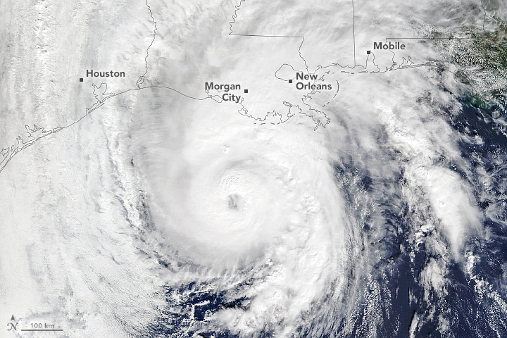
Cameras outside the International Space Station captured dramatic views of Hurricane Zeta at 12:50 pm ET October 28, as it churned 200 miles south-southwest of New Orleans packing winds of 90 miles an hour. Credit: NASA
Aiding Risk Reduction, Response and Recovery
To aid local communities in preparing for and recovering from hurricanes and other disasters, the NASA Earth Applied Sciences Disasters Program coordinates a team of experts across NASA centers to provide vital Earth-observing data and analysis. For Hurricanes Laura, Sally, and Delta, the program worked closely with stakeholders from the Federal Emergency Management Agency (FEMA), the Louisiana National Guard, and the Alabama Emergency Management Agency to provide guidance and analysis both in meetings and through data distributed on the NASA Disasters Mapping Portal. Near real-time data for tracking the storm is also made available on the portal’s Tropical Cyclone Dashboard. The program stands ready to continue to work with these agencies and provide assistance for Hurricane Zeta should the need arise.
Combining multiple datasets and tools allows NASA to see the big picture of a storm and its impacts, and helps answer broader questions about how communities can better prepare for, and recover from, the storms of the future. For Hurricane Zeta, researchers will have a unique opportunity to gauge the vulnerability or resilience of a region that was recently impacted by several destructive storms, and to study their compounding effects. Attempting to determine what damage was caused by which storm will be a challenging task on its own. However, attempting to answer these tough questions can provide critical guidance to help communities build back better and strengthen them for the disasters and challenges that lie ahead.

