No matter where you are located on this globe, we all have one thing in common – we all call planet Earth our home!
Earth provides humanity with everything we need to survive. Earth Day is a time to acknowledge what we can do to help our planet. With more than a billion people participating every year, Earth Day is the largest secular observation in the world. Let’s look at three ways NASA is impacting the Earth.
1.) Global Ecosystems Dynamic Investigation (GEDI): GEDI provides a unique 3D view of Earth’s forests, helping to fill in missing information about their role in the carbon cycle. The primary purpose of GEDI is to produce high-resolution laser-ranging observations of Earth in order to characterize the effects of climate change and land use on ecosystems’ structure and dynamics. GEDI beams down laser pulses into tree canopies to reveal more about our environment and how it is changing.

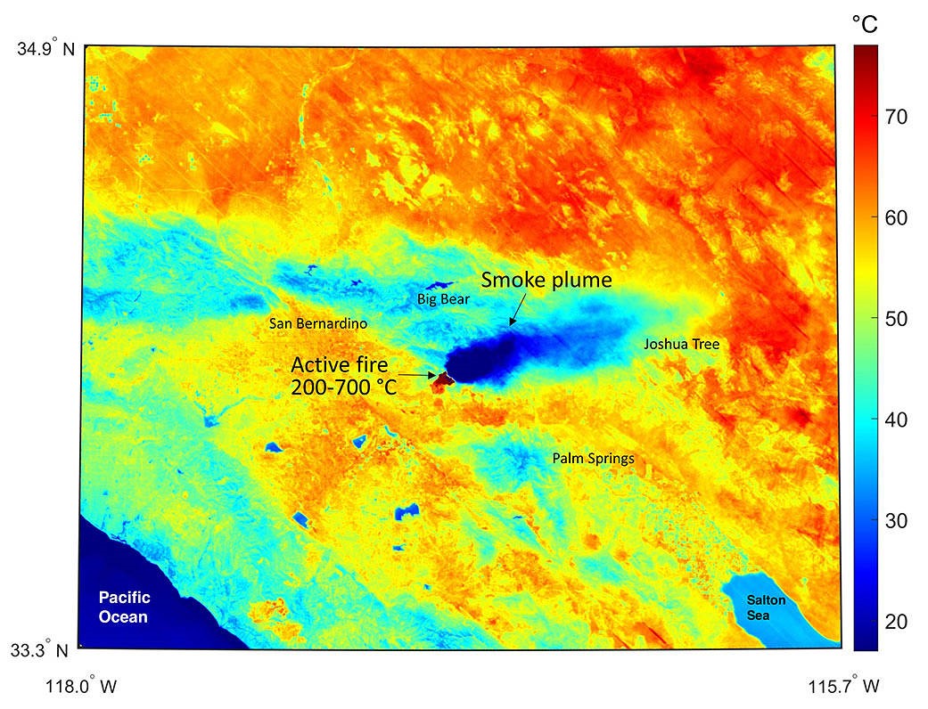
2.) ECOsystem Spaceborne Thermal Radiometer Experiment on Space Station (ECOSTRESS): ECOSTRESS monitors the loss of water through tiny pores in the leaves of living plants. The experiment measures combined evaporation and transpiration, known as evapotranspiration. The study uses high-resolution thermal infrared radiometer, which works like a giant thermometer from space, to measure the temperature of plants and the amount of heat radiating from Earth’s surface.
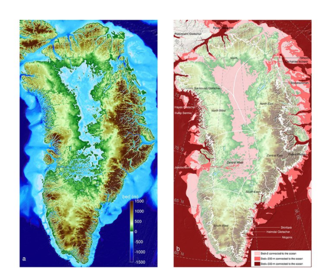
3.) Ocean’s Melting Greenland (OMG): The OMG mission is paving the way for improved estimates of sea-level rise by addressing the question: to what extent are the oceans melting Greenland’s ice from below? The OMG campaign examined the temperatures and other properties of North Atlantic waters along the coast, while also taking measurements of the glaciers that reach the ocean. The study examines why the Tracy and Heilprin glaciers, which flow side by side, are melting at different rates. The study documents a plume of warm water flowing up Tracy’s underwater face and a much colder plume in front of Heilprin.
Credit: UCI.
Earth Day is an opportunity for everyone from around the globe to come together. As a NASA intern, you set the example for other students around the globe. This Earth Day let’s make an impact. Tag us @NASAINTERNS and show us how you are making a difference this Earth Day!
Written by: Waryn Flavell