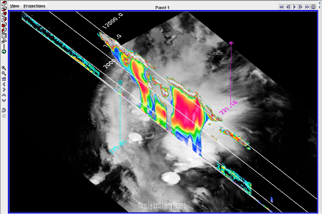
A combination of CALIPSO lidar data and CloudSat cloud radar reflectivity profiles are visualized over a greyscale MODIS infrared temperature image. This McIDAS-V display illustrates the vertical structure of deep convective clouds and the corresponding cloud-top temperatures, allowing scientists to better integrate and understand the measurements from these three NASA instruments. Image courtesy of Kristopher Bedka.
The latest version of a cutting-edge visualization program will help scientists at NASA Langley better understand what their observations are telling them about clouds and climate.
The McIDAS-V software, developed by the University of Wisconsin-Madison Space Science and Engineering Center, allows users to merge large amounts of data from multiple instruments and different times and resolutions into integrated visualizations. The result is a fuller picture of what’s going on in the atmosphere.
Satellites provide scientists with huge amounts of data everyday and organizing that data into digestible information has been a challenge. McIDAS-V will save scientists a lot of time and will allow them to look at their data in new ways.
“Visually appealing images that would involve a scientist writing thousands of lines of code can be created in a few clicks of the mouse. The software also allows scientists to find potential issues in their products and fix them to produce more accurate data,” said Kristopher Bedka, NASA Langley Research Center representative to McIDAS advisory committee.
At Langley, the software could be applied to projects including geostationary clouds and radiation products, cloud height measurements, real time weather observation data, ground-based weather radar observations, severe storm detection products, and observations from the NASA A-Train including MODIS, AIRS, CALIPSO and CloudSat.
Using the software to look at data in new ways could help Langley scientists answer questions and solve problems related to the Earth’s climate like how clouds are changing and how they will affect Earth’s energy balance. The goal is to understand how Earth and its atmosphere interact and how changes will affect the climate.
Using the new software, weather satellite imagery can be displayed including the fourth dimension, time, and data can be looked at in a global view. McIDAS-V can access remote and local data and it also allows collaboration between scientists through the sharing of portable data bundles.
McIDAS software has been used in cloud retrieval work for the last 20 to 30 years. McIDAS-V is an update to an earlier version of the software, McIDAS-X. McIDAS-V has advances in data analysis and visualization in geophysical data in response to the increasing volume and complexity of geophysical data, increasing computer processing speed and memory, and new satellite instrumentation.
Being able to view all this new data in diverse ways, means more possibility for advances in research about Earth’s weather and climate.
McIDAS is a free resource available at the University of Wisconsin-Madison Space Science and Engineering Center Web site.
–Kristyn Ecochard, NASA’s Earth Science News Team
