AGU2011: New Project Aims to Predict South Asian Floods

What’s happening to Himalayan glaciers, rivers, lakes, and streams has become one of the most important – and widely debated – topics in science.

There’s certainly no shortage of questions. Which of the 15,000 glaciers in the region are retreating and which growing? How many glacial lakes are on the verge of bursting their banks and flooding downstream communities? Will the region’s great rivers, such as the Indus and the Ganges, be able to withstand the region’s changing climate and rapid population growth and continue to sustain the hundreds of millions of people who depend on them? How can devastating floods, such as the one that struck Pakistan last year, be avoided?

Firm answers to such questions have been hard to come by in recent decades because of the limited monitoring resources available in many key countries in the region. Now, however, a new effort, dubbed HIMLA and led by Molly Brown of NASA’s Goddard Space Flight Center, aims to change this by harnessing state-of-the-art, satellite-based monitoring and modeling techniques.

As part of the effort, scientists will feed data from satellite instruments such as MODIS and ASTER into a hydrological model that will produce daily snow/water equivalence maps that will feed into other hydrological models to determine how much freshwater flows into the region’s rivers from snow and glaciers. The ultimate goal: an early warning system that, like the Famine Early Warning System Network does for drought, will help predict floods before they happen.

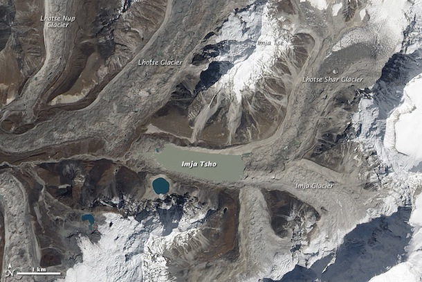
Text by Adam Voiland. Molly Brown spoke about the topic  at an American Geophysical Union Meeting on Dec. 6, 2011. Pakistan flooding photograph (top) ©2010 Tariq Saeed/IRIN. Image of Imja Tsho (bottom), one of the world’s fastest growing glacial lakes, originally published by NASA’s Earth Observatory.

For the Swollen Mississippi the Atchafalaya Beckons


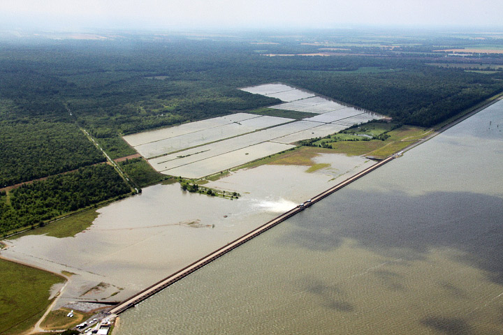
The storms that recently sent a rash of tornadoes through the South have produced historic flooding along the Mississippi River. Over the weekend, the U.S. Army Corps of Engineers opened the Morganza Spillway in Louisiana for just the second time since buidling the structure in 1954.

Though the action will likely lessen damage in the major cities of New Orleans and Baton Rouge, opening the Morgananza will inundate thousands of square kilometers of land and displace between 30,000 and 60,000 people as spillover swells the Atchafalaya River.

The Atchafalaya, as the New Yorker’s John McPhee explains in masterly fashion in The Control of Nature, is on the verge of capturing the Mississippi’s flow. The Army Corps of Engineers diverts just 30 percent of the Mississippi’s water into the Atchafalaya, though the natural inclination of the Mississippi is to jump its banks and flow into the shorter and steeper Atchafalaya channel.

McPhee, in an essay that’s as relevant today as it when it was first published in 1987, describes the daunting challenge engineers face in trying to keep the Mississippi within its banks. It makes for sobering reading, but the essay makes an excellent complement to the series of satellite photos NASA’s Earth Observatory has released chronicling the flooding.

In the excerpt below, McPhee describes the Mississippi’s tendency to shift its course in swift and dramatic ways:

The Mississippi River, with its sand and silt, has created most of Louisiana, and it could not have done so by remaining in one channel. If it had, southern Louisiana would be a long narrow peninsula reaching into the Gulf of Mexico. Southern Louisiana exists in its present form because the Mississippi River has jumped here and there within an arc about two hundred miles wide, like a pianist playing with one hand—frequently and radically changing course, surging over the left or the right bank to go off in utterly new directions. Always it is the river’s purpose to get to the Gulf by the shortest and steepest gradient. As the mouth advances southward and the river lengthens, the gradient declines, the current slows, and sediment builds up the bed. Eventually, it builds up so much that the river spills to one side. Major shifts of that nature have tended to occur roughly once a millennium. The Mississippi’s main channel of three thousand years ago is now the quiet water of Bayou Teche, which mimics the shape of the Mississippi. Along Bayou Teche, on the high ground of ancient natural levees, are Jeanerette, Breaux Bridge, Broussard, Olivier—arcuate strings of Cajun towns. Eight hundred years before the birth of Christ, the channel was captured from the east. It shifted abruptly and flowed in that direction for about a thousand years. In the second century a.d., it was captured again, and taken south, by the now unprepossessing Bayou Lafourche, which, by the year 1000, was losing its hegemony to the river’s present course, through the region that would be known as Plaquemines. By the nineteen-fifties, the Mississippi River had advanced so far past New Orleans and out into the Gulf that it was about to shift again, and its offspring Atchafalaya was ready to receive it. By the route of the Atchafalaya, the distance across the delta plain was a hundred and forty-five miles—well under half the length of the route of the master stream.

For the Mississippi to make such a change was completely natural, but in the interval since the last shift Europeans had settled beside the river, a nation had developed, and the nation could not afford nature. The consequences of the Atchafalaya’s conquest of the Mississippi would include but not be limited to the demise of Baton Rouge and the virtual destruction of New Orleans. With its fresh water gone, its harbor a silt bar, its economy disconnected from inland commerce, New Orleans would turn into New Gomorrah. Moreover, there were so many big industries between the two cities that at night they made the river glow like a worm. As a result of settlement patterns, this reach of the Mississippi had long been known as “the German coast,” and now, with B. F. Goodrich, E. I. du Pont, Union Carbide, Reynolds Metals, Shell, Mobil, Texaco, Exxon, Monsanto, Uniroyal, Georgia-Pacific, Hydrocarbon Industries, Vulcan Materials, Nalco Chemical, Freeport Chemical, Dow Chemical, Allied Chemical, Stauffer Chemical, Hooker Chemicals, Rubicon Chemicals, American Petrofina—with an infrastructural concentration equalled in few other places—it was often called “the American Ruhr.” The industries were there because of the river. They had come for its navigational convenience and its fresh water. They would not, and could not, linger beside a tidal creek. For nature to take its course was simply unthinkable. The Sixth World War would do less damage to southern Louisiana. Nature, in this place, had become an enemy of the state.

Text by Adam Voiland. Photographs published originally by NASA’s Earth Observatory.

NASA's Pouring Funds, Scientists and Satellites into Pakistan Flood Warning

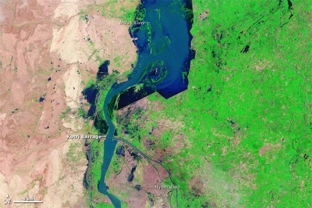
In July 2010, monsoon rains came to Pakistan in a Biblical way. Three months’ worth of rain fell in just one week. Historic flooding ensued in the weeks to follow — spanning 600 miles along the flood zone of the Indus River Valley — taking the lives of as many as 1,600 people. The flood waters also displaced as many as 20 million.

If only the warnings of historic flooding had come more swiftly and more accurately, it’s possible some of those who perished could have lived to tell about it. Countless numbers of the nearly 2 million homes destroyed might still be standing. And relief aid to refugees of the floods might have reached villages in need with greater precision and speed. If only…

Humanitarian aid efforts in the months after the flooding have been generous, but have paled in comparison with Haitian earthquake relief, and the world’s response to the aftermath of the 2004 Asian tsunami. But, additional assistance continues to arrive. In at least one instance that assistance hails in part from an unconventional source – NASA — with a native son of Pakistan leading the charge.

Growing up in a rural mountainous area near Gilgit, Pakistan, Sadiq Khan never experienced first-hand any of the devastation that more often than not wreaks havoc on the country’s densely populated, lower lying regions like Punjab and Sindh. But, a few years following the untimely death of a friend in the 2005 earthquake that killed upwards of 85,000, Khan, a graduate research assistant at the University of Oklahoma (OU), along with associate professor Yang Hong of the school’s Remote Sensing Hydrology Group, developed a proposal to build Pakistan’s capacity to reduce the risk of life and agricultural damage during natural disasters. And a specific proposal focus – developing an early warning system for flooding – would prove serendipitous.

On the heels of the catastrophic floods, Khan and Hong received a half-million dollar grant in August for their three-year project from the Pakistan – U.S. Science and Technology Cooperation Program that Pakistan’s government and the U.S. Agency for International Development are funding. Of the 28 projects (out of 270 applications) chosen for funding, Khan’s ranked as the most relevant to society.

“Pakistan has been limited by a lack of human resources, training for personnel, and data availability,” said Khan, who is also a 2008-2011 NASA Earth Sciences Graduate Fellow. “So, the reliability of the current flood-warning system in Pakistan is poor, and likely the reason flood mortality was unusually high. They’re using an older generation of hydrologic models, probably from the 1980s, that don’t require remote sensing data.”

So, where does NASA come in? Well, Khan, NASA collaborator Shahid Habib, head of applied sciences at NASA’s Goddard Space Flight Center, and other colleagues will work to train Pakistani scientists to access and use free data from several of NASA’s remote sensing satellites in what are called predictive hydrometeorological models. These models can improve the ability to forecast floods accurately and with more warning time.

Starting in mid-November, Khan and others will begin three years of training researchers at the National University of Science and Technology in Islamabad to use a flood model they developed at OU in collaboration with NASA that makes use of a lot of NASA data.

They’ll use precipitation data from NASA’s Tropical Rainfall Measurement Mission satellite, because heavy rain causes most of flooding. The model also uses a whopping amount of other NASA remote-sensing information: digital elevation (Digital Elevation Model), topographical (Shuttle Radar Topography Mission), radiometry (Advanced Spaceborne Thermal Emission and Reflection Radiometer), and land cover data (from an instrument aboard NASA’s Terra and Aqua satellites), as well as soil moisture estimates from Advanced Microwave Scanning Radiometer – Earth Observing System Advanced Microwave Scanning Radiometer – Earth Observing System.

“The plains agricultural regions – the ‘bread basket’ of Pakistan – suffered extreme damage in the floods and the deaths were heartbreaking,” Khan explained. “So, it’ll be an honor for me to go back home, visit affected areas that are home to more than 100 million people, evaluate needs, and work with my government to create a 21st-century flood-warning system that can prevent this level of suffering from flooding from occurring again.”

— Gretchen Cook-Anderson, NASA’s Earth Science News Team; Images courtesy of  the NASA Earth Observatory (top) and Sadiq Khan (bottom).
When It Rained,It Poured

Satellite image
The image shows estimates of rainfall for the southeastern United States from
September 14–21. The estimates, acquired by multiple satellites, are calibrated
with rainfall measurements from NASA’s Tropical Rainfall Measuring Mission
(TRMM)satellite. The highest rainfall amounts—more than 300 millimeters
(11.8 inches)—appear in blue. The lightest amounts appear in pale green.
Credit: NASA/Jesse Allen

For the past four years, drought has parched the soil of north Georgia farms, nearly drained Atlanta’s 38,000-acre reservoir, and left area lawns brown. Then in just eight days in September 2009, the region’s weather took a turn that likely had residents asking if they were on a climate seesaw.


As millions of Georgians watched and as many fled for higher ground, meteorological forces coalesced to deliver heavy rains and flooding not seen in the southeastern U.S. in more than 100 years, according to the National Weather Service.


Millions of dollars of property were destroyed, and ten lives were lost. The flooding dominated local TV news and compelled the governor to declare a state of emergency across 17 counties.


Even before the rains ended, research meteorologist, Marshall Shepherd a professor of Atmospheric Sciences at the University of Georgia, and colleagues began piecing together rainfall and soil moisture data from NASA satellites, Doppler radar, weather reports and ground-level rain gauges to assemble a clearer picture of the climatological factors that fueled the flooding.


Though not yet peer reviewed, Shepherd’s initial findings suggest what may have prompted the downpours and floods. Moisture from the Gulf of Mexico was drawn into the southeast by a stalled low pressure system from the Mississippi Valley. The moist air and a series of meteorological disturbances merged with a key ingredient – a dramatic increase in urban land cover – to bring this historic weather event to the region for the second time in as many years.


“We had days and days of downpours and an extraordinary 24-hour rainfall event at the end of that period. With soil moisture already at a high, the rain could no longer infiltrate the soil and we reached a tipping point for flooding,” explained Shepherd, a native of metropolitan Atlanta who NASA has funded to investigate how urban land cover and pollutants affect rainfall and surface water changes. 


“The rain and the soil moisture content combined to overwhelm rivers and streams,” he said. “Add to that Atlanta’s impenetrable roads and sidewalks, which increase the volume of runoff, and you get the event of record we witnessed.”


According to Shepherd, the long drought in the southeast – which caused job losses in agriculture and lawncare and other water use hardships across many sectors of society — is now over.  


“In fact, October is normally the driest month in North Georgia,” Shepherd said. “But this year, sea surface temperature data from NASA and NOAA satellites tell us a moderate El Nino in the Pacific appears likely to lead to a cooler and wetter fall and winter in the Southeast.”


Curiously, drought may be the last of Atlanta residents’ weather worries in the next season or two to come.


–Gretchen Cook-Anderson, NASA’s Earth Science News Team