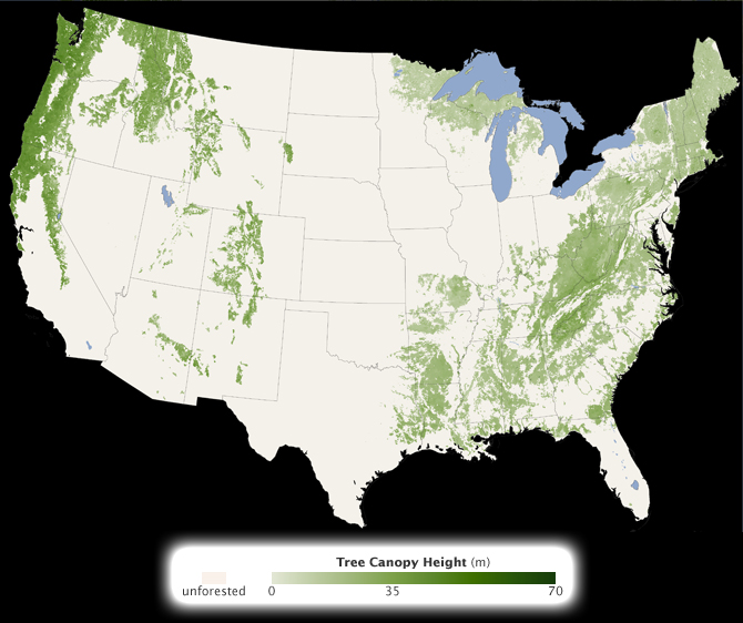
 Colorado State University researcher Michael Lefsky recently published the first global map of forest heights using data from an radar-like laser instrument — the Geoscience Laser Altimeter System (GLAS) — aboard NASA’s IceSat satellite. The work should help scientists build an inventory of how muchcarbon the world’s forests store and how fast that carbon cycles throughecosystems and back into the atmosphere. We spoke with Michael to learn more about the work behind his work…
What on Earth: How did you get into this line of work?
Lefsky: I went to the University of Virginia to study the modeling of forest structure. My graduate advisor was working with NASA, and one day he came back with a single waveform lidar graph, one of the first ever produced. That was it: I knew this was what I wanted to work on.
What on Earth: What do you mean by forest structure and why go to the trouble of studying it?
Lefsky: We were looking at things like the size and number of stems in forests. We were also looking at how forests change over time and across landscapes. It’s critical to understand forest structure if you want to understand how much carbon forests are storing. You need to know whether a forest is growing, in stasis, or has been disturbed. We used to study this kind of thing by basically counting stems. But when I looked at that waveform lidar data, I could see it was a record of exactly the same thing, but from a completely different perspective.
What on Earth: I’m guessing you could collect in seconds the same amount of data it takes weeks to get in the field?
Lefsky: Actually, less than a second.
 What on Earth: But are there insights that you can get from the ground that you can’t get from space?
Lefsky: Sure, but you have to keep the scale in mind. In the field, we basically estimate forest height by measuring diameter of trunks at breast height. That’s sort of like trying to study a person’s size and metabolism by measuring the diameter of their ankles. Lidar gives you a whole bunch of new information about the vertical structure of forest canopy. This is something that’s hardly ever investigated from the ground, or could only be investigated with great difficulty.
What on Earth: What are the most satisfying and frustrating aspects of working with remote sensing data?
Lefsky: I love what I do. I am incredibly lucky. I don’t really see frustrations, just challenges. In this case, there are enormous challenges involved with working on a completely new kind of data and figuring out how to process such large amounts of information. The flip side is that coming to new levels of understanding about what’s going on in the world is incredibly satisfying.
What on Earth: If there was one thing you wish people knew about your science, what would it be?
Lefsky: I wish people knew what tremendous things NASA’s Earth Science Division does for our understanding and ability to plan for the future of the global environment. People think space shuttle. People think the Moon. I think that the Earth science part of NASA is woefully under-appreciated.

Bravo to you and everyone at NASA. You are so right about how people think about NASA and that it is just about the space shuttles. I have been a NASA fan since childhood and appreciate all that NASA does for this country and the world as a whole. Keep up the good work.
I’ve always been amazed by this
What a fascinating job. You are right, the moment you say NASA; people think ‘space’. I used to flat with a rocket scientist who worked on scram-jets for the Melbourne University (he’s now based in Brisbane). His job was interesting too. It seems like everybody who works in this arena has great work satisfaction. However, the greater majority of people have very little grasp of what else NASA does for the planet.