Wandering Storms in a Warming World
Most people know climate change is causing glaciers to retreat in Earth’s polar regions, but that’s hardly the only change warming temperatures can produce. A new study, led by Frida Bender of the Scripps Institute of Oceanography and published in Climate Dynamics, shows that the tracks of mid-latitude storms – the type that drives the weather systems that affect Americans the most – have shifted poleward and narrowed over the last 25 years as a result of climate change. What’s more, as the Jet Propulsion Laboratory’s Graeme Stephens notes in a Nature Climate Change article about the study, Bender’s satellite-based research shows that the cloudiness of the storm tracks has decreased over the same period. That’s important as it suggests the decline may have increased the net flux of radiation at the top of Earth’s atmosphere over storms – a process that could amplify warming over time.
Ocean Temperatures a Factor in Arctic Ozone Loss
In March of 2011, the World Meteorological Organization put out a statement announcing an unprecedented loss of stratospheric ozone over the Arctic. Between the beginning of winter and late March ozone levels declined by 40 percent due to unusually cold temperatures in the Arctic stratosphere. (Cold temperatures hasten ozone destruction by making it possible for a certain type of cloud to form that hosts ozone-depleting chemical reactions). But what caused the cold spell? A new study authored by Margaret Hurwitz of Goddard Space Flight Center and published in Atmospheric Chemistry and Physics Discussions points out that unusually warm sea surface temperatures in the North Pacific likely played a key role. The phase of the solar cycle, greenhouse gas emissions, nor El Niño/La Niña oscillations can fully the explain the unusual conditions, she notes.
Can Satellites Help Save the Burrowing Owl?
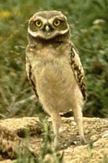
Burrowing owls, one of the world’s smallest owl species, live in the abandoned tunnels of small mammals such as ground squirrels and prairie dogs. The long-legged birds, which typically weigh just 6 ounces, are losing ground to development and some conservation groups put the number of breeding burrowing owls at a mere 10,000. A new study, published in the Canadian Journal of Remote Sensing, suggests that crop classification imagery from Landsat satellites could be used to evaluate owl demographics and help with conservation plans as agricultural areas experience short-term changes.
Hang Tight, LandSat 5
Speaking of LandSat, Landsat 5, launched in 1984, is still operating more than a quarter of a century later despite having an original design life of three years. However, the reality that LandSat 5’s critical Thematic Mapper instrument, which many agencies around the world rely upon, won’t last indefinitely is becoming increasingly difficult for scientists to ignore as the satellite ages. Since Landscape 6 failed to reach orbit and LandSat 7’s Enhanced Thematic Mapper, which reached orbit in 1999, has a glitch that omits key strips of images, there’s a real possibility that top-tier LandSat images won’t be available until the Landsat Data Continuity Mission launches in December of 2012, a new study in the Canadian Journal or Remote Sensing cautions. The Australian authors of the study tested some of the alternative satellite data products, but none of them quite measured up to LandSat 5 in their view.
Locavores Take Note
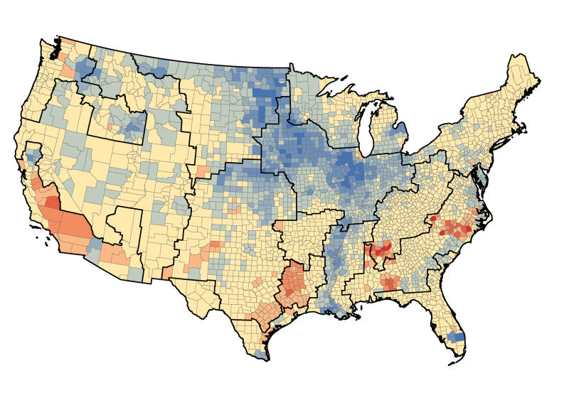
Climate models generally assume that the carbon agricultural crops take up later reenters the atmosphere in approximately the same geographic area, but in reality food gets shipped long distances before we consume it. A new paper, authored by Tristram West of the Pacific Northwest National Laboratory (PNNL) and published in Biogeosciences, accounts for the mobile nature of food and shows how regions that rely on food from distant areas end up releasing the carbon that comes with it into the atmosphere. Overall, as noted in the PNNL press release, the researchers found that crops take in — and later return — about 37 percent of the U.S.’s total annual carbon dioxide emissions, but that the amount varies significantly by region. Agriculturally active regions of the Midwest, Great Plains, and along the southern half of the Mississippi (shown in blue below) release more carbon than they take in, while more urban parts of the Northeast, Southeast, Western U.S. and Gulf Coast (shown in red below) take in more than they release.

Text by Adam Voiland. Extratropical storm imagery from the Earth Observatory. Burrowing owl imagery from the city of Boulder. Agricultural carbon sink and source map from Science Daily.

I do not have a coment but I do have a question. Judgeing on how fast the climate is changeing, how long do you think our planet has before the green house gasses completely destroy it. Please e-mail me NASA’s estimate.
Just to clarify: Under the “locavores take note” article, it says
“Agriculturally active regions of the Midwest, Great Plains, and along the southern half of the Mississippi (shown in blue below) release more carbon than they take in, while more urban parts of the Northeast, Southeast, Western U.S. and Gulf Coast (shown in red below) take in more than they release.”
I read the abstract, and it suggests the reverse, that the Northeast et al. release more Carbon than they take in.
Let me know if I misread the abstract.
Best,
Josh