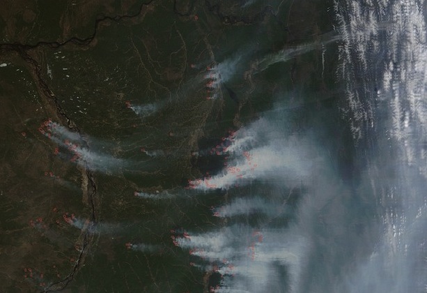
Fires Rage in Siberia


The storms that recently sent a rash of tornadoes through the South have produced historic flooding along the Mississippi River. Over the weekend, the U.S. Army Corps of Engineers opened the Morganza Spillway in Louisiana for just the second time since buidling the structure in 1954.
Though the action will likely lessen damage in the major cities of New Orleans and Baton Rouge, opening the Morgananza will inundate thousands of square kilometers of land and displace between 30,000 and 60,000 people as spillover swells the Atchafalaya River.
The Atchafalaya, as the New Yorker’s John McPhee explains in masterly fashion in The Control of Nature, is on the verge of capturing the Mississippi’s flow. The Army Corps of Engineers diverts just 30 percent of the Mississippi’s water into the Atchafalaya, though the natural inclination of the Mississippi is to jump its banks and flow into the shorter and steeper Atchafalaya channel.
McPhee, in an essay that’s as relevant today as it when it was first published in 1987, describes the daunting challenge engineers face in trying to keep the Mississippi within its banks. It makes for sobering reading, but the essay makes an excellent complement to the series of satellite photos NASA’s Earth Observatory has released chronicling the flooding.
In the excerpt below, McPhee describes the Mississippi’s tendency to shift its course in swift and dramatic ways:
The Mississippi River, with its sand and silt, has created most of Louisiana, and it could not have done so by remaining in one channel. If it had, southern Louisiana would be a long narrow peninsula reaching into the Gulf of Mexico. Southern Louisiana exists in its present form because the Mississippi River has jumped here and there within an arc about two hundred miles wide, like a pianist playing with one hand—frequently and radically changing course, surging over the left or the right bank to go off in utterly new directions. Always it is the river’s purpose to get to the Gulf by the shortest and steepest gradient. As the mouth advances southward and the river lengthens, the gradient declines, the current slows, and sediment builds up the bed. Eventually, it builds up so much that the river spills to one side. Major shifts of that nature have tended to occur roughly once a millennium. The Mississippi’s main channel of three thousand years ago is now the quiet water of Bayou Teche, which mimics the shape of the Mississippi. Along Bayou Teche, on the high ground of ancient natural levees, are Jeanerette, Breaux Bridge, Broussard, Olivier—arcuate strings of Cajun towns. Eight hundred years before the birth of Christ, the channel was captured from the east. It shifted abruptly and flowed in that direction for about a thousand years. In the second century a.d., it was captured again, and taken south, by the now unprepossessing Bayou Lafourche, which, by the year 1000, was losing its hegemony to the river’s present course, through the region that would be known as Plaquemines. By the nineteen-fifties, the Mississippi River had advanced so far past New Orleans and out into the Gulf that it was about to shift again, and its offspring Atchafalaya was ready to receive it. By the route of the Atchafalaya, the distance across the delta plain was a hundred and forty-five miles—well under half the length of the route of the master stream.
For the Mississippi to make such a change was completely natural, but in the interval since the last shift Europeans had settled beside the river, a nation had developed, and the nation could not afford nature. The consequences of the Atchafalaya’s conquest of the Mississippi would include but not be limited to the demise of Baton Rouge and the virtual destruction of New Orleans. With its fresh water gone, its harbor a silt bar, its economy disconnected from inland commerce, New Orleans would turn into New Gomorrah. Moreover, there were so many big industries between the two cities that at night they made the river glow like a worm. As a result of settlement patterns, this reach of the Mississippi had long been known as “the German coast,” and now, with B. F. Goodrich, E. I. du Pont, Union Carbide, Reynolds Metals, Shell, Mobil, Texaco, Exxon, Monsanto, Uniroyal, Georgia-Pacific, Hydrocarbon Industries, Vulcan Materials, Nalco Chemical, Freeport Chemical, Dow Chemical, Allied Chemical, Stauffer Chemical, Hooker Chemicals, Rubicon Chemicals, American Petrofina—with an infrastructural concentration equalled in few other places—it was often called “the American Ruhr.” The industries were there because of the river. They had come for its navigational convenience and its fresh water. They would not, and could not, linger beside a tidal creek. For nature to take its course was simply unthinkable. The Sixth World War would do less damage to southern Louisiana. Nature, in this place, had become an enemy of the state.
Text by Adam Voiland. Photographs published originally by NASA’s Earth Observatory.

Between April 25 and April 28, a record-breaking total of 362 tornadoes tore through the southeastern and central United States. Could climate change fuel such an unprecedented cluster of twisters? A number of commentators have addressed the question, but the most concise answer I’ve heard yet comes in the 36th minute of an On Point interview with NOAA tornado expert Harold Brooks. [The bolding is mine.]
On Point: When you look at the architecture of the weather that produced these storms can you tie it to global climate change? We’ve seen warning after warning saying that we may see an increase in storm conditions because of climate change.
Brooks: Well, the planet has undoubtedly warmed in the last 50 to 100 years. And it will undoubtedly continue to warm as greenhouse gases play a greater role. It’s not really clear what the connection is between tornadoes [and climate change] in particular. Some of the ingredients we look for in the production of supercells, such as the warm moist air at low levels, are going to increase in intensity and frequency and be supportive of supercell storms. On the other hand, one of the main predictions of climate change is that the equator to pole temperature difference will decrease because the poles will warm more than the equator. That’s related to the change of the winds with height term, which is one of the things that helps organize storms and make them more likely to produce tornadoes. That’s predicted to lessen as we go along. So we’ve got some ingredients that will be increasing in intensity and some that will be decreasing. If we look historically at the record and try to make some adjustments over the last 50 years for what we know is changes in reporting, we really see no correlation between occurrence and intensity and global surface temperatures or even the US national temperature.
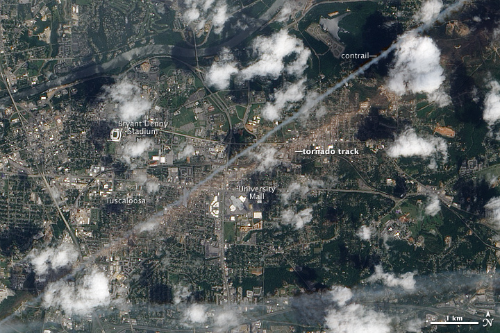
While scientists will surely continue to study this, one thing is quite certain: When tornadoes do come along, NASA will do all it can to track and monitor them and their aftermath using satellites and other assets. On May 2, 2011, for example, the NASA Earth Observatory reported that the Advanced Land Imager (ALI) on NASA’s Earth Observing-1 (EO-1) satellite captured the natural-color image above of a massive tornado’s destructive path through Tuscaloosa.
The trail of damage stretched 80.3 miles (129.2 kilometers) long and as much as 1.5 miles (2.4 kilometers) wide.The tan-toned, debris-filled path passes through the center of town, affecting both commercial and residential properties. The track passes south of Bryant Denny Stadium and just north of University Mall. The Tuscaloosa tornado caused more than 1,000 injuries and at least 65 deaths across several town and cities, the highest number of fatalities from a single tornado in the United States since May 25, 1955. –Adam Voiland
Everyone knows NASA as the space exploration agency. It’s easy to forget that exploring Earth is also exploring a celestial body. It is, in fact, the only planet we’ve ever been to — our Home Frontier.
For Earth Day 2011, we ask you to step back from the daily, incremental science results, and think about a larger question: What is inspiring to you about our home planet? What is important and vital about NASA’s exploration of Earth? Then, go capture that in a short web video.
Read more about The Home Frontier: NASA’s Earth Day Video Contest.
Get free footage of Earth from NASA to use in your video.