Between April 25 and April 28, a record-breaking total of 362 tornadoes tore through the southeastern and central United States. Could climate change fuel such an unprecedented cluster of twisters? A number of commentators have addressed the question, but the most concise answer I’ve heard yet comes in the 36th minute of an On Point interview with NOAA tornado expert Harold Brooks. [The bolding is mine.]
On Point: When you look at the architecture of the weather that produced these storms can you tie it to global climate change? We’ve seen warning after warning saying that we may see an increase in storm conditions because of climate change.
Brooks: Well, the planet has undoubtedly warmed in the last 50 to 100 years. And it will undoubtedly continue to warm as greenhouse gases play a greater role. It’s not really clear what the connection is between tornadoes [and climate change] in particular. Some of the ingredients we look for in the production of supercells, such as the warm moist air at low levels, are going to increase in intensity and frequency and be supportive of supercell storms. On the other hand, one of the main predictions of climate change is that the equator to pole temperature difference will decrease because the poles will warm more than the equator. That’s related to the change of the winds with height term, which is one of the things that helps organize storms and make them more likely to produce tornadoes. That’s predicted to lessen as we go along. So we’ve got some ingredients that will be increasing in intensity and some that will be decreasing. If we look historically at the record and try to make some adjustments over the last 50 years for what we know is changes in reporting, we really see no correlation between occurrence and intensity and global surface temperatures or even the US national temperature.
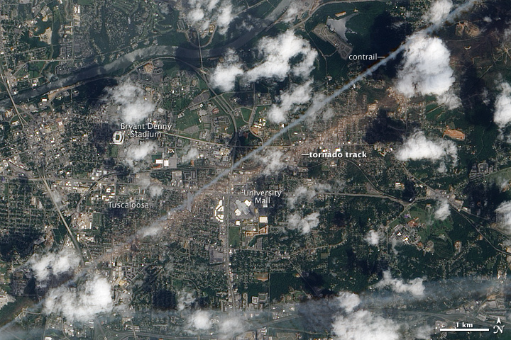
While scientists will surely continue to study this, one thing is quite certain: When tornadoes do come along, NASA will do all it can to track and monitor them and their aftermath using satellites and other assets. On May 2, 2011, for example, the NASA Earth Observatory reported that the Advanced Land Imager (ALI) on NASA’s Earth Observing-1 (EO-1) satellite captured the natural-color image above of a massive tornado’s destructive path through Tuscaloosa.
The trail of damage stretched 80.3 miles (129.2 kilometers) long and as much as 1.5 miles (2.4 kilometers) wide.The tan-toned, debris-filled path passes through the center of town, affecting both commercial and residential properties. The track passes south of Bryant Denny Stadium and just north of University Mall. The Tuscaloosa tornado caused more than 1,000 injuries and at least 65 deaths across several town and cities, the highest number of fatalities from a single tornado in the United States since May 25, 1955. –Adam Voiland
