NASA Earth Buzz: Steamy July, Shakedown in the Gulf, and Look How Good We All Look


Degrees of Change
New data from GISS puts July 2010 in a three-way tie with 1998 and 2005 for warmest July on record. (Earth Observatory)

“Shakedown” in the Gulf
NASA’s DC-8, which is in Florida preparing to hunt for hurricanes, took to the air this week for a practice flight as part of GRIP. (NASA.gov)

Fingerprints of Fire
A massive plume of carbon monoxide made its way across Asia, unleashed by Russian wildfires. (JPL)

A Bit of Elegance for Your Day
A visual artist at the Earth Observatory has a new blog on the development of science imagery; the first post offers fascinating details about imaging Eyjafjallajökull. (Elegant Figures)

Gray Marble
See Earth in its grayest and gloomiest glory. (My Big Fat Planet)

Straight to the Source
Tired of the filter? Get closer to the data with this new Twitter feed from the Data Information and Services Center at Goddard, one of eight core data dissemination groups across NASA. (NASA_GESDISC)

Tweet of the Week
We look good, don’t we? http://bit.ly/bPIAL4 (NASA_GoddardPix)

What On Earth is That? #3

(Please post your answers and your name in the comments, and we’ll give the answer next week….)

Here at What on Earth, we’re constantly stumbling across interesting photos, videos, and audio clips from NASA’s exploration of our planet (be it from space, the field, or the lab.). We’ve started posting snippets of them every now and then, usually on Fridays. What we post will change, but the question to you all will always be the same: “What on Earth is that?”

We’ll give you a week to mull it over and guess (use the comments), and we’ll post the answer the following Friday. Our only hints:

1) Our picks will always be related to Earth science in one way or another, and…

2) They’ll have some relation to what we do here at NASA.

Snowpocalypse Revisited


Though the summer heat and humidity makes it seem like a lifetime ago, the record-breaking snows in the eastern U.S. last winter are not something we will soon forget. Several feet of powder fell on most of the Mid-Atlantic region during February 2010, and this week a study from Columbia University’s Lamont-Doherty Earth Observatory gives us new insight into what caused the freaky weather.

A rare combination of weather — not climate — patterns seems to be the culprit. El Niño produced abnormally wet conditions in the southeastern U.S.; a negative North Atlantic Oscillation pushed frigid Arctic air down from the North. This collision of moisture with abnormally cold air led to more than six feet of snow over the region between December 2009 and February 2010.

The visualization above, derived from the Goddard Earth Observing System Model Version 5 (GEOS-5) and created by NASA Goddard’s Scientific Visualization Studio, shows the first wave of the February snowstorms hitting the East Coast about four seconds into the animation. The second wave forms off the west coast of Mexico’s Yucatan peninsula — about twelve seconds in — and then pummels the East Coast.

— Michelle Williams, NASA’s Goddard Space Flight Center

The First A in NASA Stands for Aeronautics

                                                                                                                                                                                        Credit: NASA
If you’ve explored NASA’s website, you may have noticed that What on Earth is just one of a network of NASA blogs. You can find many of them on this main index page, but there are also NASA bloggers scattered at numerous other pages.

Earth Observatory’s Notes from the Field focuses, for example, on scientific field campaigns. And NASA’s Climate Change website, which is run by the Jet Propulsion Laboratory (JPL), features a blog called My Big Fat Planet. At Goddard Space Flight Center (GSFC), Geeked on Goddard (aka gogblog), written by a former Astronomy blogger, is fast becoming a go-to-source for all things Goddard (and includes plenty of earth science news).  

Tony Freeman, an earth science manager at JPL and occasional contributor to My Big Fat Planet, wrote a post this week that caught our eye. Tony shines a spotlight on our fleet of research aircraft, based mostly at Dryden Flight Research Center, and gives a fabulous reminder that the first A in NASA stands for aeronautics. Here’s how he explains why we bother with aircraft:

Why bother with aircraft when we can fly spacecraft? Well, airborne missions enable us to do unique — and crucial — experiments in the fields of atmospheric chemistry and volcanology, for example, from altitudes that range from 100 feet (30 meters) to 60,000 feet (18 kilometers). They also help us to check and validate the performance of the instruments that fly onboard NASA satellites such as Aqua, Aura, and others in the so-called “A-train” of Earth-observing satellites. And airborne instruments are often cheaper to launch. Tethered and untethered balloons; manned aircraft ranging from small propeller craft (think Cessna) to large jet engines (think the DC-8 aircraft); unmanned airplanes such as the large surveillance craft known as the Global Hawk — NASA uses them all.

You can read the rest of Tony’s post here.

NASA Earth Buzz: Soot, the Big Melt, and More


What on Earth Was That?
Last week, we asked you to identify the image on the left, and we received all sorts of replies. (Nope, it’s not an ant eating salt, spitting acid, or laying eggs). The correct answer? A microscopic view of soot from a wildfire. Check the original post for more details.

The Big Melt
A massive chunk of glacial ice tumbled from the shores of Greenland on July 6-7. The calving front – where the ice sheet meets the ocean – retreated nearly 1.5 kilometers (a mile) in a day. The mass of ice lost was nearly 1/8 the size of Manhattan. (NASA.gov)

Get a GRIP on This
A group of NASA researchers based in Florida and southern California won’t be sipping lemonade by the beach this summer. Instead, they’ll be chasing hurricanes with three NASA aircraft. (JPL News)

Record Setting Heat Sears Mid-Atlantic Region
After the whopper snowstorms this winter, a broiling heat wave has descended on the U.S. Mid-Atlantic. By June 28, Washington DC had endured 10 consecutive days where temperatures soared above 90°F (32° C). (Goddard DISC)

Climate Connections
Have questions about global warming and climate change? Tired of all the spin? Try these straightforward questions and answers from NASA scientists and science writers. (Earth Observatory)

Coming to a Theater Near You
You’d have to be living under a rock not to know that NASA studies the Moon, Mars, and deep space. But as a rocket-pack clad astronaut points out in a new video short at your local movie theater, a big part of our mission is to study Earth. (NASA Explorer)

A Porthole on the Arctic
Get a glimpse of science in action as NASA-funded researchers cruise the Arctic on an icebreaker. (NASA HQ Flickr)

Tweet of the Week
Floods kill an average of 140 people per year in the U.S., making it the number one severe weather killer. (SciJinks)

Aerosol image (left) from Peter Buseck, Arizona State University. Fire image (right) from Jim Ross, NASA Dryden Flight Research Center.

NASA Earth Buzz: World Cup, New Climate Satellite, and a Five-Word Acceptance Speech We Love

Please view the slideshow on Firefox if you experience difficulty with Internet Explorer. You can also view it here and here.

World Cup Fever
You can’t quite make out the ball from space, but look at all that you can see (including a stadium and massive piles of slag in Johannesburg) in this soccer-inspired satellite slideshow. (NASA Goddard Flickr)

Adios El Niño, Hello La Niña?
The tropical Pacific has cooled during the last few months, perhaps foreshadowing a transition from El Niño to La Niña conditions. (Earth Observatory)

Just Five Words
NASA’s JPL-based climate change website picked up a Webby Award for best science site this week. We’re big fans of the 5-word-acceptance speech given by one of the site’s editors. (My Big Fat Planet)

Summer Haze
Clear skies, light winds, and long days with a high solar zenith are a recipe for haze and ozone–and that’s exactly what the last few days have brought in many parts of the country. (Smog Blog)

A Glorious New Mission
Enjoy the unique music–and an introduction to NASA’s newest climate monitoring satellite–in this newly released video about Glory. (NASA Explorer)

Tweet of the Week
From NASAHurricane: E.PACIFIC – Once a tropical storm, now a remnant, Blas has the blahs. Tropically speaking, that means that Blas is dissipating…. http://fb.me/BuNkFMJa (NASA Hurricane Page)

–Adam Voiland, NASA’s Earth Science News Team

NASA Earth Buzz

Earth science links, video, and more that caught our eye…


Tragedy in the Gulf
Heartbreaking video (above) from NASA shows a time-series of satellite snapshots of oil tendrils as they spread through the Gulf of Mexico. The video has appeared on the New Yorker and Gizmodo web sites and has garnered more than 600,000 views on YouTube. (NASAExplorer)

Who CARES About Urban Aerosols?
NASA scientist Matteo Ottiviani is blogging from an airborne field campaign in California, and he has a gift for making aerosols (small particles in the air, not the spray cans) sound exciting.   (Notes from the Field)

NASA Expedition Heads to the Arctic
Yep, we work from ships, too. A NASA-funded expedition has set sail for the Beaufort and Chukchi seas above Alaska to study the ecological impacts of sea ice decline. (IceScape Blog)

Supercomputing Climate Simulation Center Debuts
Many skeptics point to erratic models as the Achilles heel of climatology. A recently unveiled supercomputing center at Goddard, packed with more than 10,000 computer processors, should help. (NASA.gov)

Sensing the Sun’s Irradiance
Little fluctuations in the sun’s output might have more impact than you might think. A Q & A with the Glory Mission’s Judith Lean explores what it all means for climate. (NASA Earth Observatory)

New Earth Observer Is out
NASA’s bimonthly newsletter Earth Observer has news about IceSat, IceBridge, sea ice and more. It’s a somewhat technical read, but worth checking out. (Earth Observer – PDF)

Tweet of the Week
Why is permafrost like frozen chicken? http://go.usa.gov/3Ka (@NASA)

Though you may not know it, NASA has tens of thousands of websites devoted to earth science. It would be a Herculean task to keep track of all of them, so we created this column to save you the trouble. We’ll periodically scour what NASA has to offer and serve up the most fascinating, surprising, and thought-provoking Earth science we stumble across. Think we missed something? Post a comment in the most recent Earth Buzz.

–Adam Voiland, NASA’s Earth Science News Team

Beautiful Radiance

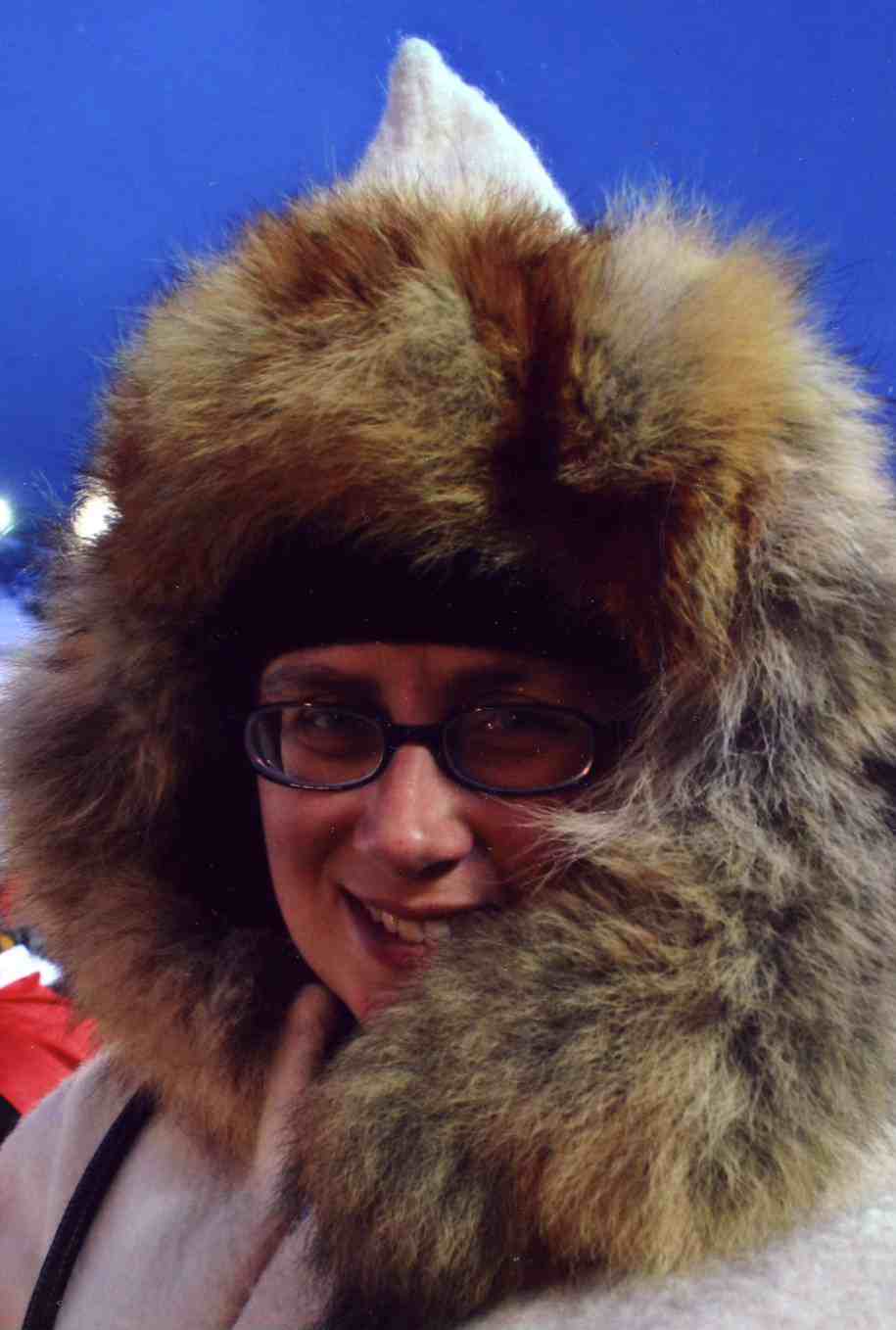
Karen Romano Young (right), a freelance writer and illustrator embedded with NASA’s ICESCAPE field campaign, sent this report from an icebreaker headed to the Arctic. You can follow the expedition on the ICESCAPE blog

Here on the U.S. Coast Guard Cutter Healy, heading north toward sampling stations in the Bering Strait, there’s plenty of light — a beautiful radiance nearly around the clock. Since arriving in Alaska on June 12, I’ve only awakened once in the middle of the night to find it dark. Last night at nearly 11 p.m., I sat drinking tea in front of my porthole, and saw a rainbow descend between strips of clouds into the grey Bering Sea. We’re in the land of the midnight sun, and as we continue north the night light will grow longer. It’s the opposite of the conditions that lead to Seasonal Affective Disorder down south where I come from (Connecticut!) For me, it’s joy.

Up here where there used to be more ice, the radiance is, well, radiating. This is the key: the Arctic ice reflects sunlight back into space. If there’s no ice, the sunlight goes into the water, warming it, and creating an environment in which phytoplankton — tiny plantlike algae at the water’s surface — can thrive. There’s less ice because our atmosphere is trapping greenhouse gases — carbon dioxide and methane — and the result is a warming Arctic.

Many of the 40-plus scientists participating in ICESCAPE, a NASA-led research cruise, are involved in studying the effects of sunlight. ICESCAPE stands for Impacts of Climate Change on the Eco-System of the Arctic Pacific Environment, and its purpose is to bring ice scientists and ocean scientists together to gather a greater understanding of the conditions in the Bering, Chukchi, and Beaufort Seas.

Who better to begin a discussion of the sun’s warming effects than a University of Washington scientist named Bonnie Light? Light has been working in the Arctic Ocean since 1998 when, as a grad student, she boarded the Canadian icebreaker Des Grosseilliers, which had purposely pulled up to the edge of the 1997 autumn ice and got fro-zen in through the 1998 thaw. That was the SHEBA (Surface Heat Budget of the Arctic) project, designed to increase understanding of the Arctic system.

Getting frozen in to the ice was a nod to the so-called “father of Arctic science,” Fridtjof Nansen, who purposely did the same a century earlier to prove his theory that the ice cap drifted. One of the purposes of SHEBA was to provide a baseline for under-standing Arctic conditions that might be affected by global warming. Several other scientists aboard ICESCAPE also participated in SHEBA, including Bonnie’s group leader and co-chief scientist Don Perovich.

The flight to the SHEBA site from Barrow, Alaska — the northernmost city in the United States — was the first time Light saw sea ice. “I’d calculated the total square kilometers that the Arctic ice cap occupies many, many times,” she said, “but to be in a little air-plane and fly over it and just see it…this endless stretch of pack ice was really striking.” During the ICESCAPE cruise she is eager to explore the western coast of Alaska for the first time.

“People have told me that the sea ice in the Chukchi Sea has already begun to open up and is very loose this year,” Light says. She expects to be one of the “ice party,” the group of scientists that descends from the deck of the Healy (shown left), via a basket dangling from a crane, to work on the ice. “I don’t know if we’ll get out on it or not. We’ll have to just wait and see what it looks like when we get there. It’s something I’m not sure a satellite can tell you.”

Light is interested in the physics of solar irradiance – what happens to the sun’s light in ice on a small-scale, but also at the larger scale of the melt ponds that form atop sea ice. One of the experiments she’ll conduct involves a comparison of how sun radiates through bare ice and ice that has a melt pond on top. “We already know that melt ponds make really good skylights,” she says. But could they accelerate melting of already-melting ice, hastening the tipping point between ice cover and open sea? Bonnie Light’s ICESCAPE experience could tell.

Image Information: Courtesy of the U.S. Coast Guard (bottom left) and Karen Romano Young (top right).

4 Views of Eyjafjallajökull’s Plume That You Probably Haven’t Seen Before

When the volcano roared to life and began spewing huge amounts of ash and gas into the atmosphere, Eyjafjallajökull’s giant plume stranded millions of travelers and captivated the rest of us as it wafted away from Iceland.

Most images have shown how the plume might appear to a human from space. But to an aerosol scientist, the real excitement comes from the instruments that produce less recognizable images that nevertheless reveal subtle details about the nature of the plume.

One instrument or one satellite alone is not likely to yield breakthrough insights about volcanic plumes. Rather, constant comparisons between numerous sets of datacollected by a variety of satellite, aircraft, and ground-based platformsare most likely to lead to new discoveries.

With that in mi
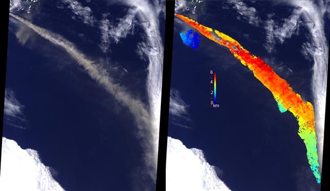
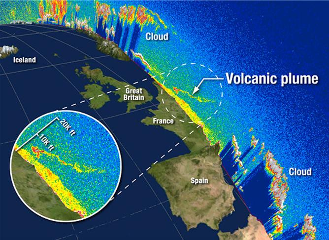
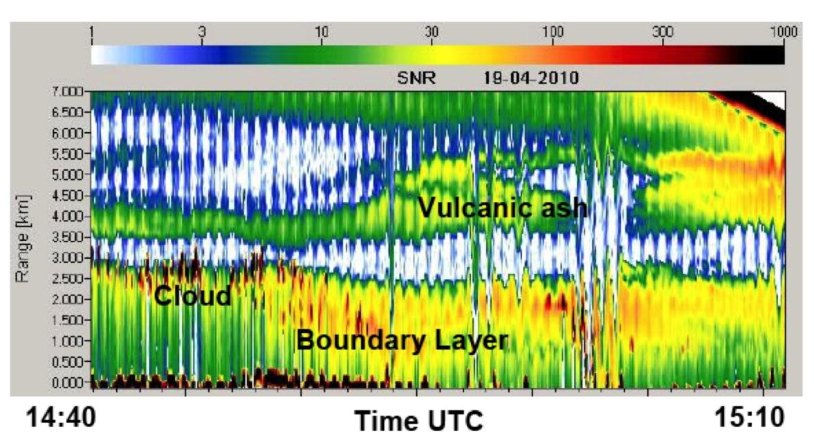
nd, aerosol scientists from NASA’s Goddard Space Flight Center and neighboring institutions met last month at a special AEROCENTER seminar to share information about some aspects of Eyjafjallajökull’s plume that they’ve studied so far.

Such cross-satellite and cross-platform efforts make it possible to address some of the thorniest problems in the field. Comparing results from several instruments, for example, makes it easier to understand the dispersion of plumes and—with the help of computer models—predict how plumes might behave, noted Santiago Gassó, the Goddard geophysicist who organized the seminar.

Though the scientists have just started picking their way through Eyjafjallajökull data, there are a number of presentations from the meeting to click through if you’re interested. There’s nothing Earth-shattering to report yet, but we did find some views of the plume that you likely haven’t seen in the newspapers. You can find more imagery of Eyjafjallajökull’s eruptionand plume here,here, here, here, here, here, and here.


MISR – Plume Height


NASA scientists used an instrument called MISR aboard the Terra satellite to view the ash plume from multiple angles, and then applied a stereo-imaging technique to derive the height of the ash cloud at different points during the eruption. The result is the colorful image on the right that distinguishes plume height with bright reds (6 km), oranges (5 km), yellows (4 km), greens (3 km), and blues (2 km). The blue, near-surface part of the plume is resuspended ash.  (Image Credit: NASA/JPL/MISR)


CALIPSO – Vertical Profile

The CALIPSO satellite provides a vertical profile of a whole slice of the atmosphere with a LIDAR instrument that shoots laser pulses at the atmosphere below and measures how it reflects off particles in the atmosphere. In this image, captured on April 17 as the satellite passed over France, the plume appears as a wispy band of yellow and red. The thick yellow layer below is air pollution hovering near the surface of France. (Image Credit: NASA/CALIPSO/Winker)


OMI – Sulfur Dioxide (SO
2)


The Ozone Monitoring Instrument (OMI) aboard NASA’s Aura satellite had eyes for ash as well as something that’s invisible to the human eye: the transparent (and toxic) gas sulfur dioxide (SO2). OMI observed sulfur dioxide billowing out of the volcano at a clip of as much as 10 thousand tons a day. The OMI instrument produced this image, which shows higher concentrations of sulfur dioxide in red and lower concentrations in blue and purple, on April 30—two weeks after the peak of Eyjafjallajökull’s eruption between April 14 and 17. (Image Credit: NASA/OMI/via Joiner)


DLR Falcon – Aircraft LIDAR


A few days after the eruption began, European scientists scrambled a DLR Falcon jet equipped with a LIDAR and other instruments. The LIDAR, cruising at 8 km altitude, detected volcanic ash in the altitude range of 3.5 km to 5.5 km. The ash plume appears as a yellow and green mass above a layer of clouds (seen as the line of rust-colored spots beneath the ash). When the instrument collected this data, the ash had aged four or five days. The white streaks on the image represent areas where the LIDAR did not detect a significant amount of aerosol. (Image Credit: DLR/via Diehl)

— Adam Voiland, NASA’s Earth Science News Team

Earth Day Extravaganza on the National Mall

Earth Day is still a day away, but already NASA’s exhibit on the National Mall is brimming with activity. On April 17, NASA’s Earth Science Division deputy director Jack Kaye kicked off the festivities by cutting the ribbon on the NASA Village. Here’s just a sampling (and full schedule of events) of what you might find if you come to Washington, DC:

An igloo-shaped tent with a striking resemblance to the Northern Hemisphere (Credit: NASA/Barker) 

Violinist Kenji Williams accompanied by awe-inspiring satellite imagery(Credit:NASA/Chrissotimos)


Puzzle-mania (for all ages) (Credit: NASA/Barker)

Thought-provoking talks about Earth science from leading scientists (That’s Goddard’s Compton Tucker discussing the ocean.) (Credit:NASA/Chrissotimos)
 

A space suit with your name on it (Credit:NASA/Chrissotimos)
 

Stuck at home? No worries. NASA is all over on the web as well. You can take part in this online chat about climate change on April 22nd. And there’s a number of NASA missions and websites—ranging from the NASA Earth Observatory to Earth Vital Signs to NASA Glory to NASA IceBridge–that are always aTwitter with Earth science.

— Adam Voiland, NASA’s Earth Science News Team