Listen to the Sound of a Ship's Hull Gouging Through First-Year Ice

What on Earth was that grinding, thudding, scraping sound? No, it wasn’t astronauts clumping around on the Space Station, a washing machine in the midst of a cycle, or space dust hammering the Space Shuttle. It was actually the Coast Guard’s newest and most technologically advanced ice breaker — the Healy — barreling through thin, first-year ice in the Chukchi Sea north of Alaska. (Multiyear ice tends to be less briny and have more air bubbles than first-year ice.) NASA science writer Kathryn Hansen is on board as part of the ICESCAPE mission, and she had this to say about the sound:

On July 7, I took a trip down into the bowels of the Healy’s bow to record the sound of the ship’s hull pummeling through thin, first-year ice (mp3 above). The rhythm and crescendos reminded me of the percussion section of an amateur orchestra.

Interestingly, icebreaking sounds completely different depending on your location in the ship. From outside on the ship’s deck you can hear the ice cracking and ocean water rushing in to fill the void. From inside in the science lounge, add the effect of vibrating bookshelves and the demise of items not properly secured.

These sounds (not to mention the earthquake-like movement) eventually blend into the background and sleep comes easily. The strange part will be returning home at the end of the month to a “quiet and still” life in the city.

By now you might be wondering, how much ice can the Healy break? Cruising at 3 knots, the ship is rated to break 4.5 feet of ice. By backing and ramming, the ship can break through 8 feet. Breaking thicker ice is possible but would take more time.

Hansen has also filed a few web videos about the expedition featuring interviews with ICESCAPE Project Scientist Kevin Arrigo and Karen Frey of Clark University that are worth checking out.

Has the Arctic Gotten Sootier Over the Last Century?

Black carbon, the sooty particle that gives smoke from diesel engines and cooking fires a dark appearance, took center stage this week when Secretary of State Hillary Clinton attended a high-profile meeting of the Arctic Council in Nuuk, the capital of Greenland.

Black carbon has attracted the attention of climatologists and policy makers alike because its complex structure makes it so good at absorbing sunlight. To make this point, University of Illinois-based Tami Bond, one of the nation’s leading black carbon specialists, noted during a Congressional hearing last year that one ounce of black carbon dispersed in the atmosphere would block the amount of sunlight that would fall on a tennis court. The absorbed energy then gets transferred to the atmosphere as heat and contributes to global warming.

The Arctic Council meeting coincided with the release of two scientific reports focused on the cryosphere. The first, authored by the scientific arm of the Arctic Council, argued that the United Nations underestimated the rate at which the Arctic is losing sea ice and concluded the Arctic Ocean could be ice-free within the next thirty to forty years. The second makes the case that it’s possible to cut Arctic ice loss significantly by curbing black carbon emissions.

I’ve written before about the possibility that reducing black carbon emissions could save Arctic Sea ice. Recent modeling, conducted by Stanford’s Mark Jacobson and funded in-part by NASA, suggests that eliminating soot emissions from fossil fuel and biofuel burning over the next fifteen years could reduce Arctic warming by up to 1.7 °C (3 °F). (Net warming in the Arctic, in comparison, has been about 2.5 °C (4.5 °F) over the last century.

Future emissions aside, what has actually been happening with black carbon deposition trends in the Arctic? Have black carbon emissions, like carbon dioxide emissions, been going steadily up in recent decades?

A recent report, authored by climatologists at NASA’s Goddard Institute for Space Studies, offers a nice overview that I’ve excerpted below. It may come as a surprise that the amount of black carbon winds are dumping on Arctic ice has actually fallen over the last few decades. From the GISS study:

Recently there has been concern about impacts of black carbon on snow albedo in the Arctic and whether that has contributed to melting of Arctic sea-ice and snow. Some studies have focused on changes in Arctic BC since the 1980s when measurements were first made. Sharma et al. (2004) found a 60% decrease in atmospheric black carbon at Alert between 1989 and 2002. Recent Arctic snow measurements (e.g. Grenfell et al., 2009; Hegg et al., 2009) found BC concentrations to be about 5-15 ng g−1 in Canada, Alaska and the Arctic Ocean, about a factor of two lower than measured in the 1980s (e.g. Clarke and Noone, 1985). Contemporary Russian measurements are larger than the western Arctic, ranging from about 15-80 ng g−1, while BC concentrations in the Barants and Kara seas were measured at about 15-25 ng g−1 (Grenfell et al., 2009; Hegg et al., 2009). The Greenland ice sheet has relatively very low BC levels, about 2-3 ng g−1, similar to the measurements in the 1980s (Grenfell et al., 2009).

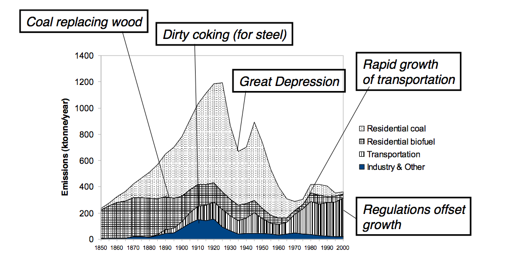
Bond showed some particularly helpful graphs during her testimony last year that give long-term emission trends. According to Bond’s estimates, black carbon emissions peaked around the turn of the century when dirty cooking stoves were common.

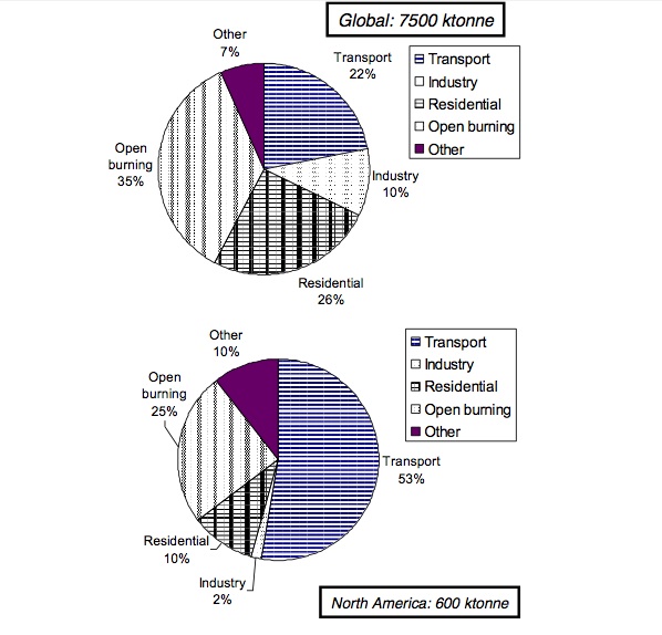
She also has showed a good graph that shows the sectors that produce the most black carbon.

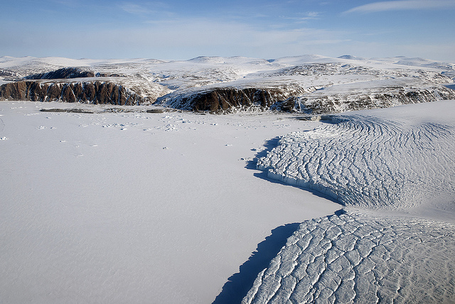
Text by Adam Voiland. Image of Pitufkin Glacier in Greenland from NASA’s IceBridge Mission. Graphs from Tami Bond. 

Why Cutting Black Carbon Emissions May Save Arctic Sea Ice

Arctic sea ice is retreating at an unexpectedly rapid pace. Average ice extent in September has declined by 11.5 percent per decade relative to the 1979 to 2000 average, according to satellite measurements of the ice. Many climatologists expect that the Arctic will be ice-free during the summer in as few as thirty years if current trends continue.

Most scientists who study the issue closely agree that reducing carbon dioxide emissions is the key to stabilizing Earth’s climate. However, even if nations began curbing emissions immediately the world would continue to warm for many decades. While Earth can reabsorb some portion of carbon dioxide emissions fairly rapidly, a significant amount of carbon will remain in the atmosphere for long periods. Some 20 percent of carbon dioxide emissions are expected to remain in the atmosphere for tens of thousands of years, according to some estimates.

That doesn’t bode well for the dwindling Arctic sea ice.

However, if Mark Jacobson, an atmospheric scientist from Stanford University is right, there may still be hope for Arctic sea ice and the ecosystem it supports. Jacobson studies the climate effects of tiny airborne particles called black carbon, a scientific term for soot, the black stuff in smoke. Wood, dried animal dung, and other biofuels all produce black carbon when burned.  And fossil fuels, such as coal and petroleum, are especially prolific producers of the particles.

Under a microscope, black carbon is an amorphously-shaped particle with a branching globular shape. What’s most notable about black carbon, however, is the many ways that it can warm the climate. Black carbon particles, which unsurprisingly tend to be a coal black color, warm the air directly by absorbing sunlight and converting it into infrared radiation. They also reduce the reflectivity of the surface when deposited on icy surfaces. And they infiltrate cloud droplets in ways that can cause clouds to dissipate more quickly than they otherwise might.

Together such effects can produce a potent warming effect. Last week, during a session focused on black carbon at the American Geophysical Union meeting in San Francisco, Jacobson reminded meeting attendees of a bit of news that Stanford released a few months back. Reducing soot emissions may be the fastest method – indeed the only way — of saving the Arctic ice, Jacobson noted. “On average black carbon particles stay in the air for just four or five days, so reducing emissions has an immediate impact,” he said in an interview later. “That’s not the case for greenhouse gases.”

Recent modeling, conducted by Jacobson and funded in-part by NASA, suggests that eliminating soot emissions from fossil fuel and biofuel burning over the next fifteen years could reduce Arctic warming by up to 1.7 °C (3 °F). Net warming in the Arctic, in comparison, has been about 2.5 °C (4.5 °F) over the last century.


–Adam Voiland, NASA’s Earth Science News Team

What to Expect from the Arctic

Guest science writer KarenRomano Young reports from the ICESCAPEmission:

The U.S. Coast Guard Cutter Healy, our chunky red-and-white icebreaker, sits at the gates of the Arctic Ocean. In the wee hours this morning, the sun set and quickly rose again, and a rainbow stretched up into low clouds. The ICESCAPE mission had reached station 5 of a seven-stop transect of the Bering Strait, between Fairway Rock — resembling Kong Island, but with pointy ears — and Little Diomede (U.S.) — something like the “Cliffs of Insanity” in The Princess Bride. Close by is Big Diomede (Russia), topped with fog.

Movie references aside, this is a dramatic spot in which to find yourself when you wake up in the morning — or in the evening, as is the case for the half of the science crew working the night shift to process the samples.

It seems that no matter how many times a scientist has been to sea, it doesn’t get old. Greg Mitchell (below right), a specialist in ocean optics from the Scripps Institution of Oceanography, reckons he has spent about four years of his life aboard ships. His first trip to the Arctic was in 1987, his first year at Scripps. Mitchell’s research has taken him all over the world — to Antarctica and back again many times — but he hasn’t been inside the Arctic Circle since 1989. He expects change. Greg Mitchell

Observing the system…..and how it interacts with the edge of the sea ice…..and what’s going on with the ice melt…..and how it affects the ocean…..those principles won’t be any different than they were 20 years ago. “What we’re clearly seeing is that the sea ice is reducing more and more all the time,” said Mitchell. “This means less sunshine reflecting off the ice back into space, and more getting into the ocean.”

He expects the increase in sun-light on the sea to do three things:

  • “The light that’s not reflected will heat the ocean, accelerating the warming and accelerating the melting of the sea ice.”
  • “As the ocean warms it becomes more stratified. If you dive in a lake in the summertime, it’s warmer at the surface. But as you dive down, you feel the cold. That’s because the warm water is lighter than the cold water, and it stays at the surface. That’s thermal stratification. As you warm the ocean, it’ll stratify more and that will create a warm layer with a lot of light for algae to bloom (as long as they have nutrients).”
  • “More light in the ocean should cause more total photosynthesis in the Arctic, so we’ll lose habitat for polar bears but we’ll gain habitat for plankton.”

Like the rest of us, Mitchell is concerned about that. “I’m not saying it’s a good trade off. I think we should leave things alone. But the system’s changing, and as it changes we don’t know what the consequences of those changes will be. It’s hard to say what we could do. What we really need to do is to find a way for humans to have smaller footprint on earth. So we need to understand the processes better and then we need to model it.”

That’s why he’s here.

Mitchell, along with his group from Scripps, is involved in ground-truthing the optical properties of the Arctic Ocean (photos at the top and bottom of this post). That is, he’s helping to ensure that what they see at the surface squares up with the methods NASA satellites use to assess ocean color, an indicator of the level of chlorophyll and, by proxy, phytoplankton. NASA’s satellites measure the color of the ocean by flying over the earth and picking up blue, blue green, and green. If there’s not a lot of algae, the ocean is blue. If there is a lot of algae, the ocean is green.

But color is just one way of looking at phytoplankton levels. In order to truly assess the situation — for example how much carbon dioxide the phytoplankton are taking in – scientists need to assess the processes at work in the sea. “The optics don’t tell us this, so we have to take water samples, process the water, and then relate that to the optics we measure from the ship,” Mitchell said.

The global mapping you can see on the NASA site uses mathematical equations developed from the shipboard work. Satellite validation and calibration is based on the findings of scientists who go to sea and study the water to see what’s living there. Mitchell’s research group claims responsibility for about 20 percent of the global observations used by NASA for their models to convert satellite-measured optical measurements to chlorophyll estimates.

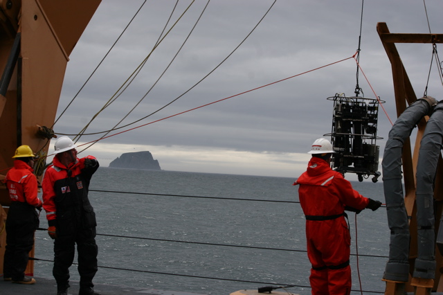
lowering gear from the Healy

The data contributes to models that allow prediction of primary production — the growth and health of organisms — under various conditions. Mitchell’s instruments include a small optical profiler — a fish-shaped instrument lowered from the Healy’s bow — and an optical package of instruments that measure water properties when it is lowered from the powerful A-frame at the stern.

“As ecologists, we don’t want to just know what color the ocean is,” he said. “We want to know how much plankton there is.” He walks to the edge of the ship and looks over the rail. “Now what we’re seeing out here is green water. There’s a lot of chlorophyll.” That means a strong pulse of phytoplankton, busy photosynthesizing the extra sunlight.

All photos shot by and courtesy of Karen Romano Young

Puzzling Over the Pieces

Guest contributor Karen Romano Young (photo at right) blogs from NASA’s ICESCAPE expedition…

There’s a sign on the door of the room I share with Sharmila Pal and Emily Peacock. It’s a green square of plastic engraved with a picture of a polar bear and the words “SCIENCE – LATE SLEEPER.” So many of the scientists aboard Coast Guard Cutter Healy for the ICESCAPE mission are awake through the night that the ship’s engraver, Chief Warrant Officer 3 Sean Lyons, has turned out a special  edition of late sleeper signs, complete with a rocket ship for NASA. Almost every door boasts a sleeper sign of one kind or another.

The reason? Aboard ICESCAPE, the science goes on 24 hours a day. We’re on a path to the far north, steaming from station to station through the night. Sometimes we’re in ice, sometimes we’re in open ocean, sometimes there’s a mix. Sometimes, there are walruses and seals. Each group of scientists has divided their schedule into shifts, so while some are catching their zzz’s behind those “late sleeper” signs, others are awake and overseeing operations, making measurements, and processing samples.

NASA’s Stanford Hooker takes the small boat out to measure light and take water samples, away from the interference of the ship. Karen Frey’s group from Clark University works on ice stations and takes Van Veen grabs in the open sea. (It’s like a giant pooper-scooper that scoops sediment from the ocean floor).

Bob Pickart of the Woods Hole Oceanographic Institution works to assess currents and other elements of physical oceanography, such as eddies and upwelling, as we pass through the ocean. James Swift, from Scripps Institution of Oceanography, oversees the CTD, a rosette of siphons and bottles triggered to sample water at various depths. (CTD stands for conductivity, temperature, and depth.) Greg Mitchell, Rick Reynolds, and their groups from Scripps measure the ocean’s optical properties with a small profiler dropped from the bow and with the Inherent Optical Properties (IOP) package of instruments deployed from the stern.


Sketch by Karen Romano Young

“We’re all working on different pieces of the same puzzle,” Reynolds says. “It’s impossible for one group to measure all we need to know. [Chief Scientist] Kevin Arrigo’s group is looking at core pigments, the plant pigments in the water column. Others are looking at chemical analyses of the nutrients in the water. It’s a big team effort. The ice people are working in a completely different environment, but there are algae in both places.”

The $250,000 IOP suite of instruments assesses the health of the ocean by analyzing the absorption and scattering of light by particles suspended in the water, including chlorophyll-rich algae; the quantity and quality of algae (the health and growth rate); and the presence of minerals and sediment. Each instrument on the IOP contributes to a picture of the makeup of the particles by assessing changes in light transmission.

“We start at the top,” says Reynolds (shown at left). “We look at what the NASAsatellite sees — the sea color — and parse out the differentcharacteristics of the water — how much algae, and what else is there,such as minerals from rivers, re-suspended sediment (mud stirred intothe water) and melting ice.” The resulting data will help thescientists develop new algorithms — equations for solving problems –to support the satellites.

NASA ice- and ocean-observing satellites, now working for more than ten years, are beginning to allow us to examine changes in the climate. One purpose of ICESCAPE is to look at the ocean with greater detail than the satellites offer, in order to improve and refine the interpretation of the satellite data. 

“We’re here because NASA wants to know what the satellites are seeing right here at the stations,” says Reynolds, “where nobody else may sample for decades, because the ocean is so vast.”

All imagery, including the IOP sketch, courtesy of Karen Romano Young 

Plankton on Parade

This is the last of four dispatches from guest writer Karen Romano Young. She spent time on the ICESCAPE expedition

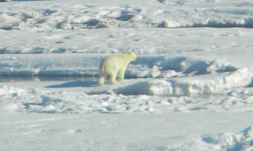
The hypothesis has been proved conclusively aboard the Coast Guard Cutter Healy: I can officially sleep through anything. Yesterday [June 26] we hit what chief scientist Kevin Arrigo calls the heavy ice, northwest of Point Barrow, the northernmost point in the United States. Almost immediately we spotted a polar (right) bear, but haven’t seen one since. You can’t blame them for staying away from the Healy as it slams its 16,000 tons — plus the combined weight of everyone who spent the day eating the chocolate croissants Emily Peacock baked — into the ice.

Early this morning, the ice scientists stood on the bridge and targeted a floe for an “ice station.” For nine hours, we tried to get to it. Slowly and steadily, the ship made a path, ramming, cracking, or backing and ramming again, and the chopped-up ice in our wake soon froze together behind us. Scientist Sam Laney wishes he had a computer application that would detect seismic disturbances, saying he has lived through earthquakes registering 5.5 on the Richter scale and the vibrations didn’t feel as strong as they do right now.

[Laney commented later: “I actually downloaded a program last night and took a few hours of measurements in the aft hose reel room. I am not a seismologist, of course, but I’m estimating between 4.3 and 4.9 on the Richter scale based on these crude measurements.” This is why I like to hang out with scientists. ]

You can see the ice on a map compiled from satellite data, but the reality of the sea ice is right here at sea level. It’s quite different thing to see it in a satellite image as opposed to falling over in the shower because your ship is tilting as it climbs a ridge of jammed-together ice floes and slides back down.

The sea ice measurements made by a dozen scientists on the ice for our station will help confirm details in the satellite maps, just as the work of those studying optics in the open sea will add to the sea color (chlorophyll) mapping that NASA does.

But there is an additional method of observing the Arctic Ocean that I’d like to tell you about because it has been so exciting to everyone here at ICESCAPE. You don’t have to interpret maps or charts of data. You just have to sit back, put your feet up, and check out Sam Laney’s pictures.

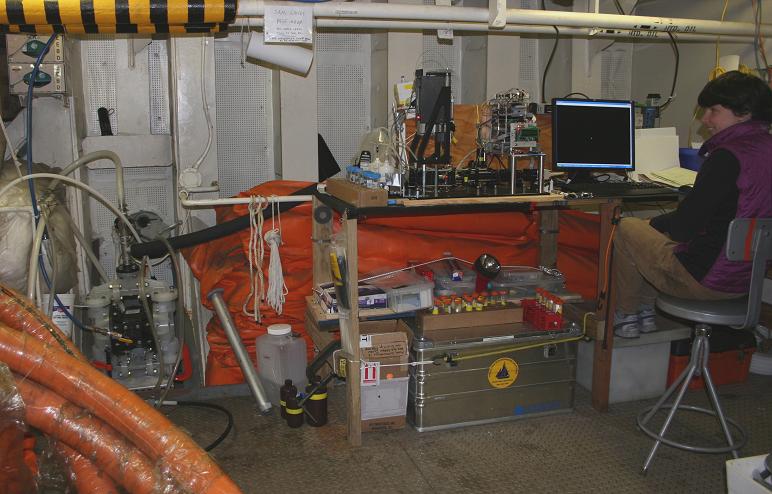
Sam’s images come from a stream of water coming up through a hose at Healy’s stern. All the microscopic organisms in the stream parade in front of a camera, sitting briefly for a snapshot before returning to the sea. The instrument, which is set up deep below in the aft hose reel room, is called the Imaging FlowCytobot (below right). It was developed at the Woods Hole Oceanographic Institution.
Flow cytometry has long been used in medicine for counting cells — such as platelets – in blood samples as they are squirted past a laser. Oceanographers use flow cytometers to count the small cells that live in seawater, such as phytoplankton (photosynthetic microbes) and other small organisms. 

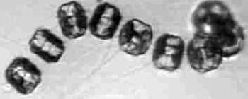
Imaging flow cytometry takes this approach one step further by triggering a camera every time a cell passes in front of the laser beam. Software on the imager immediately crops out the background from the picture to focus on the critter that was just photo-graphed. The revolutionary result is a steady flow of pictures of organisms as small as 2 microns living in seawater. It looks like a case of jewels: individual round-bodied gems, bigger broach-like diatoms chains (above right), and monster-like ciliates that prey on the smaller critters. 

In the past, scientists were able to gather steady flows of water and videotape the plankton at magnification. But managing this huge amount of data would have taken such incredible man-hours that it was impractical for use at sea. The Imaging FlowCytobot does it for us, snapping off a continuous stream of pictures — as many as ten thou-sand cells in a volume of seawater no bigger than a AA battery

Laney’s sea-going imager is an outgrowth of an underwater Imaging FlowCytobot that his collaborators Heidi Sosik and Rob Olson have operated for several years at the Martha’ Vineyard Coastal Observatory off Massachusetts. ICESCAPE is the first time the instrument has been used at sea to survey broad regions of the ocean.
“We are seeing what’s in the water immediately, not after the fact in a lab,” Laney explained, “so it’s obvious when the water — and what’s in it — changes. In the images taken north of Dutch Harbor, there weren’t many cells out there because it’s the open ocean. But in the Bering Strait, the jewels were much more elaborate because we were closer to shore. A large diatom chain indicates an ecosystem that has a lot of nutrients and is highly productive.”

Laney, Sosik, and Olson hope to see Imaging FlowCytobots placed aboard long-term, deep-ocean moorings in the open sea, such as those that will be deployed as part of the Ocean Observing System.

Of course, some of the fun is just seeing the plankton in action. Sometimes you can simply tell that they’re ailing or dying. In one memorable stretch of sea, off Point Lay, the Cytobot caught a stream of diatoms in the act of dividing and reproducing. Then there are the horror shots, in which a ciliate stretches its cilia toward a hapless phytoplankton.

Imagery courtesy of Karen Romano Young. The polar bear was photographed by Gert van Dijken. 
Beautiful Radiance

Karen Romano Young (right), a freelance writer and illustrator embedded with NASA’s ICESCAPE field campaign, sent this report from an icebreaker headed to the Arctic. You can follow the expedition on the ICESCAPE blog

Here on the U.S. Coast Guard Cutter Healy, heading north toward sampling stations in the Bering Strait, there’s plenty of light — a beautiful radiance nearly around the clock. Since arriving in Alaska on June 12, I’ve only awakened once in the middle of the night to find it dark. Last night at nearly 11 p.m., I sat drinking tea in front of my porthole, and saw a rainbow descend between strips of clouds into the grey Bering Sea. We’re in the land of the midnight sun, and as we continue north the night light will grow longer. It’s the opposite of the conditions that lead to Seasonal Affective Disorder down south where I come from (Connecticut!) For me, it’s joy.

Up here where there used to be more ice, the radiance is, well, radiating. This is the key: the Arctic ice reflects sunlight back into space. If there’s no ice, the sunlight goes into the water, warming it, and creating an environment in which phytoplankton — tiny plantlike algae at the water’s surface — can thrive. There’s less ice because our atmosphere is trapping greenhouse gases — carbon dioxide and methane — and the result is a warming Arctic.

Many of the 40-plus scientists participating in ICESCAPE, a NASA-led research cruise, are involved in studying the effects of sunlight. ICESCAPE stands for Impacts of Climate Change on the Eco-System of the Arctic Pacific Environment, and its purpose is to bring ice scientists and ocean scientists together to gather a greater understanding of the conditions in the Bering, Chukchi, and Beaufort Seas.

Who better to begin a discussion of the sun’s warming effects than a University of Washington scientist named Bonnie Light? Light has been working in the Arctic Ocean since 1998 when, as a grad student, she boarded the Canadian icebreaker Des Grosseilliers, which had purposely pulled up to the edge of the 1997 autumn ice and got fro-zen in through the 1998 thaw. That was the SHEBA (Surface Heat Budget of the Arctic) project, designed to increase understanding of the Arctic system.

Getting frozen in to the ice was a nod to the so-called “father of Arctic science,” Fridtjof Nansen, who purposely did the same a century earlier to prove his theory that the ice cap drifted. One of the purposes of SHEBA was to provide a baseline for under-standing Arctic conditions that might be affected by global warming. Several other scientists aboard ICESCAPE also participated in SHEBA, including Bonnie’s group leader and co-chief scientist Don Perovich.

The flight to the SHEBA site from Barrow, Alaska — the northernmost city in the United States — was the first time Light saw sea ice. “I’d calculated the total square kilometers that the Arctic ice cap occupies many, many times,” she said, “but to be in a little air-plane and fly over it and just see it…this endless stretch of pack ice was really striking.” During the ICESCAPE cruise she is eager to explore the western coast of Alaska for the first time.

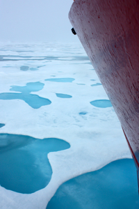
“People have told me that the sea ice in the Chukchi Sea has already begun to open up and is very loose this year,” Light says. She expects to be one of the “ice party,” the group of scientists that descends from the deck of the Healy (shown left), via a basket dangling from a crane, to work on the ice. “I don’t know if we’ll get out on it or not. We’ll have to just wait and see what it looks like when we get there. It’s something I’m not sure a satellite can tell you.”

Light is interested in the physics of solar irradiance – what happens to the sun’s light in ice on a small-scale, but also at the larger scale of the melt ponds that form atop sea ice. One of the experiments she’ll conduct involves a comparison of how sun radiates through bare ice and ice that has a melt pond on top. “We already know that melt ponds make really good skylights,” she says. But could they accelerate melting of already-melting ice, hastening the tipping point between ice cover and open sea? Bonnie Light’s ICESCAPE experience could tell.

Image Information: Courtesy of the U.S. Coast Guard (bottom left) and Karen Romano Young (top right).

NASA Readies for Spring 2010 Ice Bridge Campaign

The following is a cross-post from our sister blog at NASA’s Operation Ice Bridge. For more frequent updates on the Ice Bridge mission, visit https://www.nasa.gov/topics/earth/features/ice_bridge/index.html

Credit: John Sonntag/Wallops Flight Facility

In August 2008, NASA scientist John Sonntag, of NASA’s Wallops Flight Facility in Wallops Island, Va., captured this view of a small iceberg as it moved down the Narsarsuaq fjord in southern Greenland. “I spent about half an hour watching that little berg, which was in the process of disintegrating during the time I was watching,” Sonntag said. “It went from a complete, small berg to a collection of floating ice rubble within that small span of time. The place was so quiet that the noise of the berg softly coming apart was the only sound present.”

Sonntag’s observation took place during the 2008 NASA and Center for Remote Sensing of Ice Sheets (CReSIS) airborne deployment in Greenland. This spring, Sonntag and other scientists return to the Arctic for big picture and little picture views of the ice as part of NASA’s six-year Operation Ice Bridge mission — the largest airborne survey of Earth’s polar ice ever flown — now entering its second year. The project team is finalizing flight paths over Greenland’s ice sheet and surrounding sea ice, where scientists will collect measurements, maps and images from a suite of airborne instruments. Such information will help scientists extend the record of changes to the ice previously observed by NASA’s Ice, Cloud, and land Elevation Satellite (ICESat), while uncovering new details about land-water-ice dynamics.

NASA aircraft have made numerous science flights over Greenland, most recently during the spring 2009 Ice Bridge campaign and also in 2008 as part of the NASA/CReSIS deployment. Smaller-scale airborne surveys have been made by William Krabill, of NASA Wallops, and colleagues nearly every spring since 1991.

Visit the Operation Ice Bridge Web page throughout the spring 2010 campaign for news, images, and updates from the field. Flights from Greenland are scheduled to begin no sooner than March 22.

— Kathryn Hansen, NASA’s Earth Science News Team

An Award-Winning Scientist Who Came in from the Cold


NASA-funded researcher Ben Smith digs a snow pit at a West Antarctic Ice Sheet Divide core
site to try to infer the annual rate of snowfall. Credit: Ben Smith

Researchers who study glaciers and polar dynamics often get into it for the love of the field work — the challenging terrain, technicological adventures, and thigh-deep snow.

Benjamin Smith, a researcher at the Polar Science Center at the University of Washington’s Applied Physics Laboratory, was no exception. As a fledgling physicist in the 1990s, his first summer job after college turned into an eye-opening adventure — a 3-month stint at the Kamb Ice Stream in Antarctica as a field assistant mapping buried crevasses with snow-penetrating radar. The rest, as they say, was history.

These days, Smith is enjoying a rare honor as one of two NASA-supported researchers to receive the Presidential Early Career Award for Scientists and Engineers (PECASE), awarded at a White House ceremony last month.

WhatOnEarth: Field work was your entry into studying glaciers. Are you involved  in Arctic or Antarctic field work now?

Smith: After a few years of field work, I discovered that though being out in cold is great, the quicker way to learn about glacier change is by doing remote sensing work. That requires a great deal of data analysis indoors. So with that notion, I got onboard as part of NASA’s ICESat I mission while working on my doctorate in physics.

WhatOnEarth: What work do you believe was the basis for your presidential award?

Smith: Well, I have a few projects that I’ve been fortunate enough to be involved in.

Not too long ago, I wrote a paper where we found that several lakes beneath the glaciers in Antarctica have gained or lost water in the last five years, and at a rate much faster than things usually happen in Antarctica. We’ve been seeing lakes that fill or drain in half a year. In one case, 3 cubic kilometers of water drained last year from one of these lakes. That’s about the size of Lake Washington in Seattle.

My main objective in all of this is to figure out where that water went and how it has affected other subglacial lakes and glaciers downstream. Have those glaciers sped up from the water flowing under them? The warmth of the surface bed beneath glaciers allows them to slide faster. If you add more water, there’s potential for glaciers to slide faster. 

I’m also part of a team that is helping to design the ICESat II satellite – a project we hope will build on the success of ICESat I. The satellite will boast several laser beams rather than one, so it’ll provide much better spatial coverage of the Earth’s surface to measure glacier mass and area.

 
President Obama honored PECASE awardees, including Ben Smith and Josh Willis, in January at the White House.
Credit: The White House


WhatOnEarth: Were you aware that you’d been nominated for the PECASE award?

Smith: No. I was completely unaware of it until I was notified by the FBI about a background check! I can tell you I was relieved when I found out the background check regarded my visit to the White House. I understand now that my nomination was put forward by colleagues at NASA. Somehow, my nomination came out on top of the pile, and that’s pretty cool.

To read a few of Ben Smith’s ICESat-related scientific papers, click the topics below.

Ice stream elevation changes observed by ICESat

Increased flow speed on an East Antarctic glacier

An inventory of subglacial lakes detected by ICESat

Gretchen Cook-Anderson, NASA’s Earth Science News Team