An Active Arctic: Where Sea Ice Meets the Midnight Sun

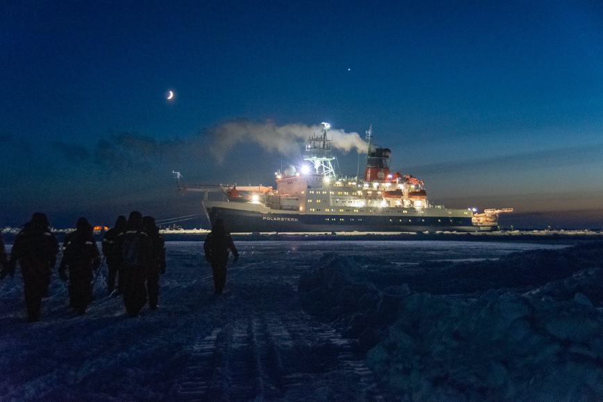
The German icebreaker Polarstern lit up on every deck, acting as a beacon for researchers navigating the Arctic terrain. Credit: University of Maryland / Steven Fons

By Emily Fischer, Goddard Space Flight Center

In the early 1900s, Ernest Shackleton attempted to travel across Antarctica, but as they neared the continent his ship became stuck in an pack of sea ice and was slowly crushed before it reached the landmass. Over 100 years later and on the opposite side of the globe in the Arctic, researchers in the massive, double-hulled icebreaker, Polarstern, are also stuck in a pack of sea ice – but this time on purpose. And this ship isn’t sinking any time soon.

Polarstern is the operational center for the Multidisciplinary drifting Observatory for the Study of Arctic Climate, or MOSAiC. The first expedition of its kind, MOSAiC is an international mission exploring the Arctic climate system year-round, with more than 100 scientists and crew members from 20 nations living aboard the research vessel.

Intentionally trapping itself in the sea ice, Polarstern drifts with the floe, which is a large pack of floating sea ice. Researchers set up “little cities” on the ice where they take measurements using delicate instruments. While it appears that the sea ice they walk on to reach these camps is stationary, everything is actually slowly drifting as wind and ocean currents push the gigantic slabs of ice.
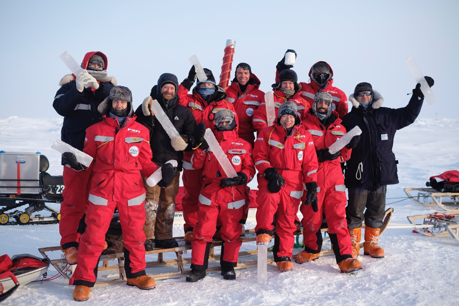
Steven Fons (bottom row, second from the right) and his ice coring team after successfully drilling sea ice samples. Each core will be analyzed at the labs aboard Polarstern. Credit: University Center in Svalbard / Calle Schönning

MOSAiC is a multidisciplinary expedition, as researchers from a variety of fields – including marine biology, meteorology, and oceanography – collaboratively study Arctic changes.

“It’s more of a process study,” explained Steven Fons, a Ph.D. candidate at the University of Maryland and NASA’s Goddard Space Flight Center, who studied sea ice from March to May of this year. “The idea, then, is once everybody collects this data, we can compile everything and learn about the sea ice in the ocean, and the atmosphere and the ecology.”

Sea ice is an integral part of the Arctic climate system because it sits directly between the ocean and the atmosphere, moderating the exchange of heat and moisture. An important climate indicator, sea ice research identifies changes in other Arctic climate systems, including the ocean, atmosphere, ecology, and biogeochemical cycles. Basically, studying sea ice can give greater insight into how the entire Arctic is reacting to climate change.
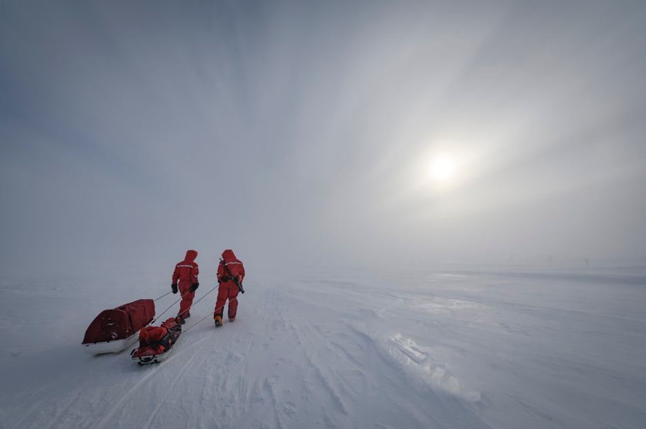
Researchers haul their equipment to their field sites through snow blown by harsh winds. One researcher, a polar bear guard, carries a rifle on his back in case of an emergency. Credit: Alfred Wegener Institute / Delphin Rouché

For a small group of MOSAiC researchers, every Monday was a 14-hour workday spent at “Dark Sites,” named so because they are isolated from the bright lights of Polarstern. After traveling over a mile on snow machine, the team used hollow drills to remove cylindric cores from the sea ice floe. In the labs aboard Polarstern, these samples revealed the fascinating characteristics of sea ice.

“As ice forms, it will eject the salt away as it’s freezing,” said Fons. “The longer it stays around, the more salt essentially drains out of it.” Basically, high salt levels tell researchers that this particular ice formed in the most recent winter. This can reveal how the Arctic adjusts to higher temperatures, as the region is warming at a rate more than twice the global average.

In the Arctic, wind chill can reach frigid temperatures as low as minus 70 degrees Fahrenheit. Working in the cold without hand protection was impossible, so Fons wore thin gloves underneath his bulky mittens, which he removed when handling small objects. Even so, frequent warming breaks were necessary, which meant simple, one-minute tasks could take 10 times longer in Arctic conditions.

“Some of the really cold days, you can only last 30 seconds at a time taking off your big mittens,” he recounted. “You just have to put five zip ties on this cable, perfect. It should take one minute to do, but it would take 20 minutes because you have to keep warming your hands and [the zip ties] keep breaking in the cold.”

Native to Wisconsin, Fons is no stranger to subzero winters. Nonetheless, during this expedition he witnessed temperatures unlike anything he had ever experienced before. Icy winds bit into any exposed skin. His only relief: a thick, bushy beard and about ten layers of clothing.
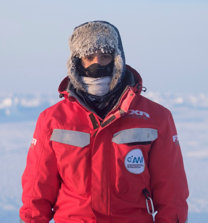
Steven Fons bundles up in the subzero temperatures with a fur-lined hat, multiple face-coverings, and nine or ten layers underneath his protective jacket. Credit: University Center in Svalbard / Calle Schönning

In an ever-changing environment, researchers’ locations can be difficult to determine on the ice cover, which can literally shift beneath their feet. For MOSAiC, every measurement is paired with a GPS coordinate. However, the ice drifts, and so the latitude and longitude change every day. Instead, the immense icebreaker Polarstern is used as a point of reference, a sort of ground zero for field navigation.

“You’re given a position away from the ship, so a certain distance of x and y, and that will theoretically never change,” Fons explained. But even this system has its obstacles. “If the ice broke up and the ship moves a little bit, then you can lose your x-y positions, so it didn’t always work.”

Helicopters and planes accompany Polarstern, getting a birds-eye view of the stark white landscape. Flying high above the floe, planes take airborne measurements in a similar way to Operation IceBridge. Fons does research using data from NASA’s ICESat-2 – the satellite that surveys glaciers and sea ice around the globe – and he was lucky enough to validate some of the satellite’s measurements while researching with MOSAiC.

“On the ship, since we’re constantly drifting with the ice, we don’t exactly know where we’re going to be on any given day,” he said. “We got lucky that we happened to be drifting one day over a spot that ICESat-2 was going to fly over. We were able to jump on that opportunity and schedule a helicopter flight.”

Seasonal changes near the poles are unlike anywhere else on Earth. Summer and winter are really the only seasons these regions experience, characterized by a dramatic transition between complete darkness during winter days to total sunlight during the summer. Ten days after reaching Polarstern, Fons witnessed his first Arctic sunrise. As summer came, the Sun sailed over the horizon for longer and longer each day until it refused to set, resulting in the phenomenon of the “midnight sun.”
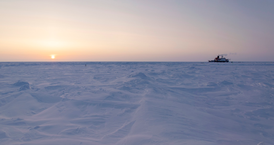
The Sun at midnight on a day when it never dipped below the horizon. The North Pole, referred to as the land of the midnight sun, experiences about five months of total darkness and about six months of never-ending sunlight. Credit: University of Maryland / Steven Fons

Ice dynamics, or the movement of ice slabs in the floe that changes the terrain, were a trademark of Fons’ three months on Polarstern. Sometimes, the researchers would wake up to massive leads, or ice fractures, blocking their usual routes. Other days, research tents would be buried in ice piles from leads that closed to form towering ridges. Sea ice dynamics had a wide appeal for study among MOSAiC teams. Below the floe, marine biologists and ecologists studied microorganisms. Within the ice itself, sea ice researchers examined crystallization patterns.

“With MOSAiC, what people are able to do is look at the ice at so many different scales and through many different lenses,” Fons summarized.
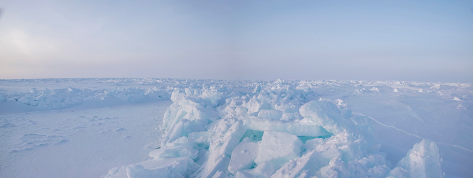
An ice lead converged to form a ridge of precariously piled slabs of ice. Credit: University of Maryland / Steven Fons


Chasing Satellites with Jacques Cousteau

acques Cousteau and his team of expert divers were a key part of the success of the 1975 NASA-Cousteau Bathymetry Experiment. In this photo from left to right: Bernard Delemotte, Chief Diver; Henri Garcia; Jean-Jérome Carcopin, and Jacques Cousteau. Photo credit: NASA
Jacques Cousteau and his team of expert divers were a key part of the success of the 1975 NASA-Cousteau Bathymetry Experiment. In this photo from left to right: Bernard Delemotte, Chief Diver; Henri Garcia; Jean-Jérome Carcopin, and Jacques Cousteau. Photo credit: The Cousteau Society (preserved as large format photo at NASA’s Goddard Space Flight Center)

By Laura Rocchio, Goddard Space Flight Center

Leaving from Nassau on a Tuesday night in August 1975, Jacques Cousteau and his team set out on the Calypso for a three-week expedition designed to help NASA determine if the young Landsat satellite mission could measure the depth of shallow ocean waters.

For days, the Calypso played leapfrog with the Landsat 1 and 2 satellites in the waters between the Bahamas and Florida. Each night, it sailed 90 nautical miles to be in position for the morning overpass of the satellite.

Ultimately, research done on the trip determined that in clear waters, with a bright seafloor, depths up to 22 meters (72 feet) could be measured by Landsat.

The primary test site for the expedition was just west of the Berry Islands on the northern edge of the Great Bahama Bank. The location was chosen as the prime testing site because it gradually changed depth from one meter to deep ocean in a short north-south span (25 nautical miles). This natural-color Landsat 8 image acquired on March 23, 2019, shows where the northern Great Bahama Bank meets the deep ocean. Image credit: NASA/USGS Landsat

This revelation gave birth to the field of satellite-derived bathymetry and enabled charts in clear water areas around the world to be revised, helping sailing vessels and deep-drafted supertankers avoid running aground on hazardous shoals or seamounts.

“It was a tremendous example of how modern tools of scientists can be put together to get a better understanding of this globe we live on,” the Deputy NASA Administrator, George Low, said of the joint Cousteau-NASA expedition in a 1976 interview.

But it couldn’t have happened without the world’s most famous aquanaut, his team of expert divers, and the Calypso.

Astronauts and Aquanauts Together

The ocean’s vastness made Cousteau an early supporter of satellite remote sensing.

Cousteau, by then a decades-long oceanographer, was keenly aware that ocean monitoring from above would be necessary to understand the ocean as part of the interconnected Earth system and to raise the awareness requisite for protecting the sea. There was a growing recognition in the 1970s that helping the planet required understanding the planet.

“Everything that happens is demonstrating the need for space technology applied to the ocean,” Cousteau said during a 1976 interview at NASA Headquarters.

George Low, the Deputy NASA Administrator, himself a recreational diver, connected Jacques Cousteau with former Apollo 9 and Skylab astronaut Russell Schweickart. Schweickart was heading up NASA’s User Services division and both he and Cousteau were looking for ways to advance Earth science.

At the time, it was theorized that the new Landsat satellites might be useful for measuring shallow ocean waters. New deep-drafted supertankers were carrying crude oil around the globe, and to avoid environmental catastrophes it had become important to know where waters in shipping lanes were less than 65 feet (20 meters).

For this experiment, Landsat data was downlinked to NASA Goddard Space Flight Center in Greenbelt, Maryland where it was processed into depth contour data. This was uplinked to the Applications Technology Satellite-3 (ATS-3) and then sent via Very High Frequency (VHF) relay to a VHF receiver system that had been installed on the Calypso for an earlier 1974 experiment in the Gulf of Mexico. Image credit: NA
For this experiment, Landsat data was downlinked to NASA Goddard Space Flight Center in Greenbelt, Maryland where it was processed into depth contour data. This was uplinked to the Applications Technology Satellite-3 (ATS-3) and then sent via Very High Frequency (VHF) relay to a VHF receiver system that had been installed on the Calypso for an earlier 1974 experiment in the Gulf of Mexico. Image credit: NASA

To establish if Landsat could accurately measure ocean depth from space, simultaneous measurements from ships, divers and the satellite were needed.

Schweickart knew a coordinated bathymetry expedition was an essential step. He had honed his diving expertise while training for his Skylab mission in NASA’s water immersion facility and was enthusiastic about scuba work. Teaming with Cousteau was a natural fit.

Chasing Satellites

An elaborate experiment was designed to determine definitively if multispectral data from the Landsat satellites could be used to calculate water depth. The clear waters of the Bahamas and coastal Florida were selected as the test site.

The experiment design involved two research vessels, the Calypso and Johns Hopkins University Applied Physics Lab’s Beadonyan, being in position, or “on station,” when the Landsat 1 and 2 satellites went overhead on eight different days (four consecutive days on each of two weeks).

The overall concept was simple: the research ships would use their fathometers to measure water depth at the exact same time that the satellite flew overhead and then those measurements would be compared (the simultaneous measurements eliminated any environmental or atmospheric differences that could have complicated comparisons). But realizing that plan took extraordinary coordination.

A detail from the planning map used for the 1975 NASA-Cousteau Bathymetry Experiment showing the Berry Islands. The hatched lines show the location of Landsat scene edges. Click on image for full map. Image credit: NASA
A detail from the planning map used for the 1975 NASA-Cousteau Bathymetry Experiment showing the Berry Islands. The hatched lines show the location of Landsat scene edges. Image credit: NASA

As the Landsat satellite flew overhead, Cousteau and his team of divers made a series of carefully timed measurements of water clarity, light transmission through the water column, and bottom reflectivity. This was done both near the Calypso and at two sites 60 meters from the Calypso using small motorized Zodiac rigid inflatable boats.

To make the light transmission measurements, two teams of divers had to use a submarine photometer to measure light at the water’s surface, one meter under the water and in 5-meter increments to the bottom (down to 20 meters).

The divers had to hold the photometer in a fixed position looking up and cycle through four different measurements. They also used specially filtered underwater cameras to measure bottom reflectivity (assisted by gray cards for reference). Everything was carefully timed. Schweickart and President Gerald Ford’s son Jack helped with these underwater measurements.

To make the precision measurements, the skill of these divers – including Cousteau’s chief diver, Bernard Delemotte – was essential.

“I was in charge of the divers,” Delemotte explained in a recent interview. “We were very convinced that we could do serious work together [with NASA].”

Before the satellite overpass, the Calypso and Beayondan were in position, anchored side-by-side, and ready to make all specified measurements.

“Two small Zodiacs left from the Calypso just before the satellite passage,” Delemotte recalls.

The Zodiacs stationed themselves 200 feet (60 meters) from the Calypso, and at the moment that the satellite was overhead someone on the Calypso would call to the divers through the portable VHF radio: “Go now!”

The divers would then start the series of prescribed measurements.

Using these measurements, scientists developed mathematical models describing the relationship between the satellite data and water depth, accounting for how far the light could travel through water, and how reflective the ocean floor was.

“Particular thanks” was given to Cousteau’s team of divers in the experiment’s final report “for their dedication and expertise in the underwater phases of the experiment, without which, measurements of key experimental parameters could not have been made.”

The diving prowess of Cousteau, Delemotte, and the Calypso crew added inextricably to the realm of satellite-derived bathymetry. Because of data collected during the NASA-Cousteau expedition, charts in clear water areas around the world were updated, making sea navigation safer. It was the precision measurements made by Delemotte and Cousteau’s team of divers that made bathymetry calculations for those chart updates possible.

Operation IceBridge: Glaciers Aren’t Forever

by Emily Fischer

Flying a plane over Alaska’s vast landscape provides a birds-eye view of some incredible sights. Bears run across frigid streams, moose trample through mounds of snow, and golden eagles own the air above ice-capped mountains. Glaciers cut paths through these mountains, leaving lakes and rivers in their wake. These glaciers are especially interesting to scientists who want to learn more about climate change in a region that is changing more than any other.

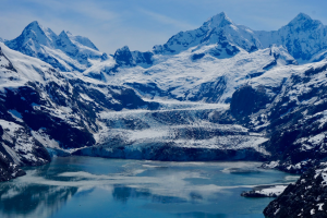
Johns Hopkins Glacier lies beyond Johns Hopkins Fjord. Credits: University of Alaska Fairbanks/Christopher Larsen

According to Christopher Larsen, project manager of Operation IceBridge (OIB) Alaska, these glaciers are losing on the order of 75 billion tons of ice each year, which contribute to global sea level rise. Learning more about these mysterious, ancient ice formations could give scientists a better understanding about the impacts of global climate change in the Arctic.

Thousands of miles above the surface of these glaciers, satellites collect data on how these gargantuan slabs of ice are changing. Ice, Cloud and land Elevation Satellite-2 (ICESat-2) was launched in 2018, 11 years after its predecessor was decommissioned. In the decade in between, OIB bridged the gap, collecting data and exploring Alaskan glaciers with a whole new perspective.

Now, two years after ICESat-2 made its way into low-Earth orbit, OIB is finishing its final campaign. Having wrapped up its flight season last week, the team plans to do a final set of flights in August. And Larsen, a research professor at the University of Alaska Fairbanks, will finish up his last of eleven summers managing OIB Alaska.

A view from the wing of the Cessna TU206G while mapping a potential landslide in the Barry Arm and approaching the Barry Glacier. Credits: University of Alaska Fairbanks/John W. Holt

Instead of satellites, his team collects data using instruments aboard two small, single-engine aircraft. They shoot a laser from the bottom of each plane that hits the glacier’s surface and bounces back up. By calculating the amount of time it takes the laser pulses to return to the instruments, Larsen and his team can then estimate the surface elevation of the glacier at specific coordinates.

He said that most science projects at the university only last three years, but IceBridge Alaska has studied glaciers for over a decade.

“I’ve been involved in almost all of the flight campaigns myself,” Larsen said. “It’s really wonderful to have something that’s dedicated to monitoring and observing glaciers over a longer time period.”

Alaskan glaciers are temperate, meaning the ice is at or near melting point, and they melt and refreeze as they adjust to changes in the climate to maintain a balance between ice accumulation and melting. As the Arctic is warming at twice the global average,  ice loss is accelerating, contributing to global sea level rise.

One problem with studying temperate glaciers is measuring depth. Radar doesn’t permeate water well, so determining ice thickness can be a challenge. To resolve this problem, the team must use a different frequency range, which isn’t always 100% effective. Despite this challenge, Larsen and his team have determined that some of the thickest ice in Alaska is on the order of 4,900 feet (1500 meters) and located in the Bagley Ice Valley. If all of that ice were to melt, the whole valley could turn into a lake or fjord.

But predictions of ice melt are hard to make because of the individual nature of glaciers. Like snowflakes, all are unique and respond differently to changes in the environment. “What we’ve found in general is that there’s a lot of variation from glacier to glacier, and it’s hard to pin that to any [common] characteristic of a glacier,” Larsen summarized.

And these glaciers have lost a lot of ice.

Terminus of the Ellsworth Glacier, showing large ice bergs breaking off from the glacier as it retreats. Credits: University of Alaska Fairbanks/Christopher Larsen

Not only are scientific barriers a challenge – physical limitations affect the flight campaign as well. For instance, the weather plays a huge role in the operation’s success. Larsen and his team check the weather constantly and plan their flights a day or two in advance based on wind and storm patterns. Weather is the true determinant of where and when they can fly. While satellites collect data at set intervals, planes that rely on clear and calm skies don’t always have this luxury.

The greatest challenge, according to Larsen, is collecting measurements of the same glaciers at consistent intervals. “And that’s driven mainly because you’re operating a light aircraft in large mountains with big weather systems,” he explained.

Nevertheless, the IceBridge Alaska campaign has been able to successfully collect data by running a relatively small campaign with a flexible team. Their pilots sometimes have to change survey paths mid-flight due to the weather, and research teams work proactively to prioritize safety and efficiency. Adding a new plane this summer has boosted productivity exponentially.

Besides their successful data collection on Alaskan glaciers, the IceBridge team has combined scientific processes with personal observations, some of which have been peculiar, to say the least.

Case in point: While flying over Yakutat Glacier, on the Gulf of Alaska’s coast, Larsen was surprised to see that the glacier was almost entirely concealed by a dark mass. When the plane flew closer, he realized that the ice was actually covered by many fuzzy moss balls, fondly nicknamed “glacier mice” by researchers. These tumbleweeds of Alaskan glaciers are still a mystery to scientists who track their movements. Larsen has seen Yakutat Glacier break apart into large icebergs and retreat significantly over the past few years. Most of the moss balls have ended up in Harlequin Lake.

Fuzzy moss balls, nicknamed glacier mice, gather in piles on Yakutat Glacier. Scientists have observed these moss balls change position over time, but the nature behind this movement is still largely a mystery. Credits: University of Alaska Fairbanks/Christopher Larsen