What to Expect from the Arctic

Guest science writer KarenRomano Young reports from the ICESCAPEmission:
The U.S. Coast Guard Cutter Healy, our chunky red-and-white icebreaker, sits at the gates of the Arctic Ocean. In the wee hours this morning, the sun set and quickly rose again, and a rainbow stretched up into low clouds. The ICESCAPE mission had reached station 5 of a seven-stop transect of the Bering Strait, between Fairway Rock — resembling Kong Island, but with pointy ears — and Little Diomede (U.S.) — something like the “Cliffs of Insanity” in The Princess Bride. Close by is Big Diomede (Russia), topped with fog.

Movie references aside, this is a dramatic spot in which to find yourself when you wake up in the morning — or in the evening, as is the case for the half of the science crew working the night shift to process the samples.

It seems that no matter how many times a scientist has been to sea, it doesn’t get old. Greg Mitchell (below right), a specialist in ocean optics from the Scripps Institution of Oceanography, reckons he has spent about four years of his life aboard ships. His first trip to the Arctic was in 1987, his first year at Scripps. Mitchell’s research has taken him all over the world — to Antarctica and back again many times — but he hasn’t been inside the Arctic Circle since 1989. He expects change. Greg Mitchell

Observing the system…..and how it interacts with the edge of the sea ice…..and what’s going on with the ice melt…..and how it affects the ocean…..those principles won’t be any different than they were 20 years ago. “What we’re clearly seeing is that the sea ice is reducing more and more all the time,” said Mitchell. “This means less sunshine reflecting off the ice back into space, and more getting into the ocean.”

He expects the increase in sun-light on the sea to do three things:

  • “The light that’s not reflected will heat the ocean, accelerating the warming and accelerating the melting of the sea ice.”
  • “As the ocean warms it becomes more stratified. If you dive in a lake in the summertime, it’s warmer at the surface. But as you dive down, you feel the cold. That’s because the warm water is lighter than the cold water, and it stays at the surface. That’s thermal stratification. As you warm the ocean, it’ll stratify more and that will create a warm layer with a lot of light for algae to bloom (as long as they have nutrients).”
  • “More light in the ocean should cause more total photosynthesis in the Arctic, so we’ll lose habitat for polar bears but we’ll gain habitat for plankton.”

Like the rest of us, Mitchell is concerned about that. “I’m not saying it’s a good trade off. I think we should leave things alone. But the system’s changing, and as it changes we don’t know what the consequences of those changes will be. It’s hard to say what we could do. What we really need to do is to find a way for humans to have smaller footprint on earth. So we need to understand the processes better and then we need to model it.”

That’s why he’s here.

Mitchell, along with his group from Scripps, is involved in ground-truthing the optical properties of the Arctic Ocean (photos at the top and bottom of this post). That is, he’s helping to ensure that what they see at the surface squares up with the methods NASA satellites use to assess ocean color, an indicator of the level of chlorophyll and, by proxy, phytoplankton. NASA’s satellites measure the color of the ocean by flying over the earth and picking up blue, blue green, and green. If there’s not a lot of algae, the ocean is blue. If there is a lot of algae, the ocean is green.

But color is just one way of looking at phytoplankton levels. In order to truly assess the situation — for example how much carbon dioxide the phytoplankton are taking in – scientists need to assess the processes at work in the sea. “The optics don’t tell us this, so we have to take water samples, process the water, and then relate that to the optics we measure from the ship,” Mitchell said.

The global mapping you can see on the NASA site uses mathematical equations developed from the shipboard work. Satellite validation and calibration is based on the findings of scientists who go to sea and study the water to see what’s living there. Mitchell’s research group claims responsibility for about 20 percent of the global observations used by NASA for their models to convert satellite-measured optical measurements to chlorophyll estimates.

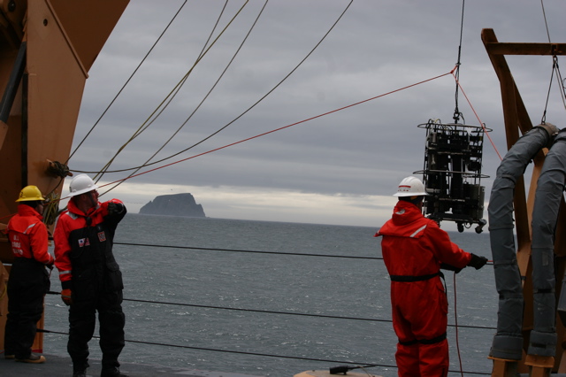
lowering gear from the Healy

The data contributes to models that allow prediction of primary production — the growth and health of organisms — under various conditions. Mitchell’s instruments include a small optical profiler — a fish-shaped instrument lowered from the Healy’s bow — and an optical package of instruments that measure water properties when it is lowered from the powerful A-frame at the stern.

“As ecologists, we don’t want to just know what color the ocean is,” he said. “We want to know how much plankton there is.” He walks to the edge of the ship and looks over the rail. “Now what we’re seeing out here is green water. There’s a lot of chlorophyll.” That means a strong pulse of phytoplankton, busy photosynthesizing the extra sunlight.

All photos shot by and courtesy of Karen Romano Young

Puzzling Over the Pieces

Guest contributor Karen Romano Young (photo at right) blogs from NASA’s ICESCAPE expedition…

There’s a sign on the door of the room I share with Sharmila Pal and Emily Peacock. It’s a green square of plastic engraved with a picture of a polar bear and the words “SCIENCE – LATE SLEEPER.” So many of the scientists aboard Coast Guard Cutter Healy for the ICESCAPE mission are awake through the night that the ship’s engraver, Chief Warrant Officer 3 Sean Lyons, has turned out a special  edition of late sleeper signs, complete with a rocket ship for NASA. Almost every door boasts a sleeper sign of one kind or another.

The reason? Aboard ICESCAPE, the science goes on 24 hours a day. We’re on a path to the far north, steaming from station to station through the night. Sometimes we’re in ice, sometimes we’re in open ocean, sometimes there’s a mix. Sometimes, there are walruses and seals. Each group of scientists has divided their schedule into shifts, so while some are catching their zzz’s behind those “late sleeper” signs, others are awake and overseeing operations, making measurements, and processing samples.

NASA’s Stanford Hooker takes the small boat out to measure light and take water samples, away from the interference of the ship. Karen Frey’s group from Clark University works on ice stations and takes Van Veen grabs in the open sea. (It’s like a giant pooper-scooper that scoops sediment from the ocean floor).

Bob Pickart of the Woods Hole Oceanographic Institution works to assess currents and other elements of physical oceanography, such as eddies and upwelling, as we pass through the ocean. James Swift, from Scripps Institution of Oceanography, oversees the CTD, a rosette of siphons and bottles triggered to sample water at various depths. (CTD stands for conductivity, temperature, and depth.) Greg Mitchell, Rick Reynolds, and their groups from Scripps measure the ocean’s optical properties with a small profiler dropped from the bow and with the Inherent Optical Properties (IOP) package of instruments deployed from the stern.


Sketch by Karen Romano Young

“We’re all working on different pieces of the same puzzle,” Reynolds says. “It’s impossible for one group to measure all we need to know. [Chief Scientist] Kevin Arrigo’s group is looking at core pigments, the plant pigments in the water column. Others are looking at chemical analyses of the nutrients in the water. It’s a big team effort. The ice people are working in a completely different environment, but there are algae in both places.”

The $250,000 IOP suite of instruments assesses the health of the ocean by analyzing the absorption and scattering of light by particles suspended in the water, including chlorophyll-rich algae; the quantity and quality of algae (the health and growth rate); and the presence of minerals and sediment. Each instrument on the IOP contributes to a picture of the makeup of the particles by assessing changes in light transmission.

“We start at the top,” says Reynolds (shown at left). “We look at what the NASAsatellite sees — the sea color — and parse out the differentcharacteristics of the water — how much algae, and what else is there,such as minerals from rivers, re-suspended sediment (mud stirred intothe water) and melting ice.” The resulting data will help thescientists develop new algorithms — equations for solving problems –to support the satellites.

NASA ice- and ocean-observing satellites, now working for more than ten years, are beginning to allow us to examine changes in the climate. One purpose of ICESCAPE is to look at the ocean with greater detail than the satellites offer, in order to improve and refine the interpretation of the satellite data. 

“We’re here because NASA wants to know what the satellites are seeing right here at the stations,” says Reynolds, “where nobody else may sample for decades, because the ocean is so vast.”

All imagery, including the IOP sketch, courtesy of Karen Romano Young 

Fun with Aureoles and Aerosols

 
      Credit: Earth Science Picture of the Day/Rob Rathkowski


Earth Science Picture of the Day (EPOD)
recently ran a series of photos that illustrates nicely the impact that small airborne particles called aerosols can have on light.

As EPOD notes, the size of an aureole — the halo-like circle that appears around the sun when viewed through a haze or mist — depends on the amount of aerosol in the air. More aerosols mean more light is scattered, which produces larger aureole). Since most aerosols are concentrated near Earth’s surface, the aureole at sea level appears much larger than it would high on a mountain peak. You can try this experiment yourself to get a sense of the aerosol load in the air you’re breathing.

Aerosols are a major preoccupation for climate scientists as the particles—including dust, ash, sea salt, soot, and industrial pollutants—can scatter light and affect Earth’s energy balance. Infusions of ash and sulfate from volcanic eruptions, for example, are capable of cooling global temperatures by 0.3 degrees Celsius. Likewise, sulfate aerosols from factories and power plants can mask global warming somewhat and are often bandied around as possible components of geoengineering schemes.

Want to learn more about how aerosols scatter light? EPOD has another post on the topic that compares aureoles at sunsets in the Netherlands before (below left) and after (below right) the arrival of a massive volcanic ash cloud from the eruption of Eyjafjallajökull. Also, for optics aficionados, a site called Atmospheric Optics will walk you through a number of interesting examples of aerosols and atmospheric water and ice scattering light.


        Credit: Earth Science Picture of the Day/Kosmas Gazeas
— Adam Voiland, NASA’s Earth Science News Team