Every planet changes. To document these changes and what we know about them across millennia is the goal of some of our flagship missions at Mars, Jupiter and elsewhere through our solar system.
Our own planet is another story. Because we live here, those changes in our landscape take on a more urgent, vital concern. Documenting our home from many angles and wavelengths are a fleet of Earth observation satellites operated by many nations as well as commercial entities. NASA and its agency partners help manage an incredible array of these assets.
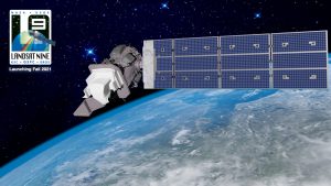
Now we are targeting Landsat 9 for launch Sept. 27. It carries on a grand tradition that for nearly 50 years has generated a data record of our planet and its changing land, and the imprints that natural disasters and climate change have made visible from space. The world has never seen anything like the Landsat missions before. The continuity of measurements they have provided is an invaluable global asset free to all that helps us understand the very place we live – not just our continent or our nation, but our region and our city and local environment.
Begun in the early days of the 1970s during a time of heightened awareness of threats to our environment, Landsat has continued to remain relevant today. These missions help us see where the place we live – the land we depend on for survival on this ocean world – continues to evolve. We can see the decades of recovery from the Mt. St. Helens eruption, or the effects of fires that raged across the Amazon recently.
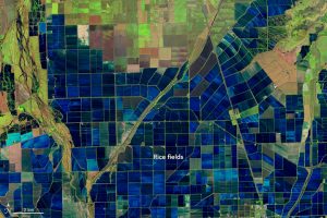
Thanks to Landsat we can see how urbanization has changed over two generations. How crops have shifted and where they are grown and how well they’re doing. And how much of our precious water there is to grow them. Wildfires. Hurricanes. Extreme weather of all sorts. We can help see what’s happened and how the environment recovers.

The Landsat missions have had perhaps more impact on peoples’ daily lives than any other Earth observation mission. They’ve had huge economic impact and are the crown jewels in our Earth fleet.
Together with our Landsat partners at the U.S. Geological Survey, we have surveyed our planet rigorously and continuously and stored and shared that information. The earliest geological surveyors plodded across massive landscapes barely scraped by human eyes and now we image the entire Earth in around two days by teaming up with the Landsat 8 satellite we’ll be working with on orbit, and a Sentinel satellite from ESA. Scientists who were not born when Landsat first began to study our planet now look forward to carrying its tradition forward.
![]()
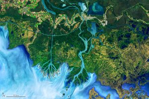
Just imagine — at every point in our planet’s life over the past 50 years, Landsat was working hard to help us see our world. Through wars and famines and droughts and storms and manmade events. The data Landsat provides helps us understand how to live better together on the ground. End users of its data are people like farmers and disaster preparedness staff, urban planners, crop managers and food sustainability professionals. And the artists and creative among us who see how an image of a river delta can also be a tree, and about the beauty in the processes constantly shaping our changing planet. #LandsatArt
So join us Sept. 27 at 11:12a.m. PT for the launch of Landsat 9 on nasa.gov/live. Or join our Facebook event page for behind the scenes tours. And please join the global #Landsat conversation about how we study our planet and how that matters to us all.