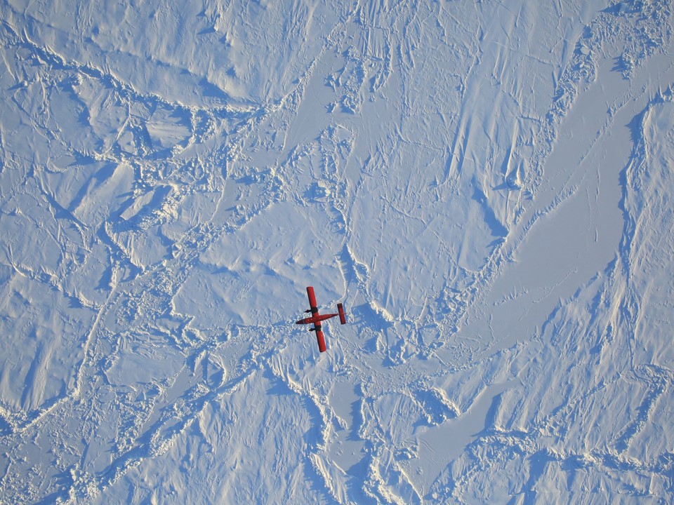
by Maria-Jose Viñas / THULE, GREENLAND /
Do you remember that dreaded math problem in high school, the one where two trains left different stations traveling at different speeds toward each other and you had to calculate when and where they would meet? Now try solving a variation of this problem where the two trains are substituted with three very different aircraft—two leaving from the Canadian Arctic, one from northwestern Greenland—plus a satellite flying overhead. This was the logistical puzzle that Operation IceBridge, NASA’s airborne survey of changing polar ice, had to crack on Friday, March 24, during its ninth Arctic campaign.
The original plan had involved four planes: IceBridge’s P-3, the G-III from NASA’s Oceans Melting Greenland (OMG) campaign and two aircraft from the European Space Agency (ESA)—a Twin Otter and a Basler dubbed Polar 5, both carrying laser scanners and radars, among other instruments. The goal was for all of the planes to fly the same path over sea ice, right beneath one of ESA’s CryoSat-2 satellite tracks, while simultaneously collecting measurements so that scientists could later compare the data gathered by the different instruments on the three planes and the spacecraft’s radar altimeter.

“The primary reason for the whole exercise was to cross-calibrate the CryoSat-2 radar with all of our radars and lasers,” said John Sonntag, IceBridge mission scientist. “This will allow us all to better understand the performance of our instruments and how well we perform our surveys”.
Early in the morning of Thursday, March 24, IceBridge’s P-3 and OMG’s G-III took off from Thule Air Base in northwest Greenland and headed to the Lincoln Sea, north of Canada. They were planning to rendezvous there with the two ESA planes, which were based in Alert Station, a Canadian base in Ellesmere Island, in the Canadian Arctic. Since the Twin Otter and Polar 5 were located closer to the target site, the Europeans would depart Alert four hours after the NASA planes had left Thule. But before they could take off, an unexpected fog bank rolled over Alert, shutting the airport down.
Still, IceBridge and OMG proceeded with their flight, sampling the thick multi-year ice near the Ellesmere coast and the gradient to thinner ice closer to the North Pole with their instruments: OMG’s radar mapper and IceBridge’s suite of instruments, encompassing a scanning laser altimeter that measures ice surface elevation, three types of radar systems to study ice layers and the bedrock underneath the ice sheet, a high-resolution camera to create color maps of polar ice, and infrared cameras to measure surface temperatures of sea and land ice.
The following day, the IceBridge team decided to give it another go but OMG had already exhausted its allotted flight hours and had to stay on the ground. To increase their confidence that their European collaborators would be able to fly that day, the P-3 took off one and a half hours later than it normally would have. This time, it was a success: the three aircraft flew over the CryoSat-2 track line (one a few dozen miles east of the one IceBridge and OMG had flown the day before) within 42 minutes of each other. The satellite overflew the same line just two minutes after IceBridge had completed it.

“Ideally, all three aircraft and the satellite would be over the same point at exactly the same time, but that’s almost impossible to do with three airplanes operating at different speeds and altitudes,” Sonntag said. “Still, we had some flexibility because the sea ice moves slowly—as long as we all flew over it within two hours, we could be sure we were all measuring the same ice.”
It will take scientists from the different teams about six months to process all the measurements before they’re able to compare them, but NASA and ESA are already calling the collaboration a success.
“This collaboration took a lot of careful coordination,” Sonntag said. “It demonstrates the commitment of ESA and NASA to work cooperatively to better understand the cryosphere.”
