By Zachary K. Erickson, NASA Goddard Space Flight Center / GREENBELT, MARYLAND /
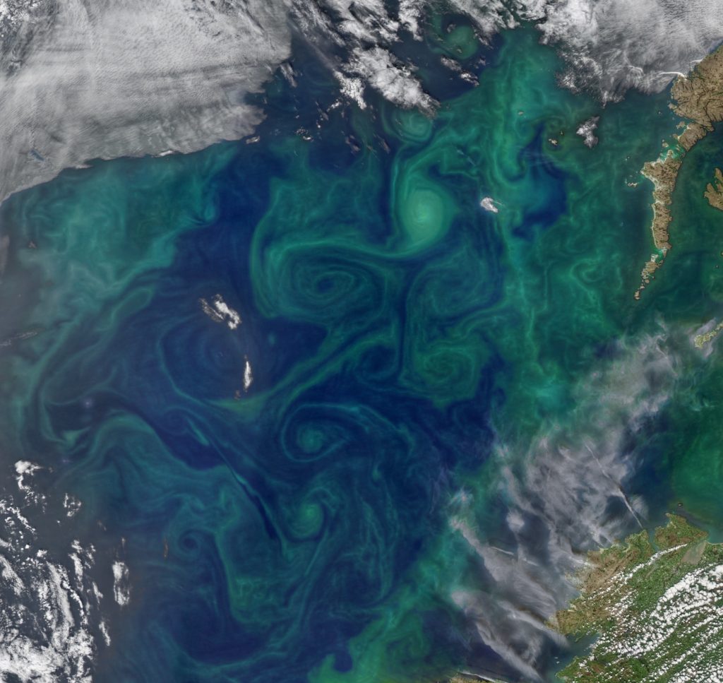
The ocean is full of eddies – swirling water masses that are the ocean equivalent of hurricanes. In comparison with their atmospheric counterparts, eddies are smaller, longer-lived, and far more numerous: at any given moment, well over 1,000 eddies exist throughout the global ocean, with diameters typically between 30 and 200 miles (about 50 to 300 kilometers). On average they last for one or two months, but about 20% last for four months and a small fraction can last for over a year.

We decided to locate the North Atlantic EXPORTS field deployment within an eddy because eddies tend to trap water masses in their core. This means that if we put multiple instruments in the eddy core, we can be pretty sure that they will stay close together. In a campaign involving dozens of individual instrument platforms, it is much easier to organize and understand the measurements when they are all near each other! Additionally, if the eddy core primarily contains trapped water, we can interpret changes in the water properties – such as a decrease in nutrient levels or an increase in biomass – as resulting from biological processes happening within the eddy, rather than from other external factors.
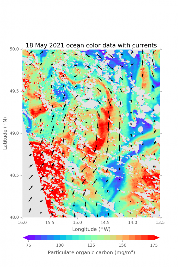
The main way we look for eddies is by using data from a constellation of satellites continuously orbiting the earth. These satellites use radar to very precisely measure the height of the ocean surface. On a global scale, these measurements help scientists track sea level rise. Locally, we use these measurements to track eddies, which either look like hills or valleys in sea surface height depending on if they are rotating in a clockwise or counterclockwise direction (in the northern hemisphere; this is flipped in the southern hemisphere). A sea surface “valley” is directly analogous to the low pressure associated with hurricanes, which rotate in a counterclockwise direction (in the northern hemisphere).

Once we find an eddy, we try to predict how long it will last. For the EXPORTS field deployment, it was important to pick an eddy that was going to last for at least a month, which is the length of the main part of the deployment. We look at data from years past to identify characteristics of eddies that are long-lived, such as their size (bigger is better) and how symmetrical they are (circular eddies are better than oblong shapes). We also use numerical simulations to drop “particles” in a given eddy and track whether or not they appear to be trapped within the center or if they escape from the eddy. From these we generate a prediction for each eddy of how long, and how well, it will trap water masses within its core. For this experiment, we want a long-lived eddy that effectively traps water!

After we have a small number of candidates, we need measurements from instruments in the water. It is very important to know what the eddy looks like beneath the surface, below where we have data from satellites. The EXPORTS project is centered around measuring carbon “export”, or how carbon locked up in biomass is transported from the ocean surface to the deep ocean interior. So, it is important that our chosen eddy effectively trap water masses down to about a thousand feet (about several hundred meters).
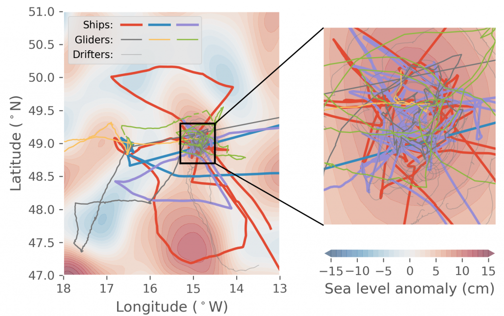
Initially, we get these measurements from ocean gliders, autonomous platforms that adjust their density to move up and down within the upper 0.6 miles (about 1 kilometer) of the water column, taking measurements of temperature, salt concentration (salinity), oxygen levels, and biomass along the way. Three gliders were deployed in early April, and these measurements were supplemented by data from three research ships in May, as well as the aforementioned dozens of platforms deployed within and around the eddy.
Throughout the course of the field deployment, a group of scientists on “shore duty” (including numerous institutions such as NASA Goddard Space Flight Center, University of Washington, University of Rhode Island, CalTech, University of California Santa Barbara, Woods Hole Oceanographic Institution, and the National Oceanography Centre in the United Kingdom) use all of these data to track daily changes in how our chosen eddy is evolving over time, making sure that we center measurements on the core mass of trapped water in the center. There’s still a chance that the eddy will break up, but two-thirds of the way through the mission, all evidence points to our having made a good choice in picking an eddy that will stay present at least throughout the course of this field deployment, and perhaps for many weeks or months afterwards!
