Sep. 17, 2018 – NASA Sees Post-Tropical Cyclone Helene Affecting Ireland, United Kingdom
Post-tropical cyclone Helene developed off the west coast of Africa and moved north then northeast where it is now raining on parts of Ireland and the United Kingdom. Clouds and rainfall connected to Helene are already affecting those countries.
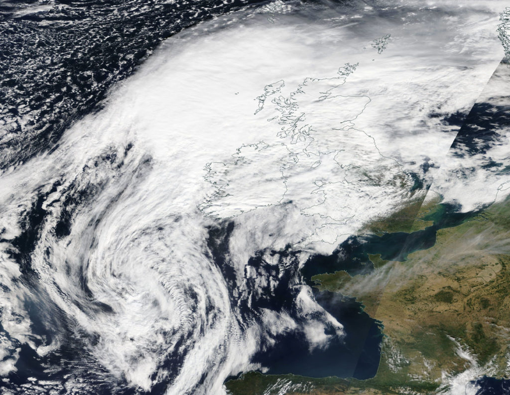
Early on Sept. 17, the Moderate Resolution Imaging Spectroradiometer or MODIS instrument aboard Aqua captured a visible image of Post Tropical Cyclone Helene southwest of Ireland and the United Kingdom (U.K.). The MODIS image showed a large system with a wide band of clouds and showers extending to the northeast over Ireland and the U.K.
There is a Yellow Alert for the U.K. regions of: Central, Tayside & Fife, East Midlands, East of England, Grampian, Highlands & Eilean Siar, North East England, North West England, Northern Ireland, Orkney & Shetland, SW Scotland, Lothian Borders, South West England, Strathclyde, Wales, West Midlands, Yorkshire & Humber.
The U.K. Meteorological Service noted that the Yellow Alert means “a spell of very windy weather is expected. Gusts of 50-60 mph are possible inland between [1 a.m. and 5 p.m. local time on Wed., Sept. 19].”
For updated forecasts, visit: https://www.metoffice.gov.uk/
By Rob Gutro
NASA’s Goddard Space Flight Center
Sep. 14, 2018 – NASA-NOAA Satellite Find Wind Shear Affecting Helene, Azores Warnings Up
Tropical Storm Helene may be battling wind shear but it’s caused a Tropical Storm Warning for all of the Azores Islands on Sept. 15. NASA-NOAA’s Suomi NPP satellite passed over the eastern Atlantic Ocean and analyzed the storm.
Southwesterly shear continues to affect now Tropical Storm Helene as it nears the Azores. In general, wind shear is a measure of how the speed and direction of winds change with altitude. Winds at different levels of the atmosphere pushed against the cylindrical circulation center and skewed it, weakening the rotation.
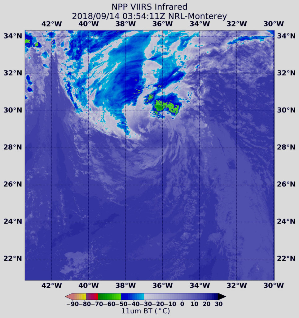
On Sept. 14 at 1:36 a.m. EDT (0536 UTC) the Visible Infrared Imaging Radiometer Suite (VIIRS) instrument aboard NASA-NOAA’s Suomi NPP satellite captured an infrared image of Tropical Storm Helene. VIIRS showed wind shear was pushing all of the strongest storms northeast of center. In that quadrant of the storm, the coldest cloud top temperatures of strongest thunderstorms were as cold as minus 50 degrees Fahrenheit/minus 45.5 degrees Celsius.
The National Hurricane Center or NHC said “at 11 a.m. EDT (1500 UTC) the center of Tropical Storm Helene was located near latitude 32.9 degrees north and longitude 36.3 degrees west. Helene is moving toward the north near 23 mph (37 kph). A turn toward the north-northeast is forecast Saturday followed by a turn toward the northeast by Sunday night.
Satellite data indicate that maximum sustained winds have increased to near 70 mph (110 kph) with higher gusts. Little change in strength is forecast during the next 24 hours. Afterward, gradual weakening is expected over the weekend as Helene makes the transition to a post-tropical extratropical cyclone.
On the forecast track, Helene will pass near or over the Azores late Saturday, Sept. 15 or Sunday, Sept. 16.
Helene is expected to produce total rainfall amounts of 2 to 4 inches across the Azores, with isolated amounts up to 8 inches across the western Azores. This rainfall may cause life-threatening flash flooding. Ocean swells generated by Helene are affecting portions of the Azores. These swells are likely to cause life-threatening surf and rip current conditions.
Interests in the Ireland and United Kingdom should consult products from their local meteorological service for information about potential impacts from Helene in those locations.
Local forecasts and warnings for the U.K. can be found on the website of the UK Met Office at https://www.metoffice.gov.uk/.
Local forecasts and warnings for Ireland can be found on the website of Met Eireann at https://www.met.ie/.
For updated forecasts, visit: www.nhc.noaa.gov
By Rob Gutro (with information from NHC)
NASA’s Goddard Space Flight Center
Sep. 13, 2018 – NASA Sees Hurricane Helene Decoupled By Wind Shear
NASA’s Aqua satellite provided an infrared look at Helene as it continued tracking toward the Azores Islands in the Eastern Atlantic Ocean. Satellite imagery shows that Helene is decoupled from wind shear.
The National Hurricane Center or NHC said “Helene’s surface circulation has become fully exposed this morning with the center decoupled about 110 miles south of edge of the remaining deep convection.” That means that the circulation or center of the storm is off-center, and the bulk of the storm has been pushed away from the rotating center. That decoupling happened because Helene is dealing with southwesterly (coming from the southwest) vertical wind shear. NHC noted that the wind shear is expected to increase later on Sept. 13.
What is Wind Shear?
In general, wind shear is a measure of how the speed and direction of winds change with altitude. Wind shear can tear a tropical cyclone apart or weaken it.
NASA’s Infrared View of Helene
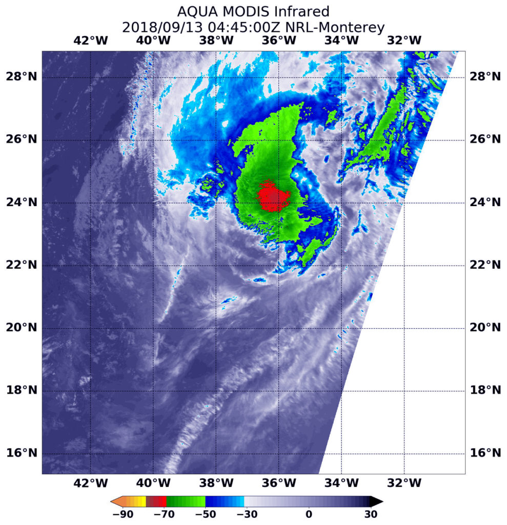
NASA’s Aqua satellite passed over Hurricane Helene on Sept. 13 at 12:45 a.m. EDT (0445 UTC) and the Moderate Resolution Imaging Spectroradiometer or MODIS instrument aboard analyzed cloud top temperatures in infrared light. Coldest cloud top temperatures were being pushed northeast of center and were as cold as or colder than minus 70 degrees Fahrenheit (minus 56.6 Celsius). Cloud top temperatures that cold indicate strong storms that have the capability to create heavy rain.
Helene’s Status on Sept. 13, 2018
At 5 a.m. EDT (0900 UTC), the center of Hurricane Helene was located near latitude 23.5 degrees north and longitude 37.3 degrees west. Helene is currently about 1,170 miles (1,885 km) miles southwest of the Azores. Helene is moving toward the north near 14 mph (22 kph). A turn toward the north-northeast with an increase in forward speed is expected tonight followed by a turn toward the northeast over the weekend of Sept 15 and 16.
Maximum sustained winds have decreased to near 75 mph (120 kph) with higher gusts. Continued weakening is forecast over the next couple of days, and Helene is expected to become a tropical storm by tonight.
Heads Up to the Azores
On Sept. 13, Helene is weakening while moving northward over the eastern Atlantic and interests in the Azores should monitor the progress of the storm.
For updated forecasts, visit: www.nhc.noaa.gov
By Rob Gutro
NASA’s Goddard Space Flight Center
Sep. 12, 2018 – NASA Looks at Hurricane Helene’s Water Vapor Concentration
When NASA’s Terra satellite passed over the Eastern Atlantic Ocean on Sept. 12 it analyzed water vapor within Hurricane Helene.
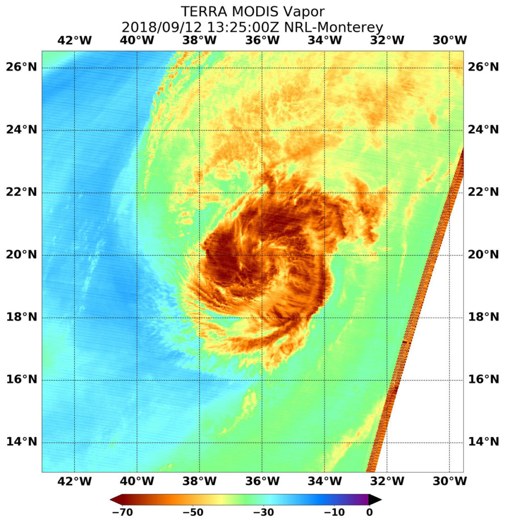
NASA’s Terra satellite passed Hurricane Helene on Sept. 12 at 9:25 a.m. EDT (1325 UTC) and the Moderate Resolution Imaging Spectroradiometer or MODIS instrument gathered water vapor content and temperature information. The MODIS image showed highest concentrations of water vapor and coldest cloud top temperatures were around the center and a band of thunderstorms spiraling in from the east. The MODIS image also showed that the eye has become less distinct, although the storm remains well organized and symmetric.
MODIS saw coldest cloud top temperatures were as cold as minus 70 degrees Fahrenheit (minus 56.6 degrees Celsius) in those areas. Storms with cloud top temperatures that cold have the capability to produce heavy rainfall.
Water vapor analysis of tropical cyclones tells forecasters how much potential a storm has to develop. Water vapor releases latent heat as it condenses into liquid. That liquid becomes clouds and thunderstorms that make up a tropical cyclone. Temperature is important when trying to understand how strong storms can be. The higher the cloud tops, the colder and the stronger they are.
At 11 a.m. EDT (1500 UTC), the eye of Hurricane Helene was located near latitude 20.3 degrees north and longitude 36.5 degrees west. Helen is 1,350 miles (2,170 km) south-southwest of the Azores Islands.
Helene is moving toward the north-northwest near 14 mph (22 kph). A turn toward the north and northeast with an increase in forward speed is expected during the next few days. Maximum sustained winds remain near 90 mph (150 kph) with higher gusts. Gradual weakening is forecast over the next couple of days, and Helene is expected to become a tropical storm on Thursday, Sept. 13.
NHC said that Helene forecast to weaken over the eastern Atlantic and that interests in the Azores Islands should monitor the progress of Helene.
By Rob Gutro
NASA’s Goddard Space Flight Center
Sep. 11, 2018 – NASA-NOAA’s Suomi NPP Satellite Stares Helene in the Eye
NASA-NOAA’s Suomi NPP satellite passed over the eye of Hurricane Helene in the eastern Atlantic.
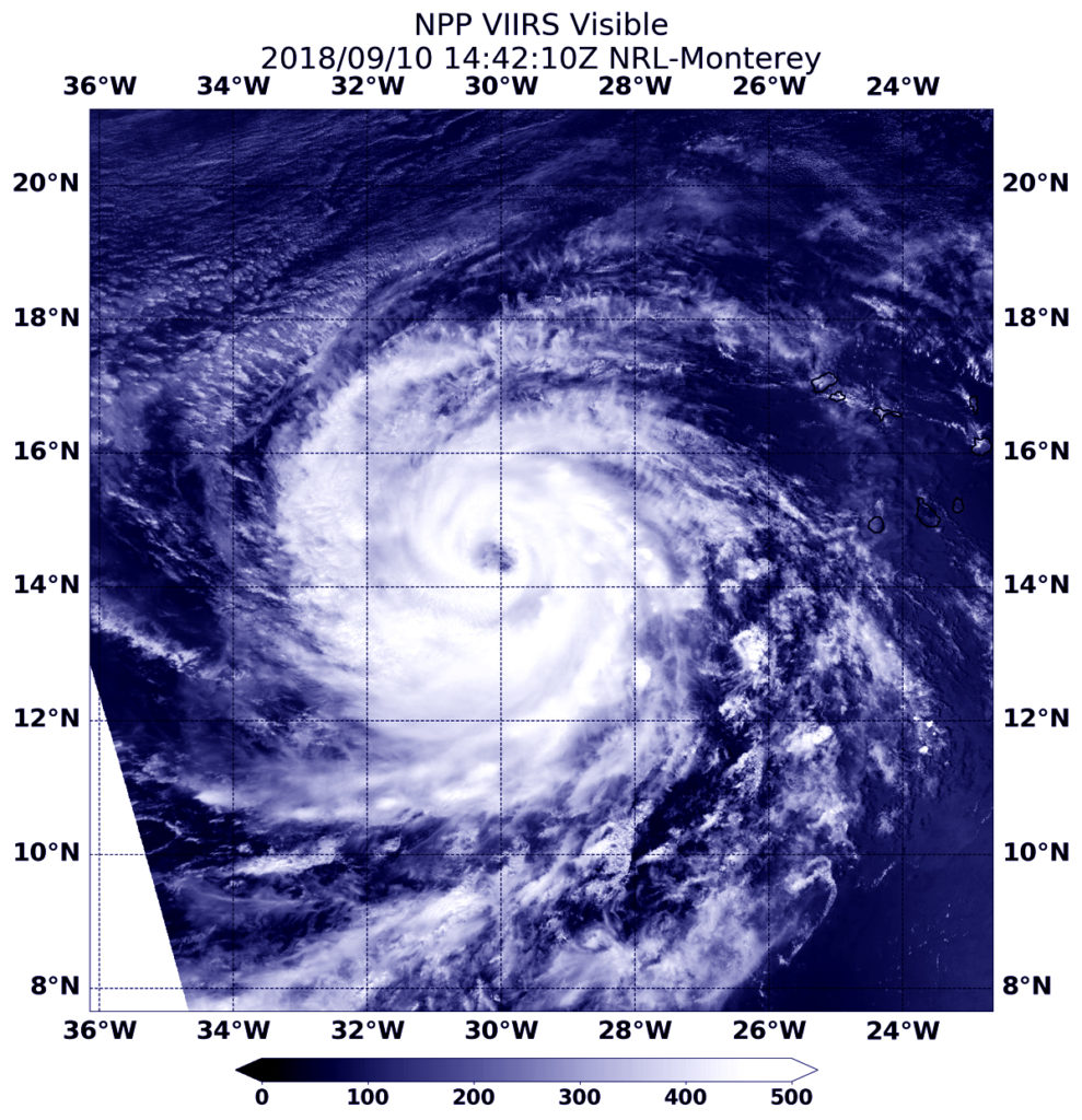
On Sept. 10 at 10:42 a.m. EDT (1442 UTC) the Visible Infrared Imaging Radiometer Suite (VIIRS) instrument aboard NASA-NOAA’s Suomi NPP satellite captured visible image of Hurricane Helene. VIIRS imagery showed the eye was about 20 nautical miles wide.
The next day, Sept. 11, NOAA’s National Hurricane Center noted another satellite image of Helene showed a well-developed closed eyewall and strong band of thunderstorms with cold cloud tops of minus 104 degrees Fahrenheit/minus 76 degrees Celsius (indicating very strong storms) wrapping around the south through east quadrants of the cyclone.
At 5 a.m. EDT (0900 UTC), on Sept. 11 the center of Hurricane Helene was located near latitude 16.0 degrees north and longitude 33.6 degrees west. That’s about 620 miles (995 km) west of the southernmost Cabo Verde Islands and about 1,570 miles (2,530 km) south-southwest of the Azores Islands.
Maximum sustained winds are near 110 mph (175 kph) with higher gusts. Some strengthening is possible during the next 12 hours, but a gradual weakening trend is expected after that time.
Helene is moving toward the west-northwest near 14 mph (22 kph), and this motion is expected to continue with a decrease in forward speed through tonight. A turn toward the northwest and then north-northwest is forecast on Wednesday, Sept. 12 and Thursday, Sept. 13.
For updated forecasts, visit: www.nhc.noaa.gov
By Rob Gutro
NASA’ Goddard Space Flight Center
Sep. 10, 2018 – NASA Sees an Organized Hurricane Helene near Africa
Visible image from NASA’s Aqua satellite showed that newly developed Hurricane Helene had strengthened and organized quickly.

Tropical Depression 8 formed on Sept. 7 at 11 a.m. EDT and strengthened in a tropical storm on by 11 p.m. EDT that day. When it became a tropical storm it was re-named Helene.
On Sept. 10 from the Moderate Resolution Imaging Spectroradiometer or MODIS instrument aboard NASA’s Aqua satellite showed an organized storm with a thick band of powerful thunderstorms circling the eye.
The National Hurricane Center noted at 11 a.m. EDT on Sept. 10, “Helene’s cloud pattern has become much better organized during the past few hours, with a clear 20 nautical miles wide eye seen in Meteosat infrared imagery.
At 11 a.m. EDT (1500 UTC) on Sept. 10 the National Hurricane Center of NHC noted the eye of Hurricane Helene was located near latitude 14.6 degrees north and longitude 30.0 degrees west. It was located about 375 miles (600 km) west of the southernmost Cabo Verde Islands so there are no watches or warnings in effect.
Helene is moving toward the west-northwest near 16 mph (26 kph). A west-northwestward motion with a decrease in forward speed is expected through late Tuesday, followed by a turn toward the northwest and then toward the north-northwest on Wednesday and Thursday. Maximum sustained winds have increased to near 105 mph (165 kph) with higher gusts.
Some additional strengthening is expected today, and Helene is forecast to become a major hurricane by tonight. Steady weakening is forecast to begin by late Tuesday.
For updates on Helene, visit: www.nhc.noaa.gov