Sep. 18, 2018 – NASA Infrared Imagery Reveals Wind Shearing Tropical Depression Joyce
NASA’s Aqua satellite provided an infrared look at Tropical Depression Joyce and found wind shear was pushing the bulk of clouds and showers to the east of the center.

The National Hurricane Center noted at 5 a.m. EDT on Sept. 18, “The latest convective burst associated with Joyce is weakening due to the effects of 35 to 40 knots of westerly vertical [wind] shear and very dry mid-level air.”
In general, wind shear is a measure of how the speed and direction of winds change with altitude. Wind shear can tear a tropical cyclone apart or weaken it.
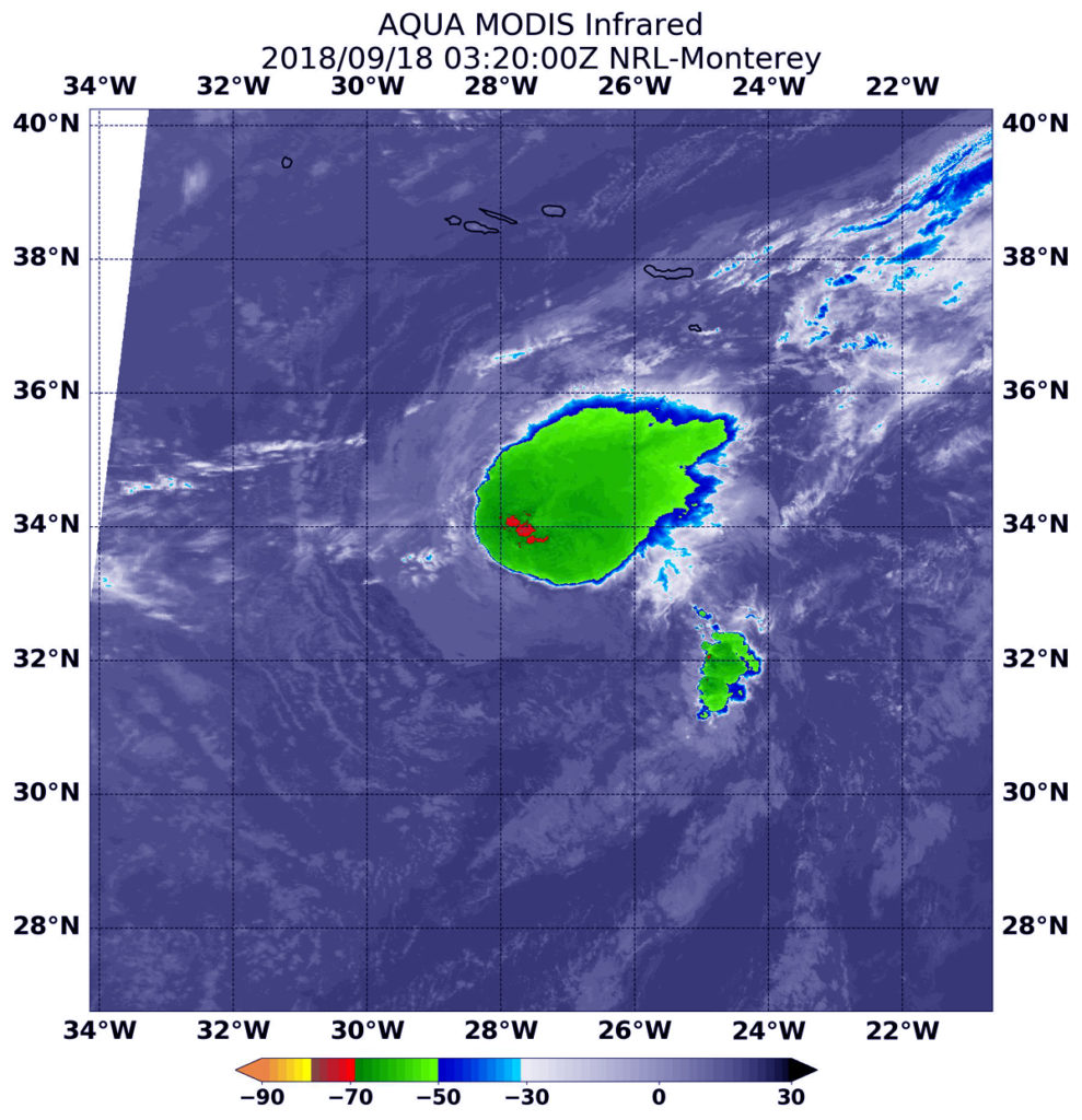
At 11:20 p.m. EDT on Sept. 17 (0320 UTC on Sept. 18), Moderate Resolution Imaging Spectroradiometer or MODIS instrument aboard NASA’s Aqua satellite analyzed Tropical Depression Joyce in infrared light. MODIS found a small area of coldest cloud top temperatures around the center of circulation. Those were as cold as or colder than minus 70 degrees Fahrenheit (minus 56.6 degrees Celsius). The bulk of the storm, however, was being pushed to the northeast from the wind shear.
NASA research has found that cloud top temperatures as cold as or colder than the 70F/56.6C threshold have the capability to generate heavy rainfall.
At 5 a.m. EDT (0900 UTC), the center of Tropical Depression Joyce was located near latitude 32.9 degrees north and longitude 27.6 degrees west. That’s 355 miles (570 km) south of the Azores Islands.
The depression is moving toward the south-southeast near 6 mph (9 kph). A turn toward the south is forecast later today, followed by a motion toward the southwest on Wednesday, Sept. 19 and Thursday, Sept. 20. Maximum sustained winds are near 35 mph (55 km/h) with higher gusts. Gradual weakening is expected during the next couple of days, and Joyce is forecast to become a remnant low later today or tonight.
For updated forecasts on Joyce, visit: www.nhc.noaa.gov
By Rob Gutro
NASA Goddard Space Flight Center
Sep. 17, 2018 – NASA Finds Tropical Depression Joyce Continues to Lose It
Visible and infrared satellite imagery from NASA’s Aqua satellite revealed Tropical Storm Joyce continues to become more disorganized.

On Monday, Sept. 17, 2018, there were no coastal watches or warnings in effect as Joyce was far from land.
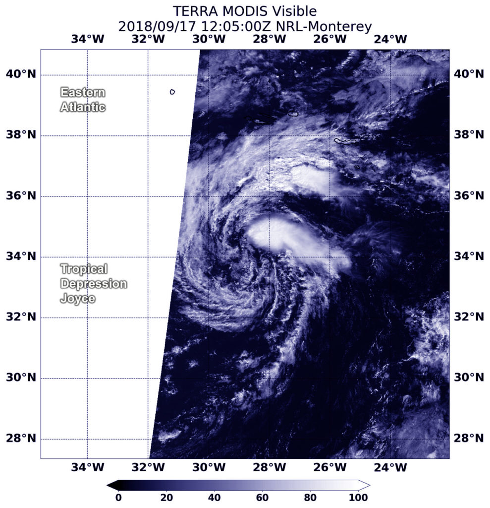
At 8:55 a.m. EDT (1205 UTC) the Moderate Resolution Imaging Spectroradiometer or MODIS instrument aboard Aqua captured a visible image of Joyce. Drier air is moving into the depression causing it to lose organization. The dry air is sapping the storm’s ability to form the thunderstorms that make up a tropical cyclone. Visible satellite imagery shows a few cloud swirls pivoting around a mean center with only a small amount of strongest thunderstorms displaced about 90 miles northeast of the mean center.
At 11 a.m. EDT (1500 UTC) on Sept. 17, the center of Tropical Depression Joyce was located near latitude 34.0 degrees north and longitude 28.4 degrees west. That’s 280 miles (465 km) south-southwest of the Azores Islands.
The National Hurricane Center or NHC said the depression is moving toward the east-southeast near 8 mph (13 kph) and this forward speed is expected to continue while turning toward the southeast today, south on Tuesday, and southwest on Wednesday, Sept. 19. The estimated minimum central pressure is 1008 millibars. Maximum sustained winds are near 35 mph (55 kph) with higher gusts. Some weakening is forecast during the next 48 hours.
Joyce is expected to become a remnant low tonight or Tuesday, Sept. 18.
For updated forecasts from the NHC, visit: www.nhc.noaa.gov
By Rob Gutro
NASA’s Goddard Space Flight Center
Sep. 14, 2018 – Wind Shear Affecting Tropical Storm Joyce in NASA-NOAA Satellite Image
NASA-NOAA’s Suomi NPP satellite passed over the eastern Atlantic Ocean and saw that Tropical Storm Joyce is battling wind shear. Winds are pushing thunderstorm development northeast of the center.

Southwesterly shear continues to affect now Tropical Storm Joyce. In general, wind shear is a measure of how the speed and direction of winds change with altitude. Winds at different levels of the atmosphere pushed against the cylindrical circulation center and skewed it, weakening the rotation.
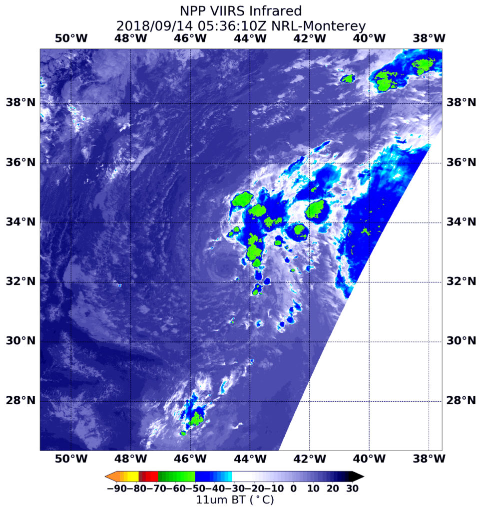
On Sept. 14 at 1:36 a.m. EDT (0536 UTC) the Visible Infrared Imaging Radiometer Suite (VIIRS) instrument aboard NASA-NOAA’s Suomi NPP satellite captured an infrared image of Tropical Storm Joyce. VIIRS showed wind shear was tearing the storm apart. The coldest cloud top temperatures of strongest thunderstorms were as cold as minus 50 degrees Fahrenheit/minus 45.5 degrees Celsius and were northeast of the center.
The National Hurricane Center or NHC said “The system continues to produce bands of convection (developing thunderstorms) over the northeastern portion of the circulation, but the center remains exposed due to shear.”
At 5 a.m. EDT (0900 UTC) the center of Tropical Storm Joyce was located near latitude 32.1 degrees north, longitude 44.9 degrees west. That’s 1,090 miles (1,750 km) west-southwest of the Azores Islands. Joyce is moving toward the south-southwest near 8 mph (13 kph). Joyce is forecast to slow down and turn eastward by tonight, and then accelerate northeastward over the weekend.
Maximum sustained winds are near 40 mph (65 kph) with higher gusts. Little change in strength is forecast during the next couple of days.
Joyce is also close to Helene. In fact, Joyce is being steered in that direction around the larger circulation of Helene, located to its east-southeast. Once Helene passes east-northeast of Joyce later today, Joyce should turn eastward, then begin to accelerate northeastward over the weekend of Sept. 15 and 16.
Joyce is expected to weaken early next week.
For updated forecasts, visit: www.nhc.noaa.gov
By Rob Gutro (with information from NHC)
NASA’s Goddard Space Flight Center
Sep. 13, 2018 – NASA Finds Subtropical Storm Joyce Disorganized, Wandering
Subtropical Storm Joyce seemed dazed by its own formation, wandering in the north central Atlantic Ocean and disorganized. NASA satellite imagery confirmed the lack of organization and patchy development of thunderstorms within the system.

Joyce formed at 5 p.m. EDT on Wednesday, Sept. 12.
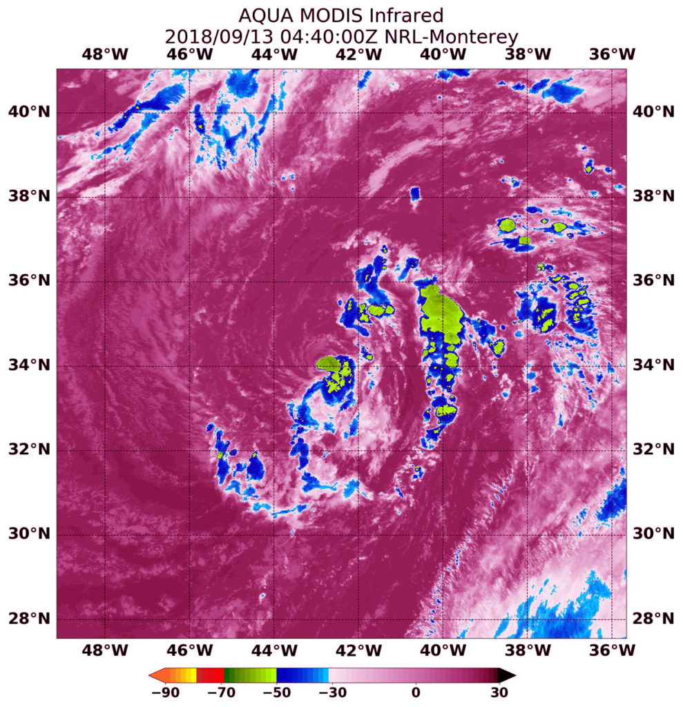
The Moderate Resolution Imaging Spectroradiometer or MODIS instrument aboard NASA’s Terra satellite captured an infrared image of Subtropical Storm Joyce at 12:40 a.m. EDT (0440 UTC) on Sept. 13. The MODIS image revealed that the low-level center is exposed to the northwest of a small patch of deep convection (strong thunderstorms that developed).
Infrared data provides temperature information. That small patch of strongest thunderstorms had cloud top temperatures as cold as minus 63 degrees Fahrenheit (minus 53 Celsius). NASA research has shown that cloud tops with temperatures that cold were high in the troposphere and have the ability to generate heavy rain.
At 11 a.m. EDT NOAA’s National Hurricane Center (NHC) noted the center of Subtropical Storm Joyce was located near latitude 33.7 degrees north and longitude 43.7 degrees west. That’s about 980 miles (1,575 km) west-southwest of the Azores Islands.
The storm is moving toward the west-southwest near 6 mph (9 kph). NHC said that a turn toward the south-southwest and then toward the south is expected later today through early Friday. A gradual turn toward the east-northeast and northeast with an increase in forward speed is expected Saturday, Sept. 15 and Sunday, Sept. 16.
Maximum sustained winds are near 40 mph (65 kph) with higher gusts. While little change in strength is forecast during the next 48 hours, Joyce could transition to a tropical storm in the next day or two.
For updated forecasts on Joyce, visit: www.nhc.noaa.gov
