Oct. 25, 2018 – GPM Satellite Shows Powerful Super Typhoon Yutu Hitting Northern Marianas
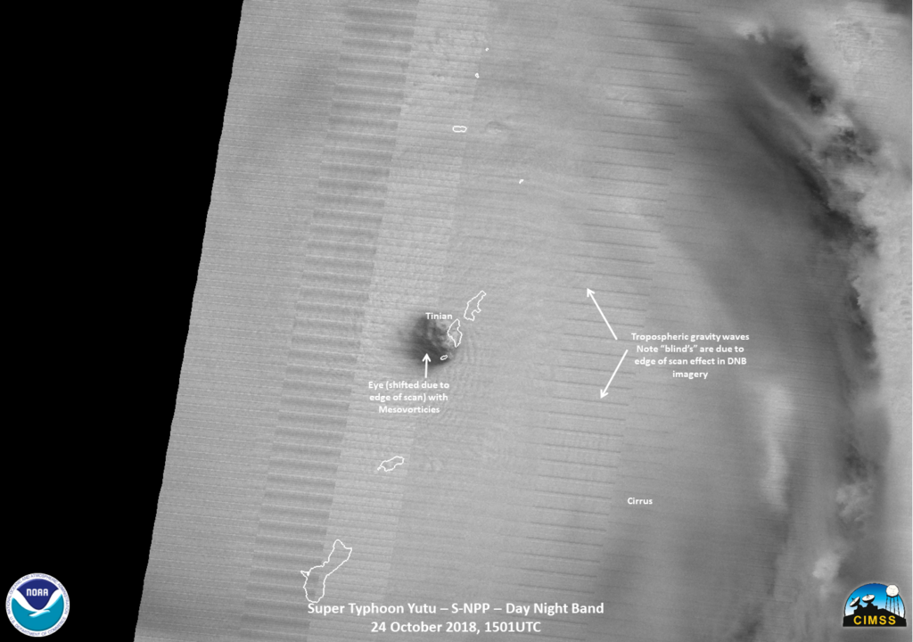
NASA’s GPM Core observatory satellite captured an image of Super Typhoon Yutu when it flew over the powerful storm just as the center was striking the central Northern Mariana Islands north of Guam.
Early Thursday, Oct. 25 local time, Super Typhoon Yutu crossed over the U.S. commonwealth of the Northern Mariana Islands. It was the equivalent of a Category 5 hurricane. The National Weather Service in Guam said it was the strongest storm to hit any part of the U.S. this year.

The Global Precipitation Measurement mission or GPM core satellite, which is managed by both NASA and the Japan Aerospace Exploration Agency, JAXA analyzed Yutu on Oct. 24 at 11:07 a.m. EDT (1507 UTC)/ 1:07 a.m. Guam Time, Oct. 25. GPM estimated rain rates within Super Typhoon Yutu fusing data from two instruments aboard: the GPM Dual-frequency Precipitation Radar or DPR, which covered the inner part of the storm, and the GPM Microwave Imager or GMI that analyzed the outer swath, just as the center was passing over the Island of Tinian.
GPM shows the inner eyewall as a near perfect ring of heavy to intense rain. Peak rain rates of up to 269 mm/hr. (~10.6 inches/hr.) were estimated within the DPR swath. The almost perfect symmetry of the inner wall is indicative of an extremely powerful storm. In fact, at the time this image was taken, Yutu’s maximum sustained winds were estimated at 155 knots (~178 mph) by the Joint Typhoon Warning Center, making it the strongest typhoon on record to strike Saipan and Tinian.

For comparison, Hurricane Michael, which devastated the northern Gulf Coast of Florida, had maximum sustained winds reported at 155 mph. At the time of the satellite flyover, GPM showed the northern eyewall passing right over Tinian and the southern tip of Saipan. GPM also reveals another interesting feature common with powerful tropical cyclones, the beginning of an eyewall replacement cycle.
After strong hurricanes and typhoons reach maturity, they often undergo an eyewall replacement cycle wherein a concentric outer eyewall forms outside and around the inner eyewall before contracting and eventually replacing the inner eyewall. This is evidenced by the emerging ring of heavy rain outside of the inner eyewall separated by the area of weaker rain.
At NASA’s Goddard Space Flight Center in Greenbelt, Maryland, a second image was created at the same time as the first and shows a unique 3D perspective of Yutu courtesy of the GPM DPR. In that image the double eyewall structure is readily apparent by the two rings of taller towers evident in the precipitation top heights. The tallest tower is located in the southeast part of the outer eyewall and is 15.7 km (9.7 miles) high.

On Oct. 25 at 11 a.m. EDT (1500 UTC), Super Typhoon Yutu had maximum sustained winds near 140 knots (161 mph/259 kph) and was still a Category 5 hurricane on the Saffir-Simpson Hurricane Wind Scale. It was centered near 6.4 degrees north and 141.8 degrees east. Super typhoon Yutu was located approximately 206 nautical miles west-northwest of Tinian and has tracked west-northwestward.
Yutu is expected to remain a very powerful super typhoon for the next few days before gradually weakening as it makes its way westward across the Philippine Sea in the general direction of Taiwan.
By Steve Lang
NASA’s Goddard Space Flight Center
