91L (Atlantic Ocean)

June 05, 2019 – NASA Estimates Heavy Texas and Louisiana Rainfall from Gulf Weather System

Earlier in the week, NOAA’s National Hurricane Center was monitoring a low-pressure system in the Gulf of Campeche that has now moved along the Texas and Louisiana coastlines, bringing heavy rainfall. On June 5, NASA used a constellation of satellites to estimate that rainfall.
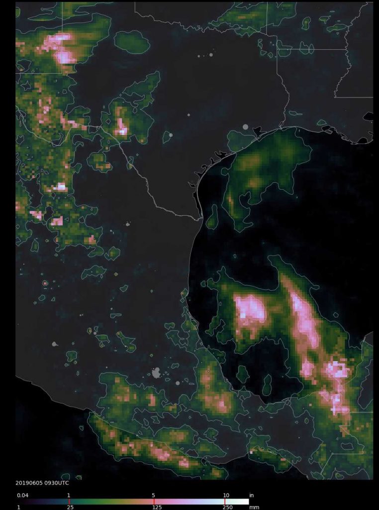
IMERG image of 91L
An IMERG precipitation product shows rainfall estimates of 10 inches between June 3 at 0000 UTC (June 2 at 8 p.m. EDT) to June 5 at 5:30 a.m. EDT (0930 UTC). Credit: NASA/JAXA, Matt Lammers

On June 5, the National Weather Service National Prediction Center in College Park, Maryland noted that there is a “High risk for flash flooding across parts of southeast Texas and southern Louisiana Today into Tonight.”

Estimating Heavy Rainfall

Forming in the Bay of Campeche on June 3, tropical disturbance 91L looked ripe to develop into a minor tropical cyclone before making landfall along the Gulf Coast of Texas, but high wind shear inhibited its development. On June 4, the National Hurricane Center dropped the chances that it would consolidate into a depression to 20 percent. On June 5, although the low-pressure area is expected to remain disorganized, it is expected to generate a lot of rainfall for the Gulf coast states.

“NASA’s IMERG data showed the tropical rainfall it brought has led to flash flooding throughout the Houston area on the morning of June 5, dumping more than 10 inches on a large region southwest of the city,” said Matt Lammers of NASA’s Goddard Space Flight Center in Greenbelt, Maryland.

The Integrated Multi-satellitE Retrievals for GPM (IMERG) creates a merged precipitation product from the Global Precipitation Measurement mission or GPM constellation of satellites. At NASA Goddard an IMERG rainfall accumulation image was created from June 3 at 0000 UTC (June 2 at 8 p.m. EDT) to June 5 at 5:30 a.m. EDT (0930 UTC). Most of the precipitation in the Houston area has fallen since the latest IMERG Early processing, so rainfall totals will be higher.

The National Weather Service noted that the moisture interacting with an upper level low moving into the Southern Plains. Heavy to excessive rainfall is likely across southeast Texas and into the Lower Mississippi Valley today, with a high risk for flash flooding where as much as 4 to 7 plus inches more of rain is in the forecast from extreme southeast Texas into southwest Louisiana.

What Is NASA’s IMERG?

NASA’s GPM or Global Precipitation Measurement mission satellite provides information on precipitation from its orbit in space. GPM is a joint mission between NASA and the Japan Aerospace Exploration Agency or JAXA. GPM also utilizes a constellation of other satellites to provide a global analysis of precipitation that are used in the IMERG calculation.

At NASA’s Goddard Space Flight Center in Greenbelt, Maryland, those data are incorporated into NASA’s IMERG or Integrated Multi-satellitE Retrievals for GPM. IMERG is used to estimate precipitation from a combination of passive microwave sensors, including the Global Precipitation Measurement (GPM) mission’s core satellite’s GMI microwave sensor and geostationary IR (infrared) data. IMERG real-time data are generated by NASA’s Precipitation Processing System every half hour and are normally available within six hours.

IMERG creates a merged precipitation product from the GPM constellation of satellites. These satellites include DMSPs from the U.S. Department of Defense, GCOM-W from the Japan Aerospace Exploration Agency (JAXA), Megha-Tropiques from the Centre National D’etudies Spatiales (CNES) and Indian Space Research Organization (ISRO), NOAA series from the National Oceanic and Atmospheric Administration (NOAA), Suomi-NPP from NOAA-NASA, and MetOps from the European Organisation for the Exploitation of Meteorological Satellites (EUMETSAT).  All of the instruments (radiometers) onboard the constellation partners are inter-calibrated with information from the GPM Core Observatory’s GPM Microwave Imager (GMI) and Dual-frequency Precipitation Radar (DPR).

Flood Watches

There is a moderate to high risk for flash flooding across parts of southeast Texas and southern Louisiana on Wednesday, June 5.

The National Weather Service in Houston/Galveston, Texas noted, “Numerous showers and thunderstorms are expected today. Rainfall will be locally heavy at times. A Flash Flood Watch is in effect through this evening. Rainfall totals will average 3 to 5 inches with isolated totals approaching 8 inches. Strong onshore winds will will produce elevated tides today and water levels at high tide could exceed 3.5 feet. Minor coastal flooding will be possible and a Coastal Flood Advisory is in effect.

Movement of the Weather System

The National Weather Service noted that “heavy to excessive rainfall threat shifts from the lower Mississippi Valley on Wednesday into the Central Gulf Coast states and eventually the U.S. Southeast by the end of the week.” For updated forecasts, visit: www.weather.gov

By Rob Gutro/with forecast information from weather.gov
NASA’s Goddard Space Flight Center

91L (Atlantic Ocean)

June 04, 2019 – NASA-NOAA Satellite Sees System 91L’s Reach into the Western Gulf of Mexico

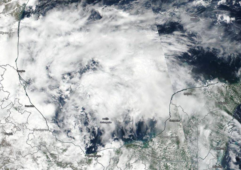
System 91L is an area of tropical low pressure located in the Bay of Campeche. On June 3, when NASA-NOAA’s Suomi NPP satellite passed the western Gulf of Mexico, it captured an image of the storm that showed its extensive reach.

Suomi NPP image of 91L
NASA-NOAA’s Suomi NPP satellite passed over the Gulf of Mexico and captured a visible image of developing low pressure System 91L on June 3, 2019. Clouds associated with the system filed the Bay of Campeche and stretched north into the western Gulf of Mexico. Credit: NASA Worldview, Earth Observing System Data and Information System (EOSDIS).

The Visible Infrared Imaging Radiometer Suite (VIIRS) instrument aboard Suomi NPP provided a visible image of the storm. The VIIRS image showed fragmented bands of thunderstorms around System 91L’s circulation center which filled the Bay of Campeche and stretched north into the western Gulf of Mexico. System 91L’s clouds extend from Mexico’s Yucatan state to the west bordering and including the states of Campeche, Tabasco, Veracruz and as far north as Tamaulipas.

At 8 a.m. EDT on June 4, NOAA’s National Hurricane Center or NHC noted that System 91L now has a 40 percent chance to form into a depression over the next two days. “Shower and thunderstorm activity associated with a broad area of low pressure located over the southwestern Gulf of Mexico has decreased since yesterday and remains disorganized. This system could briefly become a tropical depression before moving inland over northeastern Mexico later today or tonight. “

Even if System 91L doesn’t develop into a depression, it’s still packing a punch with rainfall.

The NHC noted “the disturbance will likely produce heavy rainfall over portions of eastern Mexico, southeastern Texas and the Lower Mississippi Valley during the next few days.   Interests along the Gulf coast of Mexico should monitor the progress of this system.”

By Rob Gutro 
NASA’s Goddard Space Flight Center

91L (Atlantic Ocean)

June 03, 2019 – NASA Sees Strong Storms in Developing Gulf System 91L

NASA’s Aqua satellite used infrared light to analyze the strength of storms in the developing low pressure area designated as System 91L as it moved through the Gulf of Campeche just  north of Mexico’s Yucatan Peninsula.

Aqua image of 91L
On June 3 at 4:05 a.m. EDT (0805 UTC), the MODIS instrument that flies aboard NASA’s Aqua satellite gathered infrared data on developing System 91L. Strongest thunderstorms (yellow) created a southern ring around the center from west to east, where cloud top temperatures were as cold as minus 80 degrees Fahrenheit (minus 62.2 Celsius). Credit: NASA/NRL

Infrared data provides temperature information, and the strongest thunderstorms that reach high into the atmosphere have the coldest cloud top temperatures.

On June 3 at 4:05 a.m. EDT (0805 UTC),  the Moderate Imaging Spectroradiometer or MODIS instrument that flies aboard NASA’s Aqua satellite gathered infrared data on developing System 91L. Strongest thunderstorms created a southern ring around the center from west to east, where cloud top temperatures were as cold as minus 80 degrees Fahrenheit (minus 62.2 Celsius). Cloud top temperatures that cold indicate strong storms with the potential to generate heavy rainfall. Those strongest storms were located just off the coast of the state of Campeche and the eastern part of the state of Tabasco.

On June 3 at 2 p.m. EDT, the National Hurricane Center (NHC) noted that System 91L has a medium chance to develop into a depression within the next 24 hours. NHC Forecaster Zelinsky noted in the update, “Showers and thunderstorms associated with a broad area of low pressure located over the Bay of Campeche have become a little better organized since yesterday. However, recent satellite-based wind data indicate that the circulation of the low is elongated and poorly defined.”

This system is forecast to move slowly northwestward toward the northeastern coast of Mexico, and could become a tropical cyclone before it moves inland in a day or two.

Even if System 91L does not develop into a tropical cyclone, forecasters at NHC said the  disturbance will likely produce heavy rainfall over portions of southern and eastern Mexico during the next few days. Heavy rainfall is also likely to spread over southeastern Texas and Louisiana through Thursday.

Several computer models take System 91L on a northerly path, and interests along the Gulf coast of Mexico should monitor the progress of this system.

For updated forecasts, visit: https://www.nhc.noaa.gov

By Rob Gutro
NASA’s Goddard Space Flight Center