Nov. 14, 2019 – NASA Infrared Data Shows Strength in Fengshen
Tropical Storm Fengshen’s cold cloud top temperatures revealed that the storm was maintaining strength as a strong tropical storm. Forecasters expect Fengshen will continue strengthening and reach typhoon status.

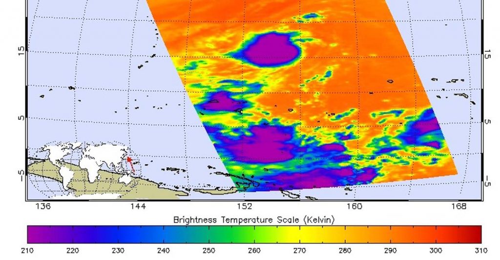
One of the ways NASA researches tropical cyclones is by using infrared data that provides temperature information. The AIRS instrument aboard NASA’s Aqua satellite captured a look at the temperatures in Fengshen which gave insight into the storm’s strength.
Cloud top temperatures provide information to forecasters about where the strongest storms are located within a tropical cyclone. Tropical cyclones do not always have uniform strength, and some sides are stronger than others. The stronger the storms, the higher they extend into the troposphere, and the colder the cloud temperatures.

On Nov. 13 at 0259 UTC (Nov. 12 at 9:59 p.m. EST) NASA’s Aqua satellite analyzed Tropical Storm Fengshen in near infrared light, using the Atmospheric Infrared Sounder or AIRS instrument. Credit: NASA JPL/Heidar ThrastarsonOn Nov. 13 at 0259 UTC (Nov. 12 at 9:59 p.m. EST) NASA’s Aqua satellite analyzed the storm using the Atmospheric Infrared Sounder or AIRS instrument. AIRS found coldest cloud top temperatures as cold as or colder than minus 63 degrees Fahrenheit (minus 53 degrees Celsius) around Fengshen’s center. NASA research has shown that cloud top temperatures that cold indicate strong storms that have the capability to create heavy rain.
By early Nov. 14, forecasters at the Joint Typhoon Warning Center noted, “Infrared imagery revealed that deep convection has re-built over the low-level circulation center with improved deep convective banding [of thunderstorms].” Microwave imagery also revealed an eye developing.
On Nov. 14, the National Weather Service (NWS) in Tiyan, Guam stated a Typhoon Warning remains in effect for Agrihan, Pagan, and Alamagan in the Commonwealth of the Northern Marianas. Damaging winds, including winds of 39 mph or more are expected after midnight with near typhoon conditions, shortly afterwards.
At 7 a.m. EDT (10 p.m. ChST, local time Guam/1200 UTC) on Nov. 14, the center of Tropical Storm Fengshen was located near latitude 17.5 degrees north and longitude 146.5 degrees east, moving west at 17 mph. That puts the center of Fengshen about 100 miles south-southeast of Agrihan, 65 miles southeast of Pagan and 45 miles east of Alamagan.
Maximum sustained winds remain near 65 mph. Fengshen is expected to intensify slowly tonight and Friday, and will likely be a typhoon by late Friday morning, after it has passed through the northern Marianas.
NWS said, “Fengshen is expected to gradually turn toward west-northwest later tonight [Nov. 14], passing very close to Alamagan Island early Friday morning [Nov. 15]. Fengshen will then turn slowly northwest on Friday as it moves away from the Marianas.”
Typhoons and hurricanes are the most powerful weather event on Earth. NASA’s expertise in space and scientific exploration contributes to essential services provided to the American people by other federal agencies, such as hurricane weather forecasting.
The AIRS instrument is one of six instruments flying on board NASA’s Aqua satellite, launched on May 4, 2002.
For updated forecasts, visit: www.nhc.noaa.gov
For the latest on Tropical Storm Fengshen: https://www.weather.gov/gum/Cyclones
