Kalmaegi – Northwestern Pacific Ocean

Nov. 21, 2019  – NASA Imagery Indicates a Dissipating Kalmaegi  

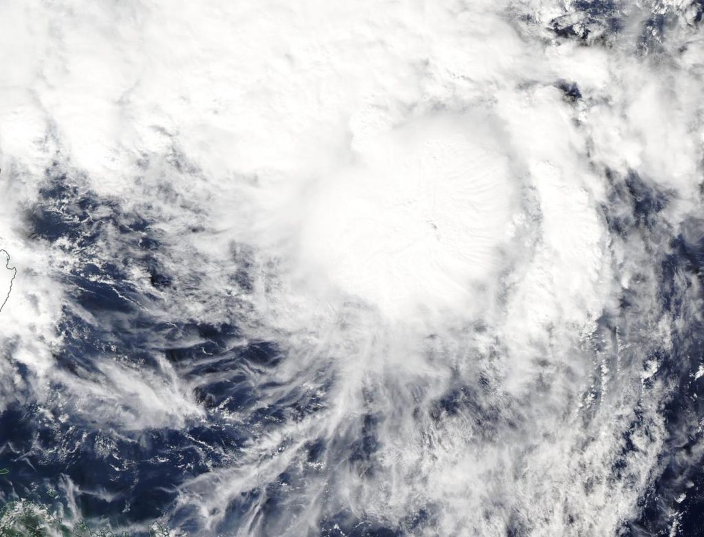
NASA’s Aqua satellite captured an image of Tropical Depression Kalmaegi in the South China Sea as it was dissipating.

Aqua image of Kalmaegi
On Nov. 21, 2019, the MODIS instrument that flies aboard NASA’s Aqua satellite provided a visible image of Tropical Depression Kalmaegi as it was dissipating in the South China Sea. Credit: NASA Worldview

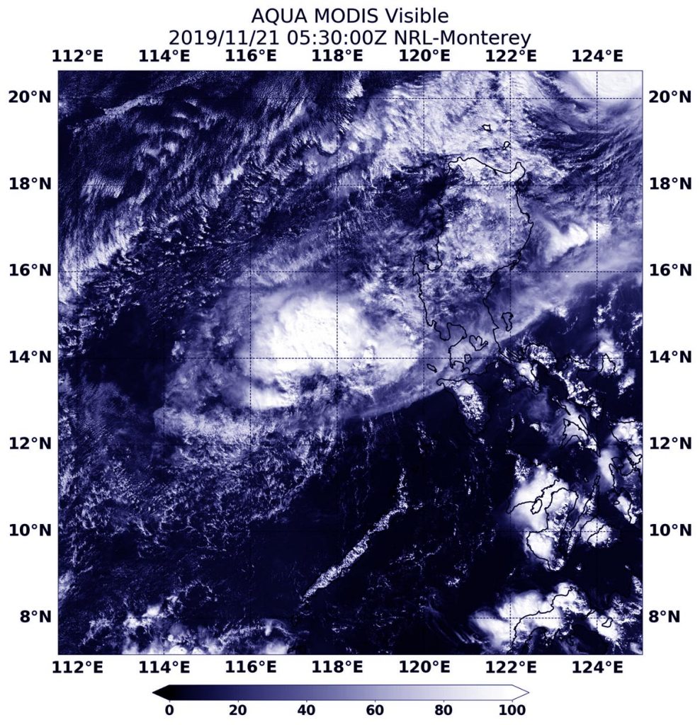
On Nov. 20, Kalmaegi had crossed over Luzon, the northernmost island of the Philippines. The storm then moved into the South China Sea where it encountered stronger wind shear, winds that can tear a storm apart. Kalmaegi is known locally in the Philippines as Tropical Cyclone Ramon.

The Joint Typhoon Warning Center issued the final warning on the storm at 4 p.m. EST (2100 UTC) on Nov. 20. At that time, Kalmaegi was located near latitude 14.1 degrees north and longitude 119.2 degrees east. That is about 109 nautical miles west-southwest of Manila, Philippines. The storm was moving to the southwest, and maximum sustained winds were down to near 75 knots (29 mph/46 kph).

On Nov. 21, the Moderate Imaging Spectroradiometer or MODIS instrument that flies aboard NASA’s Aqua satellite provided a visible image of Kalmaegi. The MODIS image revealed a shapeless storm, indicating that the storm had weakened. Kalmaegi is dissipating over the South China Sea.

NASA’s Aqua satellite is one in a fleet of NASA satellites that provide data for hurricane research.

Typhoons and hurricanes are the most powerful weather event on Earth. NASA’s expertise in space and scientific exploration contributes to essential services provided to the American people by other federal agencies, such as hurricane weather forecasting.

By Rob Gutro
NASA’s Goddard Space Flight Center

Fung-Wong – Northwestern Pacific Ocean

Nov. 20, 2019 – NASA Observes Tropical Storm Fung-Wong Organize

As Tropical Depression 28W continued organizing and developing into Tropical Storm Fung-Wong in the Philippine Sea, NASA’s Aqua satellite provided data on the storm to forecasters. In the Philippines, Fung-Wong is known as Sarah.

Aqua image of Fung-Wong
On Sept. 19, the MODIS instrument that flies aboard NASA’s Aqua satellite took this image of Tropical Storm Fung-Wong while it continued organizing in the Philippine Sea. Credit: NASA Worldview

On Nov. 20, the Moderate Resolution Imaging Spectroradiometer or MODIS instrument that flies aboard NASA’s Aqua satellite provided a visible image on Fung-Wong. The image indicated that the circulation center was more well-defined. A band of thunderstorms was also seen on the eastern side of the storm.

The shape of the storm is a clue to forecasters that a storm is either strengthening or weakening. If a storm takes on a more rounded shape it is getting more organized and strengthening. Conversely, if it becomes less rounded or elongated, it is a sign the storm is weakening. Fung-Wong has appeared to become more symmetrical in the MODIS imagery, indicating it is getting better organized.

In addition, the Joint Typhoon Warning Center noted that animated enhanced infrared satellite imagery suggests the low-level circulation center is obscured under central dense overcast. The deep convection (bands of thunderstorms) appears to have begun wrapping completely around the low-level center of circulation.

At 10 a.m. EST (1500 UTC) on Nov. 20, the center of Tropical Storm Fung-Wong was located near latitude 19.5 degrees north and longitude 126.4 degrees east. That puts the center about 432 nautical miles southeast of Taipei, Taiwan. Maximum sustained winds were near 45 knots (52 mph/83 kph). Fung-Wong is moving to the north-northwest.

The Joint Typhoon Warning Center or JTWC noted that Fung-Wong would move northwest toward Taiwan. The system is forecast to strengthen to 55 knots (63 mph/102 kph) within 24 hours before weakening rapidly on approach to Taiwan.

The Central Weather Bureau of Taiwan is keeping track of the storm and will provide watches and warnings.

Typhoons and hurricanes are the most powerful weather event on Earth. NASA’s expertise in space and scientific exploration contributes to essential services provided to the American people by other federal agencies, such as hurricane weather forecasting.

For Taiwan Central Weather Bureau updates, visit https://www.cwb.gov.tw/V7e/prevent/typhoon/ty.htm

By Rob Gutro
NASA’s Goddard Space Flight Center

Kalmaegi – Northwestern Pacific Ocean

Nov. 20, 2019 – NASA Tracks Typhoon Kalmaegi Affecting Northern Philippines

NASA’s Terra satellite captured an image of Typhoon Kalmaegi as it moved into the Luzon Strait and continued to affect the northern Philippines.

Aqua image of Kalmaegi
On Nov. 19, 2019, the MODIS instrument that flies aboard NASA’s Terra satellite provided a visible image of Typhoon Kalmaegi near the Luzon Strait and northern Philippines. Credit: NASA Worldview

On Nov. 19, Kalmaegi’s western edge was in the Luzon Strait, while its southern quadrant was over the northern Philippines. The Luzon Strait is located between Taiwan and Luzon, Philippines. The strait connects the Philippine Sea to the South China Sea in the northwestern Pacific Ocean.

Kalmaegi is known locally in the Philippines as Tropical Cyclone Ramon, and there are many warning signals in effect for the northern Philippines.

Signal #3 is in effect for the Luzon provinces of Northern portion of Cagayan (Santa Praxedes), Claveria, Sanchez Mira, Pamplona, Abulug, Ballesteros, Aparri, Calayan, Camalaniugan, Buguey, Santa Teresita, Gonzaga and Santa Ana. Signal #2 is in effect for the Luzon provinces of Batanes, Apayao, Kalinga, Abra, Ilocos Norte & Sur and the rest of Cagayan. Signal #1 is in effect for the Luzon provinces of Northern portion of Isabela (Sta. Maria), San Pablo, Maconacon, Cabagan, Sto. Tomas, Quezon, Delfin Albano, Tumauini, Divilacan, Quirino, Roxas, Mallig, San Manuel, Burgos, Gamu and Ilagan City, Mountain Province, Benguet, Ifugao, La Union, and Pangasinan.

On Nov. 19, the Moderate Resolution Imaging Spectroradiometer or MODIS instrument that flies aboard NASA’s Terra satellite provided a visible image of Kalmaegi. The MODIS image showed the hint of an oblong eye covered by high clouds. Forecasters at the Joint Typhoon Warning Center noted that eye had collapsed due to deteriorating environmental conditions.

At 10 a.m. EST (1500 UTC), Typhoon Kalmaegi was located near latitude 19.4 degrees north and longitude 122.5 degrees east. about 301 nautical miles north-northeast of Manila, Philippines. The storm is barely moving, however. It is moving to the west at 1 knot per hour (1 mph/1.8 kph). Maximum sustained winds were near 75 knots (86 mph/139 kph).

Kalmaegi is turning toward a southwesterly course, which will take it across northwestern Luzon (northern Philippines). The storm will start to weaken, then later weaken rapidly, as it moves into the South China Sea.

NASA’s Terra satellite is one in a fleet of NASA satellites that provide data for hurricane research.

Typhoons and hurricanes are the most powerful weather event on Earth. NASA’s expertise in space and scientific exploration contributes to essential services provided to the American people by other federal agencies, such as hurricane weather forecasting.

By Rob Gutro
NASA’s Goddard Space Flight Center

Sebastien – Atlantic Ocean

Nov. 20, 2019 – NASA Estimates Tropical Storm Sebastien’s Rainfall Rates

NASA found moderate rainfall occurring over a large area in Tropical Storm Sebastien, as it moves through the Atlantic Ocean.

IMERG data of Sebastien
When IMERG analyzed Tropical Storm Sebastien on Nov. 19, calculations indicated moderate rainfall occurring. Rainfall rates around 17.0 mm or 0.7 inches per hour (red) were falling east of the low-level center. Lighter rainfall rates appear in yellow. Credit: JAXA/NASA Worldview

NASA has the unique ability to measure and calculate rainfall rates in storms from the Global Precipitation Measurement mission or GPM satellite. That data is combined with data from other satellites to form NASA’s Integrated Multi-satellitE Retrievals for GPM (IMERG) forecast .

The near-real time rain estimate comes from the NASA’s IMERG algorithm, which combines observations from a fleet of satellites, in near-real time, to provide near-global estimates of precipitation every 30 minutes. By combining NASA precipitation estimates with other data sources, we can gain a greater understanding of the major storms that affect our planet.

When IMERG analyzed Tropical Storm Sebastien on Nov. 19, calculations indicated moderate rainfall occurring. Rainfall rates around 17.0 mm or 0.7 inches per hour were falling east of the center. Sebastien continues to struggle with dry air and northwesterly wind shear, with satellite imagery showing an exposed low-level center to the west of the deep convection.

Sebastien’s Status on Nov. 20

NOAA’s National Hurricane Center or NHC reported on Nov. 20 at 5 a.m. EST (0900 UTC), the center of Tropical Storm Sebastien was located near latitude 21.0 degrees north and longitude 61.0 degrees west. That is about 235 miles (380 km) northeast of the Northern Leeward Islands.

Sebastien is moving toward the northwest near 8 mph (13 kph). A turn to the north-northwest and then north is expected later today. A turn toward the northeast with an increase in forward speed is expected tonight and Thursday. Maximum sustained winds have increased to near 50 mph (85 kph) with higher gusts. Some strengthening is forecast during the next 48 hours. Tropical-storm-force winds extend outward up to 150 miles (240 km) from the center. The estimated minimum central pressure is 1002 millibars.

 About IMERG

IMERG fills in the “blanks” between weather observation stations. IMERG satellite-based rain estimates can be compared to that from a National Weather Service ground radar.  Such good detection of large rain features in real time would be impossible if the IMERG algorithm merely reported the precipitation observed by the periodic overflights of various agencies’ satellites.  Instead, what the IMERG algorithm does is “morph” high-quality satellite observations along the direction of the steering winds to deliver information about rain at times and places where such satellite overflights did not occur.  Information morphing is particularly important over the majority of the world’s surface that lacks ground-radar coverage.

Sebastien’s Fate

Sebastien is expected to become an extratropical cyclone in a couple of days and be absorbed by a cold front on Friday, Nov. 22.

Hurricanes are the most powerful weather event on Earth. NASA’s expertise in space and scientific exploration using a fleet of satellites contributes to essential services provided to the American people by other federal agencies, such as hurricane weather forecasting.

For more information about NASA’s IMERG, visit: https://pmm.nasa.gov/gpm/imerg-global-image

For local forecasts, visit: www.weather.gov

By Rob Gutro
NASA’s Goddard Space Flight Center


Kalmaegi – Northwestern Pacific Ocean

Nov. 19, 2019 – NASA Tracks Typhoon Kalmaegi Affecting Northern Philippines

NASA’s Terra satellite captured an image of Typhoon Kalmaegi as it moved into the Luzon Strait and continued to affect the northern Philippines.

Suomi NPP image of Kalmaegi
On Nov. 19, 2019, the MODIS instrument that flies aboard NASA’s Terra satellite provided a visible image of Typhoon Kalmaegi near the Luzon Strait and northern Philippines. Credit: NASA Worldview

On Nov. 19, Kalmaegi’s western edge was in the Luzon Strait, while its southern quadrant was over the northern Philippines. The Luzon Strait is located between Taiwan and Luzon, Philippines. The strait connects the Philippine Sea to the South China Sea in the northwestern Pacific Ocean.

Kalmaegi is known locally in the Philippines as Tropical Cyclone Ramon, and there are many warning signals in effect for the northern Philippines.

Signal #3 is in effect for the Luzon provinces of Northern portion of Cagayan (Santa Praxedes), Claveria, Sanchez Mira, Pamplona, Abulug, Ballesteros, Aparri, Calayan, Camalaniugan, Buguey, Santa Teresita, Gonzaga and Santa Ana. Signal #2 is in effect for the Luzon provinces of Batanes, Apayao, Kalinga, Abra, Ilocos Norte & Sur and the rest of Cagayan. Signal #1 is in effect for the Luzon provinces of Northern portion of Isabela (Sta. Maria), San Pablo, Maconacon, Cabagan, Sto. Tomas, Quezon, Delfin Albano, Tumauini, Divilacan, Quirino, Roxas, Mallig, San Manuel, Burgos, Gamu and Ilagan City, Mountain Province, Benguet, Ifugao, La Union, and Pangasinan.

On Nov. 19, the Moderate Resolution Imaging Spectroradiometer or MODIS instrument that flies aboard NASA’s Terra satellite provided a visible image of Kalmaegi. The MODIS image showed the hint of an oblong eye covered by high clouds. Forecasters at the Joint Typhoon Warning Center noted that eye had collapsed due to deteriorating environmental conditions.

At 10 a.m. EST (1500 UTC), Typhoon Kalmaegi was located near latitude 19.4 degrees north and longitude 122.5 degrees east about 301 nautical miles north-northeast of Manila, Philippines. The storm is barely moving, however. It is moving to the west at 1 knot per hour (1 mph/1.8 kph). Maximum sustained winds were near 75 knots (86 mph/139 kph).

Kalmaegi is taking a southwesterly course, which will take it across northwestern Luzon (northern Philippines). The storm will start to weaken, and later rapidly weaken, as it moves into the South China Sea.

NASA’s Terra satellite is one in a fleet of NASA satellites that provide data for hurricane research.

Typhoons and hurricanes are the most powerful weather event on Earth. NASA’s expertise in space and scientific exploration contributes to essential services provided to the American people by other federal agencies, such as hurricane weather forecasting.

By Rob Gutro
NASA’s Goddard Space Flight Center

Sebastien – Atlantic Ocean

Nov. 19, 2019 – NASA Identifies New Atlantic Tropical Storm Sebastien

NASA’s Aqua satellite captured an image of newly formed Tropical Storm Sebastien, located northeast of the Leeward Islands in the Atlantic Ocean.

Aqua image of Sebastien
On Nov. 19, 2019, the MODIS instrument that flies aboard NASA’s Aqua satellite provided a visible image of newly formed Tropical Storm Sebastien, just east of the Northern Leeward Islands in the Atlantic Ocean. Credit: NASA Worldview

On Nov. 19, the Moderate Resolution Imaging Spectroradiometer or MODIS instrument that flies aboard NASA’s Aqua satellite provided a visible image of Sebastien. The MODIS image showed that the overall cloud pattern of the disturbance has improved since yesterday, Nov. 18, and that the low-pressure area has become well-defined.

NOAA’s National Hurricane Center or NHC noted at 11 a.m. EST (1500 UTC), the center of Tropical Storm Sebastien was located near latitude 20.1 north and longitude 58.7 west. That is about 275 miles (445 km) northeast of the Leeward Islands.

Sebastien is moving toward the north-northwest near 8 mph (13 kph). A turn to the north is expected on Wednesday followed by a turn to the northeast and an increase in forward speed Wednesday night. Maximum sustained winds are near 45 mph (75 kph) with higher gusts. Some slight strengthening is possible over the next day or so. The estimated minimum central pressure is 1008 millibars.

Sebastien is expected to become absorbed by a cold front in a couple of days.

NASA’s Aqua satellite is one in a fleet of NASA satellites that provide data for hurricane research.

Hurricanes are the most powerful weather event on Earth. NASA’s expertise in space and scientific exploration contributes to essential services provided to the American people by other federal agencies, such as hurricane weather forecasting.

For updated forecasts, visit: https://www.nhc.noaa.gov

By Rob Gutro
NASA’s Goddard Space Flight Center

Fengshen – Northwestern Pacific Ocean

Nov. 18, 2019 – NASA Finds Light Rain in Fading Tropical Depression Fengshen

A NASA analysis of rainfall rates shows that the once mighty Fengshen is now a depression devoid of heavy rainfall.

GPM image of Fengshen
The GPM core satellite passed over Tropical Depression Fengshen in the Northwestern Pacific Ocean on Nov. 18 at 1:56 a.m. EST (0656 UTC) and found a few areas of light rain (blue) falling at a rate of 0.4 inches (10 mm) per hour. Credit: NASA/JAXA/NRL

On Nov. 17 at 1 p.m. EST (1800 UTC), the Joint Typhoon Warning Center noted that  Tropical Depression Fengshen was located near latitude 24.8 degrees north and longitude 157.9 east, approximately 585 nautical miles northwest of Wake Island, and had tracked southeastward. Maximum sustained surface winds were estimated at 30 knots (34.5 mph/55.5 kph) and weakening.

NASA has the unique capability of peering under the clouds in storms and measuring the rate in which rain is falling. Global Precipitation Measurement mission or GPM core passed over Fengshen from its orbit in space and measured rainfall rates throughout the storm on Nov. 18 at 1:56 a.m. EST (0656 UTC). GPM found a few areas of light rain (blue) falling at a rate of 0.4 inches (10 mm) per hour remained in the weakening system.

Fengshen is expected to become a remnant low pressure system later on Nov. 18.

Typhoons and hurricanes are the most powerful weather event on Earth. NASA’s expertise in space and scientific exploration contributes to essential services provided to the American people by other federal agencies, such as hurricane weather forecasting.

Both the Japan Aerospace Exploration Agency, JAXA and NASA manage GPM.

By Rob Gutro
NASA’s Goddard Space Flight Center

Kalmaegi – Northwestern Pacific Ocean

Nov. 18, 2019 – NASA Finds Heavy Rain Potential in Typhoon Kalmaegi

NASA analyzed the cloud top temperatures in Typhoon Kalmaegi using infrared light to determine the strength of the storm. Kalmaegi is known locally as Ramon in the Philippines where warnings are in effect.

AIRS image of Kalmaegi
On Nov. 18 at 4:59 UTC (Nov. 17 at 11:59 p.m. EST) NASA’s Aqua satellite analyzed Kalmaegi using the AIRS instrument. AIRS showed the strongest storms with coldest cloud top temperatures (purple) as cold as or colder than 210 Kelvin minus 81 degrees Fahrenheit (minus 63.1 degrees Celsius) around the center and over northeastern Luzon, Philippines. Credit: NASA JPL/Heidar Thrastarson

Kalmaegi has triggered warnings in the Philippines. Philippines tropical cyclone wind signals include Signal #2 for the Luzon provinces of Cagayan (including Babuyan Islands), northern portion of Isabela (Sta Maria), San Pablo, Maconacon, Cabagan, Sto Tomas, Quezon, Delfin Albano, Tumauini and Divilacan, Apayao, Kalinga and Ilocos Norte. In addition, Signal #1 is in effect for the Luzon provinces of Batanes, Ilocos Sur, Abra, Mountain Province, Benguet, Ifugao, La Union, Northern Aurora (Dilasag), Casiguran and Dinalungan and the rest of Isabela.

One of the ways NASA researches tropical cyclones is using infrared data that provides temperature information. Cloud top temperatures identify where the strongest storms are located. The stronger the storms, the higher they extend into the troposphere, and the colder the cloud temperatures.

On Nov. 18 at 4:59 UTC (Nov. 17 at 11:59 p.m. EST) NASA’s Aqua satellite analyzed the storm using the Atmospheric Infrared Sounder or AIRS instrument. The AIRS imagery showed the strongest storms circling the center of circulation, and over the northeastern side of Luzon, northern Philippines. In those areas, AIRS found coldest cloud top temperatures as cold as or colder 210 Kelvin minus 81 degrees Fahrenheit (minus 63.1 degrees Celsius). NASA research has shown that cloud top temperatures that cold indicate strong storms that have the capability to create heavy rain.

Tropical cyclones do not always have uniform strength, and some sides have stronger sides than others, so knowing where the strongest sides of the storms are located helps forecasters. NASA then provides data to tropical cyclone meteorologists so they can incorporate it in their forecasts.

At 10 a.m. EST (1500 UTC) on Nov. 19, the Joint Typhoon Warning Center or JTWC noted that the center of Kalmaegi was located near latitude 18.9 degrees north and longitude 123.0 degrees east. That puts the center about 282 nautical miles north-northeast of Manila, Philippines. Maximum sustained winds were near 75 knots (86 mph/139 kph).

Kalmaegi is turning into a westerly then southwesterly course, rounding the northern areas of Luzon. The storm will start to weaken as it moves southwest into the South China Sea.

Typhoons and hurricanes are the most powerful weather event on Earth. NASA’s expertise in space and scientific exploration contributes to essential services provided to the American people by other federal agencies, such as hurricane weather forecasting.

The AIRS instrument is one of six instruments flying on board NASA’s Aqua satellite which launched on May 4, 2002.

By Rob Gutro
NASA’s Goddard Space Flight Center  

Raymond – Eastern Pacific Ocean

Nov. 18, 2019 – Raymond Became a Remnant Low Pressure Area

Former Tropical Storm Raymond weakened to a remnant low pressure area on Sunday, Nov. 17.

On Nov. 17 at 10 a.m. EDT, NOAA’s National Hurricane Center issued the final advisory on Raymond. At that time, the center of Post-Tropical Cyclone Raymond was located near latitude 19.1 north and longitude 111.1 west.  Maximum sustained winds were near 30 mph (45 kp h) with higher gusts.

Raymond’s remnants have moved near the southern tip of the Baja California peninsula today, Nov. 18, and are dissipating.

By Rob Gutro
NASA’s Goddard Space Flight Center


21E – Eastern Pacific Ocean

Nov. 18, 2019 – NASA Finds Light Rain in Fading Tropical Depression 21E

Tropical Depression 21E never matured into a tropical storm and a NASA analysis of rainfall rates show the storm won’t have that chance.

GPM image of 21E
The GPM core satellite passed over Tropical Depression 21E in the Eastern Pacific Ocean on Nov. 18 at 0046 UTC (Nov. 17 at 7:46 p.m. EST) and found a few areas of light rain (blue) falling at a rate of 0.4 inches (10 mm) per hour and one small area of heavy rain (orange) where rain was falling at a rate of 1 inch (25 mm) per hour. Credit: NASA/JAXA/NRL

NASA has the unique capability of peering under the clouds in storms and measuring the rate in which rain is falling. Global Precipitation Measurement mission or GPM core passed over Tropical Depression 21E (TD21E) from its orbit in space and measured rainfall rates throughout the storm.

TD21E formed on Saturday, Nov. 16 and maintained depression status over the weekend.

The GPM’s core satellite passed over TD21E in the Arabian Sea, Eastern Pacific Ocean on Nov. 18 at 0046 UTC (Nov. 17 at 7:46 p.m. EST) and found a few areas of light rain falling at a rate of 0.4 inches (10 mm) per hour. There was one small area north of the center where heavy rain was falling at a rate of 1 inch (25 mm) per hour, but forecasters said that area “doesn’t seem to be directly associated with the depression’s circulation.” Forecasters incorporate the rainfall data into their forecasts.

NOAA’s National Hurricane Center or NHC noted at 4 a.m. EST (0900 UTC), the center of TD21E was located near latitude 12.2 north, longitude 105.0 west and is located about 470 miles (760 km) south of Manzanillo, Mexico.

The depression is moving toward the northwest near 7 mph (11 kph). A westward motion at a slower forward speed is expected for the next couple of days.

Maximum sustained winds are near 30 mph (45 kph) with higher gusts. The estimated minimum central pressure is 1007 millibars.

The depression is expected to become a remnant by early Tuesday and dissipate by Wednesday night or Thursday, Nov. 21.

Hurricanes are the most powerful weather event on Earth. NASA’s expertise in space and scientific exploration contributes to essential services provided to the American people by other federal agencies, such as hurricane weather forecasting.

Both the Japan Aerospace Exploration Agency, JAXA and NASA manage GPM.

By Rob Gutro
NASA’s Goddard Space Flight Center