Halong – Northwestern Pacific Ocean

Nov. 04, 2019 – NASA Provides an Infrared Analysis of Typhoon Halong

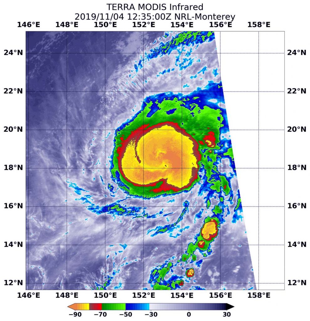
Typhoon Halong continued to strengthen in the Northwestern Pacific Ocean as NASA’s Terra satellite passed overhead. Infrared imagery from an instrument aboard Terra revealed very high, powerful storms with very cold cloud top temperatures circling the center as well as in a band of thunderstorms west of the center.
Terra image of Halong
On Nov. 4 at 7:35 a.m. EDT (1235 UTC) the MODIS instrument that flies aboard NASA’s Terra satellite showed areas around Halong’s center as well as in a band of thunderstorms west of the center (in yellow), where cloud top temperatures were as cold as or colder than minus 80 degrees Fahrenheit (minus 62.2 Celsius). Credit: NASA/NRL

Halong developed on Nov. 2 from a low-pressure area designated as System 99W. The storm consolidated into a tropical storm later that day. On Nov. 3, Halong intensified further and became a typhoon.

Tropical cyclones are made of up hundreds of thunderstorms, and infrared data can show where the strongest storms are located. They can do that because infrared data provides temperature information, and the strongest thunderstorms that reach highest into the atmosphere have the coldest cloud top temperatures.

On Nov. 4 at 7:35 a.m. EDT (1235 UTC), the Moderate Imaging Spectroradiometer or MODIS instrument that flies aboard NASA’s Terra satellite used infrared light to analyze the strength of storms within the tropical cyclone. MODIS found those strongest storms  in a very large area circling the center of circulation and in a thick band of storms west of center, where cloud top temperatures were as cold as or colder than minus 80 degrees Fahrenheit (minus 62.2 Celsius). NASA research has found that cloud top temperatures that cold indicate strong storms with the potential to generate heavy rainfall.

On Nov. 4 at 4 a.m. EDT (0900 UTC), Typhoon Halong had maximum sustained winds near 80 knots (92 mph /148 kph). It was located near latitude 17.9 degrees north and longitude 153.1 degrees east, about 381 nautical miles south of Minami Tori Shima, Japan. Halong was moving to the northwest.

Forecasters at the Joint Typhoon Warning Center expect Halong will move northwest, while strengthening further over the open waters of the Northwestern Pacific Ocean. Fortunately, Halong does not pose an immediate threat to land areas.

Hurricanes are the most powerful weather event on Earth. NASA researches these storms to determine how they rapidly intensify, develop and behave. NASA’s expertise in space and scientific exploration contributes to essential services provided to the American people by other federal agencies, such as hurricane weather forecasting.

By Rob Gutro
NASA’s Goddard Space Flight Center

Maha – Northern Indian Ocean

Nov. 04, 2019 – NASA Provides an Infrared Analysis of Tropical Cyclone Maha   

NASA infrared imagery revealed Tropical Cyclone Maha was still a powerful storm as it continued moving through the Arabian Sea in the Northern Indian Ocean.

Aqua image of Maha
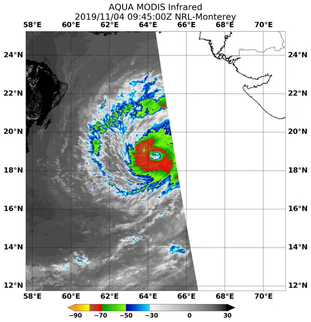
On Nov. 4 at 4:45 a.m. EDT (0945 UTC) the MODIS instrument that flies aboard NASA’s Aqua satellite showed areas (in red) around Maha’s center where cloud top temperatures were as cold as  minus 80 degrees Fahrenheit (minus 62.2 Celsius). Credit: NASA/NRL

On Nov. 4 at 4:45 a.m. EDT (0945 UTC the Moderate Imaging Spectroradiometer or MODIS instrument that flies aboard NASA’s Aqua satellite used infrared light to analyze the strength of the storms within the tropical cyclone. NASA researches these storms to determine how they rapidly intensify, develop and behave.

Tropical cyclones are made of up hundreds of thunderstorms, and infrared data can show where the strongest storms are located. They can do that because infrared data provides temperature information, and the strongest thunderstorms that reach highest into the atmosphere have the coldest cloud top temperatures.

MODIS found those strongest storms were circling the center of circulation where cloud top temperatures were as cold as minus 80 degrees Fahrenheit (minus 62.2 Celsius). NASA research has found that cloud top temperatures that cold indicate strong storms with the potential to generate heavy rainfall.

On Nov. 4 at 4 a.m. EDT (0900 UTC), Tropical Cyclone Maha had maximum sustained winds near 100 knots (115 mph /185 kph). It was located near latitude 18.5 degrees north and longitude 64.4 degrees east, about 405 miles south-southwest of Karachi, Pakistan. Maha was moving to the northwest.

Forecasters at the Joint Typhoon Warning Center noted that Maha will move west-northwest and continue to strengthen. The storm will then turn to the east and weaken rapidly, before making landfall in northwestern India.

Hurricanes are the most powerful weather event on Earth. NASA’s expertise in space and scientific exploration contributes to essential services provided to the American people by other federal agencies, such as hurricane weather forecasting.

By Rob Gutro
NASA’s Goddard Space Flight Center

Maha – Northern Indian Ocean

Nov. 01, 2019 – NASA Finds Tropical Storm Maha’s Heavy Rain Potential Over Lakshadweep

Tropical Cyclone Maha continued to move north along the southwestern coast of India when NASA’s Aqua satellite passed overhead and analyzed the cloud top temperatures. Satellite imagery showed the storms with the greatest rainfall potential were over the Lakshadweep islands.

Aqua image of Maha
On Oct. 31 at 4:29 a.m. EDT (0829 UTC) NASA’s Aqua satellite analyzed Tropical Cyclone Maha using the AIRS instrument. AIRS showed the strongest storms were located over the Lakshadweep Islands where the coldest cloud top temperatures as cold as or colder than 210 Kelvin (purple) minus 81 degrees Fahrenheit (minus 63.1 degrees Celsius) around the center. Credit: NASA JPL/Heidar Thrastarson

One of the ways NASA researches tropical cyclones is using infrared data that provides temperature information. Cloud top temperatures identify where the strongest storms are located. The stronger the storms, the higher they extend into the troposphere, and the colder the cloud temperatures.

Tropical cyclones do not always have uniform strength, and some sides are stronger than others, so knowing where the strongest sides of the storms are located helps forecasters. NASA then provides data to tropical cyclone meteorologists so they can incorporate it in their forecasts. The AIRS imagery appeared to show those strongest storms were on the eastern side of Maha.

On Oct. 31 at 4:29 a.m. EDT (0829 UTC) NASA’s Aqua satellite analyzed the storm using the Atmospheric Infrared Sounder or AIRS instrument. The AIRS imagery showed the strongest storms were located over the Lakshadweep Islands. Lakshadweep is a group of about three dozen islands scattered over about 30,000 square miles (78,000 square km) in the Arabian Sea off the southwestern coast of India.

AIRS found coldest cloud top temperatures as cold as or colder than 210 Kelvin (minus 81 degrees Fahrenheit  or minus 63.1 degrees Celsius) around the center as well as east of center. NASA research has shown that cloud top temperatures that cold indicate strong storms that have the capability to create heavy rain.

At 11 a.m. EDT (1500 UTC) on Nov. 1, the Joint Typhoon Warning Center or JTWC noted that the center of Maha was located near latitude 16.0 degrees north latitude and longitude 69.0 degrees east longitude. That puts the center about 555 nautical miles south-southeast of Karachi, Pakistan. Maximum sustained winds were near 45 knots (52 mph/83 kph).

Maha is forecast to continue moving northwest and parallel to the west coast of the Indian peninsula. After three days, the storm is forecast to turn west into the central Arabian Sea.

Hurricanes are the most powerful weather event on Earth. NASA’s expertise in space and scientific exploration contributes to essential services provided to the American people by other federal agencies, such as hurricane weather forecasting.
The AIRS instrument is one of six instruments flying on board NASA’s Aqua satellite, launched on May 4, 2002.

By Rob Gutro
NASA’s Goddard Space Flight Center  

Rebekah – North Atlantic Ocean

Nov. 01, 2019 – NASA Satellite Imagery Finds Rebekah Now Post-Tropical

NASA’s Terra Satellite provided a visible image of Post-Tropical Cyclone Rebekah as it continued moving in an easterly direction through the North Atlantic Ocean. Satellite data has confirmed that Rebekah is now a post-tropical cyclone.

Terra image of Rebekah
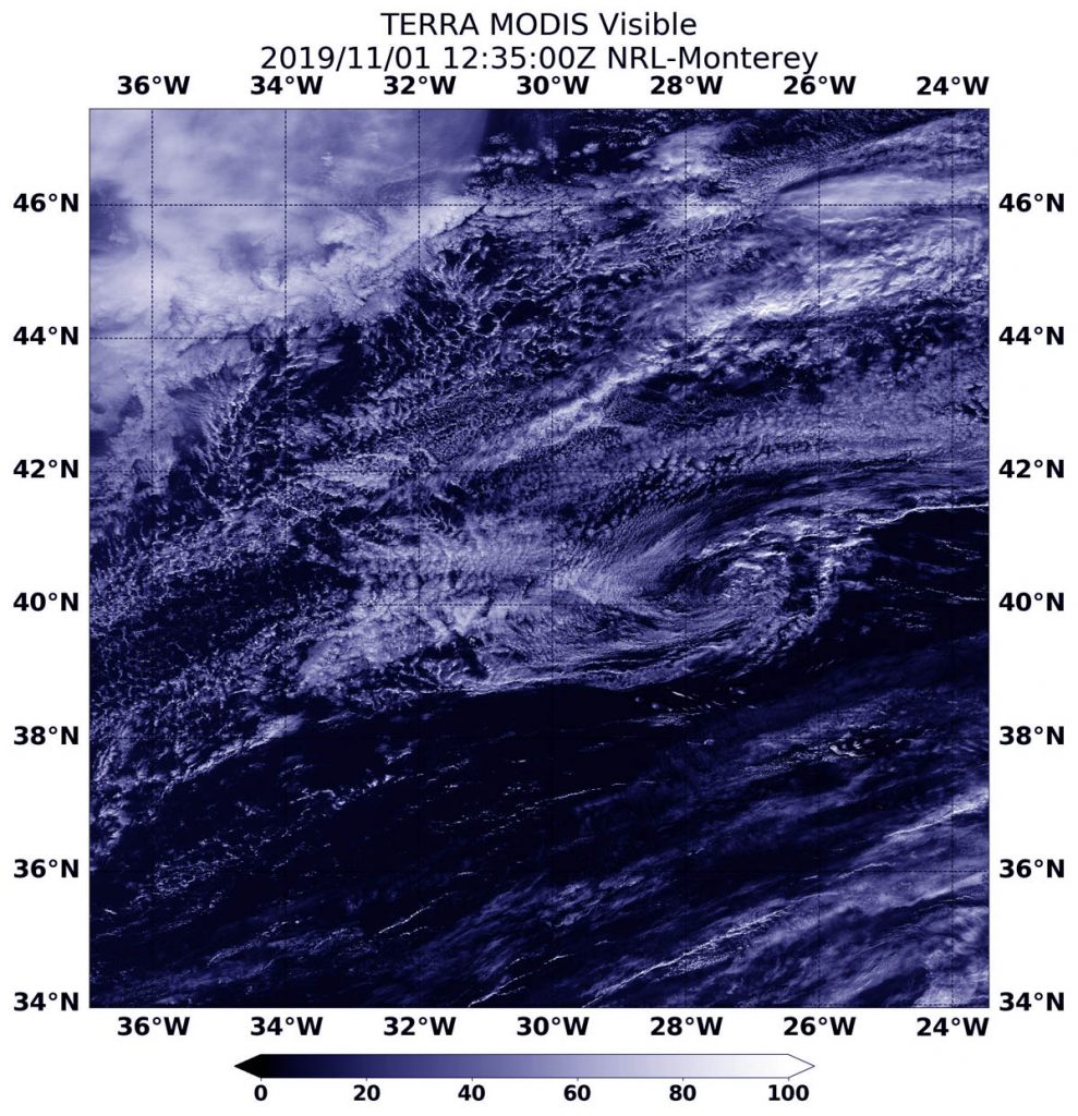
On Nov. 1 at 08:35 a.m. EDT (12:35 UTC), the MODIS instrument that flies aboard NASA’s Terra provided a visible image of Post-Tropical Cyclone Rebekah moving through the North Atlantic Ocean. Rebekah was devoid of strong thunderstorm development and appeared as a circulation of wispy clouds. Credit: NASA/NRL

At 5 a.m. EDT (0900 UTC) on Nov. 1, the center of Post-Tropical Cyclone Rebekah was located near latitude 40.6 degrees north and longitude 29.0 degrees west. That puts the center about 140 miles (225 km) north of Faial Island in the central Azores islands. The Azores are an archipelago or group of islands that are an autonomous region of Portugal.

The post-tropical cyclone is moving toward the east near 20 mph (31 kph) and this motion is expected to continue through tonight. Maximum sustained winds have decreased to near 35 mph (55 kph) with higher gusts. The estimated minimum central pressure is 1005 millibars. The National Hurricane Center (NHC) issued the final advisory on the system and Rebekah was designated post-tropical.

On Nov. 1 at 08:35 a.m. EDT (12:35 UTC), the Moderate Resolution Imaging Spectroradiometer or MODIS instrument that flies aboard NASA’s Terra satellite provided a visible image of Rebekah just after it was designated a post-tropical cyclone. The image revealed that Rebekah has degenerated to a remnant low-pressure area because the circulation was devoid of deep convection and strong thunderstorms. Rebekah appeared as a circulation of wispy clouds in the Terra satellite image.

A Post-Tropical Storm is a generic term for a former tropical cyclone that no longer possesses sufficient tropical characteristics to be considered a tropical cyclone. Former tropical cyclones can become fully extratropical, subtropical, or remnant lows, which are three classes of post-tropical cyclones. In any case, they no longer possesses sufficient tropical characteristics to be considered a tropical cyclone. However, post-tropical cyclones can continue carrying heavy rains and high winds.

NOAA’s National Hurricane Center discussion noted that Rebekah is starting to merge with a weak frontal system over the northeastern Atlantic. The remnants of Rebekah are expected to weaken to a trough or elongated area of low pressure between 12 and 24 hours.

Hurricanes are the most powerful weather event on Earth. NASA’s expertise in space and scientific exploration contributes to essential services provided to the American people by other federal agencies, such as hurricane weather forecasting.

For updated forecasts, visit: www.nhc.noaa.gov

By Rob Gutro
NASA’s Goddard Space Flight Center