Dec. 02, 2019 – Satellite Imagery shows Typhoon Kammuri’s Center Obscured
NASA-NOAA’s Suomi NPP or S-NPP satellite passed over the Philippine Sea in the Northwestern Pacific Ocean and found Typhoon Kammuri’s eye obscured.

Since Kammuri has now entered the Philippine Area of Responsibility, defined by the World Meteorological Organization, the Philippine Atmospheric, Geophysical and Astronomical Services Administration (PAGASA), it has been assigned a parallel name of “Tisoy.” The rational is that it is felt that Filipinos will respond more to familiar names and that it helps to underscore that these named weather disturbances pose a direct threat to the country. However, for the purposes of these discussions, the international recognized name designated by the Regional Specialized Meteorological Center (RSMC) Tokyo –Kammuri–will be used.
The Philippine Atmospheric, Geophysical and Astronomical Services Administration (PAGASA) continues to track Kammuri in order to assess the impacts on the various islands in the path of the storm. In anticipation of the storm, PAGASA has continued to issue flood alerts to various locations. This is especially important due to the fact most of the population is along the coast and in low-lying areas.
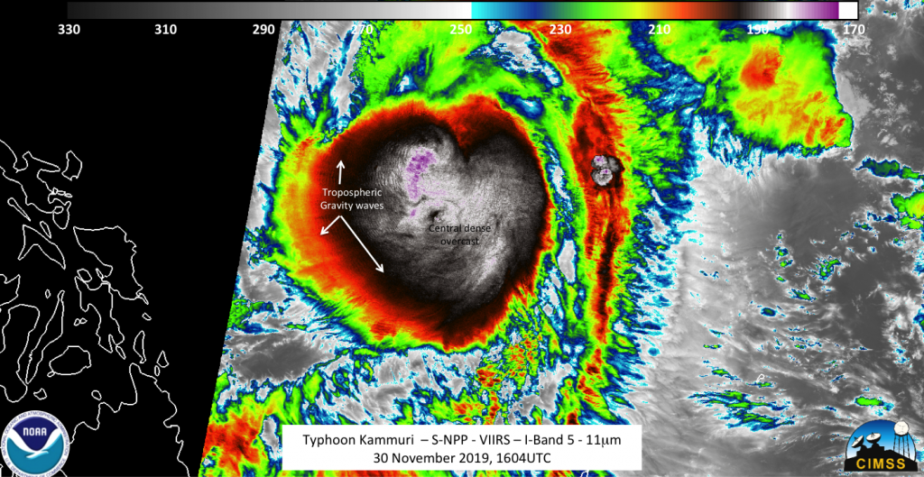
NASA-NOAA’s S-NPP satellite saw Typhoon Kammuri on Nov. 30 at 1:04 p.m. EST (1604 UTC) on the extreme western side of the pass for the satellite. Imagery continued to show a large central dense overcast (CDO) that would obscure the low-level circulation.
The CDO of a tropical cyclone is the large central area of thunderstorms surrounding its circulation center. It is caused by the formation of its eyewall. It can be round, angular, oval, or irregular.

Several prominent features in the CDO include tropospheric gravity waves along with multiple overshooting tops. In addition, while this normally would be in the “noisy” part of the scene for the Day Night Band on S-NPP, there was still enough signal from the airglow (the moon was at waxing crescent with 16% illumination) to see mesospheric gravity waves along with a single lone lightning streak within the CDO. Infrared data revealed temperatures of cloud tops were as cold as 119 Kelvin (minus 117.6 degrees Fahrenheit/minus 83.1 degrees Celsius).
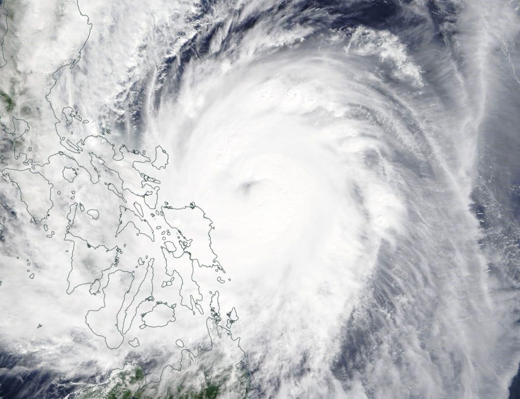
On Dec. 2, visible imagery from the Moderate Resolution Imaging Spectroradiometer or MODIS instrument aboard NASA’s Terra satellite showed that Kammuri’s eye continued to be covered by clouds. The western quadrant of Kammuri was already over the eastern central Philippines.
On Dec. 2, 2019 at 4 a.m. EST (0900 UTC) Typhoon Kammuri (Tisoy in the Philippines) was located near latitude 13.0 degrees north, and longitude 125.6 degrees east, about 285 nautical miles east-southeast of Manila, Philippines. Kammuri (Tisoy) is moving west and had maximum sustained winds 105 knots (121 mph/193 kph).
At 7 a.m. EST (1200), PAGASA raised 3 warning signals on Dec. 2. Tropical Cyclone Wind Signal number 3 is in effect for Luzon: Catanduanes, Camarines Sur, Albay, Sorsogon, southern portion of Camarines Norte, Masbate including Ticao and Burias Islands, Romblon, and southern portion of Quezon. In the central Philippines, it is in effect for the region of Visayas: Northern Samar, northern portion of Eastern Samar (Can-avid, Dolores, Maslog, Oras, Arteche, Jipapad, San Policarpio), and northern portion of Samar.
Tropical Cyclone Wind Signal number 2 is in effect in the northern Philippines for the region of Luzon: Metro Manila, Bulacan, Bataan, Tarlac, Pampanga, Nueva Ecija, southern Aurora, Cavite, Batangas, Laguna, Rizal, rest of Quezon including Polillo Islands, Oriental Mindoro, Occidental Mindoro, Marinduque, rest of Camarines Norte, Calamian Islands, southern portion of Zambales, In Visayas the signal covers: the rest of Eastern Samar, rest of Samar, Biliran, Aklan, Capiz, northern portion of Antique, northern portion of Iloilo, northern portion of Negros Occidental, Northern Cebu, and northern portion of Leyte.
Tropical Cyclone Wind Signal number 1 is in effect in the northern Philippines for the region of Luzon: Southern Isabela, Mountain Province, Ifugao, Benguet, Nueva Vizcaya, Ilocos Sur, La Union, Pangasinan, Quirino, rest of Aurora, and rest of Zambales. In Visayas: Rest of Antique, rest of Iloilo, Guimaras, rest of Negros Occidental, Metro Cebu, rest Leyte, and Southern Leyte. And in the region of Mindanao it is in effect for: Dinagat Islands and Siargao Island
Kammuri is moving in a westerly direction as it approaches the eastern Philippines. The Joint Typhoon Warning Center expects that the storm will strengthen slightly today, Dec. 2, but will then start to weaken. The typhoon is then expected to turn east-northeast as it passes through the Philippine archipelago, but will then veer southwest, weaken and dissipate.
For updated forecasts from PAGASA, visit: www.pagasa.dost.gov.ph
By William Straka III/ Rob Gutro
University of Wisconsin – Madison-SSEC-CIMSS
NASA’s Goddard Space Flight Center
