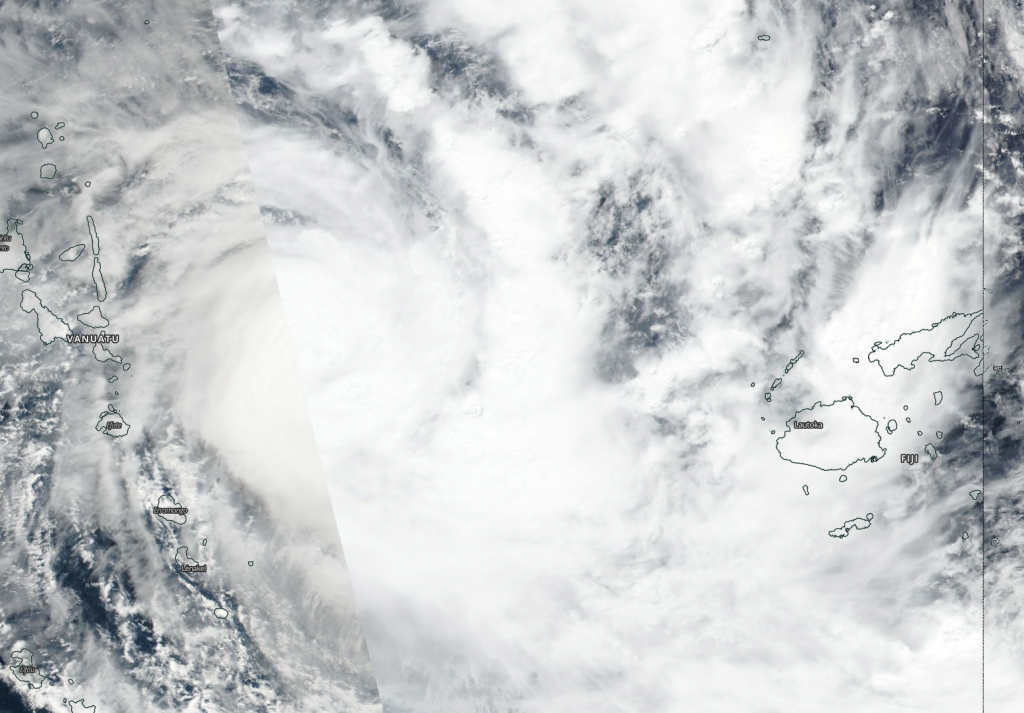
Apr. 07, 2020 – NASA Finds Tropical Cyclone Harold between Vanuatu and Fiji
Tropical Cyclone Harold brought heavy rains and hurricane-force winds to Vanuatu and was moving toward Fiji when NASA-NOAA’s Suomi NPP satellite provided forecasters with an image of the storm.

Visible imagery from NASA satellites help forecasters understand if a storm is organizing or weakening. The Visible Infrared Imaging Radiometer Suite (VIIRS) instrument aboard Suomi NPP provided a visible image of Harold on April 7, which showed the western quadrant of the storm east of Vanuatu while eastern quadrant was already affecting Fiji.
The shape of a tropical cyclone provides forecasters with an idea of its organization and strength, and NASA-NOAA’s Suomi NPP satellite showed powerful thunderstorms circling the low-level center of circulation with thick, fragmented bands of thunderstorms mostly on the eastern side of the storm. The eye was not visible on the Suomi NPP image. Forecasters at the Joint Typhoon Warning Center noted, “Animated enhanced infrared satellite imagery shows deep convection surrounding and obscuring the low level circulation center, possibly indicating an eye may be trying to form.”
Warnings are in effect for the Fiji group of islands. On April 7, warnings in Fiji included a hurricane warning for Kadavu and Ono-I-Lau. A storm warning is in effect for southern parts of Viti Levu [from Momi through to Pacific Harbour], Beqa, Vatulele, Matuku and Vatoa. A storm warning remains in force for Moala, Totoya, Vanuavatu and is now also in force for Yasawa and Mamanuca group, the rest of Viti Levu, Lomaiviti and the rest of Southern Lau group.
A gale warning remains in force for Lakeba and Cicia and the rest of the Lau Group, Vanua Levu, Taveuni and nearby smaller islands. A strong wind warning remains in force for the rest of Fiji.
At 10 a.m. EDT (1500 UTC) on April 7, Harold had maximum sustained winds near 110 knots (127 mph/204 kph) making it a Category 3 hurricane on the Saffir-Simpson Hurricane Wind Scale. Harold was centered near latitude 17.7 degrees south and longitude 174.9 degrees east, about 225 nautical miles west of Suva, Fiji. Harold was moving to the east-southeast at 14 knots (16 mph/26 kph).
The Joint Typhoon Warning Center or JTWC forecast said, “Through the next 24 hours, the intensity should remain around 105 to 110 knots (121 to 127 mph/194 to 204 kph), although the tropical cyclone may get stronger if an eye were to form.”
JTWC forecasts Harold to make a brief landfall over Fiji on April 7 around 8 p.m. EDT (April 8 at 0000 UTC) and move to the southeast near Tonga.
Tropical cyclones/hurricanes are the most powerful weather events on Earth. NASA’s expertise in space and scientific exploration contributes to essential services provided to the American people by other federal agencies, such as hurricane weather forecasting.
For forecast updates from the Fiji Meteorological Service: https://www.met.gov.fj/
