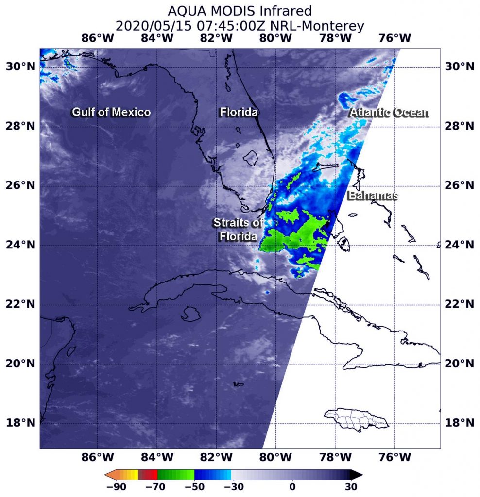
May 15, 2020 – NASA Analyzes Developing System 90L in Straits of Florida
A low-pressure area designated as System 90L appears to be developing in the Straits of Florida, located between Southern Florida and Cuba. NASA’s Aqua satellite measured cloud top temperatures within the developing system and found some stronger storms.

At 8:50 a.m. EDT on May 15, NOAA’s National Hurricane Center (NHC) issued a Special Tropical Weather Outlook issued to discuss the potential for tropical or subtropical development near the northwest Bahamas.
The Outlook stated, “A trough (elongated area) of low pressure located over the Straits of Florida continues to produce disorganized shower activity and gusty winds across the Florida Keys, portions of southeast Florida, and the northwestern Bahamas. Gradual development of this system is expected, and it will likely become a tropical or subtropical storm on Saturday [May 16] when it is located near the northwestern Bahamas. Later in the weekend and early next week, the system is expected to move generally northeastward over the western Atlantic (Ocean).”
NASA’s Aqua satellite provided information to NHC forecasters. One kind of data Aqua provides is infrared light to analyze the strength of storms by providing temperature information about the system’s clouds. The strongest thunderstorms that reach high into the atmosphere have the coldest cloud top temperatures.
On May 15 at 3:45 a.m., EDT (0745 UTC) the Moderate Resolution Imaging Spectroradiometer or MODIS instrument that flies aboard NASA’s Aqua satellite gathered infrared data on 90L. Strongest thunderstorms had cloud top temperatures as cold as minus 50 degrees Fahrenheit (minus 45.5 Celsius). As cloud tops continue to cool, they stretch higher into the troposphere. NASA research has shown that when cloud top temperatures drop to minus 70 degrees Fahrenheit (minus 56.6 degrees Celsius), storms have the ability to generate heavy rain.
The NHC Outlook stated, “Regardless of development, the disturbance will continue to bring heavy rainfall to portions of the Florida Keys, southeast Florida and the Bahamas through Saturday. Tropical storm-force wind gusts are also possible across portions of the Florida Keys, southeast Florida, and the Bahamas during the next day or so. In addition, hazardous marine conditions are expected along the Florida east coast and in the Bahamas where Gale Warnings are in effect. Dangerous surf conditions and rip currents are possible along portions of the southeast U.S. coast this weekend and early next week.”
The NHC said that the formation chance through 48 hours and out through 5 days is high.
Tropical cyclones and hurricanes are the most powerful weather events on Earth. NASA’s expertise in space and scientific exploration contributes to essential services provided to the American people by other federal agencies, such as hurricane weather forecasting.
For updated forecasts, visit: www.nhc.noaa.gov.
