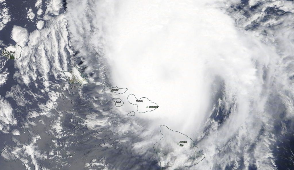
July 27, 2020 – NASA Sees Hurricane Douglas Brush Hawaii
Imagery from NASA’s Terra satellite was used to create an animation showing Douglas’ movement past the Hawaiian Islands.

Although the Hawaiian Islands missed a landfall from Hurricane Douglas, the storm was certainly close enough to bring strong surf, heavy rains and gusty winds to the islands. NASA’s Terra satellite imagery showed the storm’s track as it moved just north of the islands.
Visible imagery of Hurricane Douglas from July 25 to 26, taken from the Moderate Resolution Imaging Spectroradiometer or MODIS instrument aboard NASA’s Terra satellite was compiled and made into an animation using NASA’s Worldview application. The imagery showed Douglas’ center staying just off shore from the Hawaiian Islands.
NASA’s Earth Observing System Data and Information System (EOSDIS) Worldview application provides the capability to interactively browse over 700 global, full-resolution satellite imagery layers and then download the underlying data. Many of the available imagery layers are updated within three hours of observation, essentially showing the entire Earth as it looks “right now.”

Warnings in Effect on July 27
NOAA’s Central Pacific Hurricane Center (CPHC) posted several updates to the warnings on July 27. A Hurricane Warning is in effect for portions of the Papahanaumokuakea Marine National Monument from Nihoa to French Frigate Shoals. A Tropical Storm Warning is in effect for portions of the Papahanaumokuakea Marine National Monument from French Frigate Shoals to Maro Reef. A Hurricane Watch is in effect for portions of the Papahanaumokuakea Marine National Monument from French Frigate Shoals to Maro Reef, and a Tropical Storm Watch is in effect for portions of the Papahanaumokuakea Marine National Monument from Maro Reef to Lisianski.
Douglas’ Status on July 27, 2020
NOAA’s CPHC noted at 11 a.m. EDT (5 a.m. HST/1500 UTC), the center of Hurricane Douglas was located near latitude 22.9 degrees north and longitude 160.4 degrees west. Douglas is moving toward the west-northwest near 17 mph (28 kph), and this general motion will continue the next couple of days, with a slight turn toward the west. Maximum sustained winds are near 90 mph (150 kph) with higher gusts. The estimated minimum central pressure is 987 millibars.
In Hawaii, rainfall associated with Douglas is expected to affect portions of the main Hawaiian Islands today. Total rain accumulations of 3 to 6 inches with locally higher amounts are possible, with the greatest rainfall in elevated terrain on Kauai. Heavy rainfall will also affect portions of the Papahanaumokuakea Marine National Monument the next couple of days.
Douglas’ Forecast
NOAA’s CPHC noted, “Hurricane force winds are expected over portions of the Papahanaumokuakea Marine National Monument from Nihoa to French Frigate Shoals later today and tonight. Tropical storm conditions are expected from French Frigate Shoals to Maro Reef Tuesday and Tuesday night, with hurricane conditions possible.
Tropical storm conditions are possible from Maro Reef to Lisianski Tuesday night and Wednesday.
Large swells generated by Douglas will affect a large swath of the Papahanaumokuakea Marine National Monument the next couple of days. Weakening is forecast during the next couple of days.
For more than five decades, NASA has used the vantage point of space to understand and explore our home planet, improve lives and safeguard our future. NASA brings together technology, science, and unique global Earth observations to provide societal benefits and strengthen our nation. Advancing knowledge of our home planet contributes directly to America’s leadership in space and scientific exploration.
For updated forecasts, visit: www.nhc.noaa.gov
