July 27, 2020 (part 2) – NASA Tracks Hanna’s Soaking Path into Mexico
NASA’s Aqua satellite provided infrared data on Tropical Depression Hanna while imagery from NASA-NOAA’s Suomi NPP satellite was used to create an animation showing its movement from Texas to Mexico. Infrared data can reveal the location of powerful storms that generate heavy rainfall and Hanna drenched Texas upon landfall over the weekend of July 25-26.

Tracking Hanna’s Path to Mexico
Visible imagery of Hurricane Hanna from July 23 to 26, taken from the Visible Infrared Imaging Radiometer Suite (VIIRS) instrument aboard NASA-NOAA’s Suomi NPP satellite was compiled and made into an animation using NASA’s Worldview application. The imagery showed Hanna’s landfall in east central Texas and its track to the southwest into north central Mexico.
NASA’s Earth Observing System Data and Information System (EOSDIS) Worldview application provides the capability to interactively browse over 700 global, full-resolution satellite imagery layers and then download the underlying data. Many of the available imagery layers are updated within three hours of observation, essentially showing the entire Earth as it looks “right now.”

Hanna the Rainmaker Breaks Records
Hanna has been a big rainmaker. On July 25, the National Weather Service (NWS) at Corpus Christi, Texas reported 2.57 inches of rainfall from Hanna. Although not a record, it was a lot of rain.
On July 26, the NWS in Brownsville, Texas reported a new record for rainfall of 3.46 inches, breaking the old record of 2.74 inches that was set in 1890. Record rainfall was also recorded at McAllen Miller International Airport where the NWS reported 4.52 inches of rainfall on July 26, breaking the old record of 1.41 inches set in the year 2000.
An Infrared Look at Hanna’s Rainmaking Capability
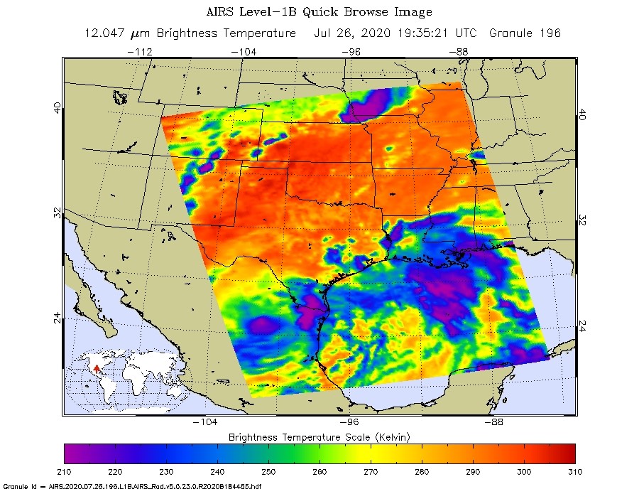
One of the ways NASA researches tropical cyclones is using infrared data that provides temperature information. The AIRS instrument aboard NASA’s Aqua satellite captured a look at those temperatures in Hanna and gave insight into the size of the storm and its rainfall potential.
Cloud top temperatures provide information to forecasters about where the strongest storms are located within a tropical cyclone. The stronger the storms, the higher they extend into the troposphere, and the colder the cloud top temperatures.
On July 26 at 3:35 p.m. EDT (1935 UTC) NASA’s Aqua satellite analyzed the storm using the Atmospheric Infrared Sounder or AIRS instrument. The strongest storms with the coldest cloud top temperatures were located over extreme south Texas and northeastern Mexico. AIRS found coldest cloud top temperatures as cold as or colder than minus 63 degrees Fahrenheit (minus 53 degrees Celsius). NASA research has shown that cloud top temperatures that cold indicate strong storms that have the capability to create heavy rain.
NASA provides the AIRS infrared data to forecasters at NOAA’s National Hurricane Center or NHC so they can incorporate it into their forecasting. The AIRS instrument is one of six instruments flying on board NASA’s Aqua satellite, launched on May 4, 2002.
More Heavy Rainfall from Hanna
The strong storms seen in infrared imagery continue to generate heavy rain and that rainfall is expected in parts of south Texas and in northern Mexico on July 27.
NHC forecasters said, “Hanna is expected to produce the following rain accumulations and flood threats through Monday: Far south Texas can expect an additional 1 to 2 inches. The northern Mexican states of Coahuila, Nuevo Leon, and Tamaulipas can expect 4 to 8 inches. Flash flooding and mudslides are possible across these Mexican states. In addition, the northern Mexican states of northern Zacatecas, northern San Luis Potosi, and eastern Durango can expect 1 to 2 inches.
Hanna’s Status on July 27, 2020
NOAA’s National Hurricane Center (NHC) reported at 5 a.m. EDT (0900 UTC) on July 26, the center of Tropical Depression Hanna was located near latitude 24.1 north, longitude 102.9 west. Hanna was centered about 65 miles (105 km) north of Fresnillo, Mexico. The estimated minimum central pressure was 1004 millibars. The depression was moving toward the west near 5 mph (7 kph) and this motion is expected to continue today. Maximum sustained winds were near 25 mph (35 kph) with higher gusts.
Hanna’s Forecast
NHC noted, “Ocean swells generated by Hanna will continue to affect much of the Texas and northeastern Mexico coasts early today. These swells may cause rip current conditions. Hanna will weaken into a remnant low today.”
For more than five decades, NASA has used the vantage point of space to understand and explore our home planet, improve lives and safeguard our future. NASA brings together technology, science, and unique global Earth observations to provide societal benefits and strengthen our nation. Advancing knowledge of our home planet contributes directly to America’s leadership in space and scientific exploration.
For updated forecasts, visit: www.nhc.noaa.gov
