July 30, 2020 – NASA Finds Post-Tropical Low Douglas Crossing a Line
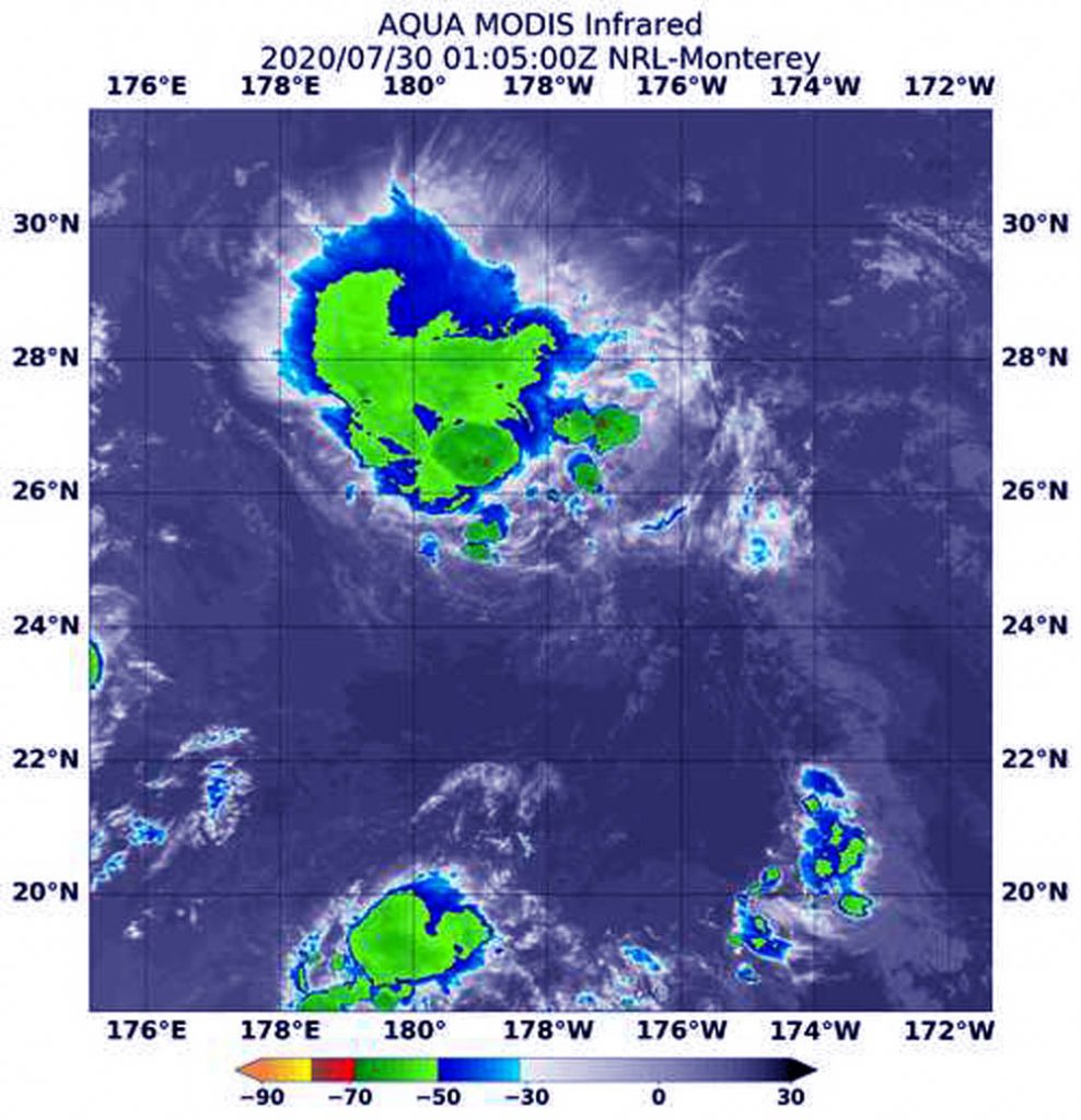
The strong wind shear that weakened Douglas to a tropical storm early on July 29 has further weakened it to a post-tropical low-pressure area. NASA’s Aqua satellite provided an infrared view of those remnants, headed across the International Date Line in the Pacific Ocean.

NASA’s Aqua Satellite Shows a Post-tropical System
NASA’s Aqua satellite uses infrared light to analyze the strength of storms by providing temperature information about the system’s clouds. The strongest thunderstorms that reach high into the atmosphere have the coldest cloud top temperatures.
On July 30 at 0105 UTC (July 29 at 9:05 p.m. EDT), the Moderate Resolution Imaging Spectroradiometer or MODIS instrument that flies aboard NASA’s Aqua satellite gathered infrared data on Douglas that confirmed wind shear had reduced the storm to a post-tropical low pressure area. The wind shear pushed the coldest cloud tops northeast of the center. Those storms had cloud top temperatures as cold as minus 50 degrees Fahrenheit (minus 45.5 Celsius).
What is a Post-tropical Cyclone?
NOAA’s National Hurricane Center defines a post-tropical cyclone as a former tropical cyclone. This generic term describes a cyclone that no longer possesses sufficient tropical characteristics to be considered a tropical cyclone. Post-tropical cyclones can continue carrying heavy rains and high winds. Note that former tropical cyclones that have become fully extratropical… as well as remnant lows…are two classes of post-tropical cyclones.
Douglas Ready to Cross a Line
NOAA’s Central Pacific Hurricane Center (CPHC) issued the final advisory on Douglas on July 29 at 11 a.m. EDT (5 a.m. HST/1500 UTC). Douglas had degenerated into a post-tropical low-pressure area about 1,135 miles (1,830 km) west-northwest of Honolulu, Hawaii. It was centered near latitude 24.7 degrees north and longitude 175.4 degrees west. The post-tropical cyclone is moving toward the west near 23 mph (37 kph). Maximum sustained winds are near 35 mph (55 kph) with higher gusts.
Douglas’ remnants were expected to cross the International Date Line early on July 30, and it is expected to dissipate shortly after the crossing.
Established in 1884, the International Date Line passes through the mid-Pacific Ocean and generally follows a 180 degrees longitude north-south line on the Earth. East of the Date Line lies the central Pacific Ocean. West of the dateline is the western Pacific Ocean.
NASA Researches Tropical Cyclones
Hurricanes/tropical cyclones are the most powerful weather events on Earth. NASA’s expertise in space and scientific exploration contributes to essential services provided to the American people by other federal agencies, such as hurricane weather forecasting.
For more than five decades, NASA has used the vantage point of space to understand and explore our home planet, improve lives and safeguard our future. NASA brings together technology, science, and unique global Earth observations to provide societal benefits and strengthen our nation. Advancing knowledge of our home planet contributes directly to America’s leadership in space and scientific exploration.
For updated forecasts. visit: www.nhc.noaa.gov
