Aug. 28, 2020 – NASA Sees Wind Shear Still Battering Tropical Storm Iselle
NASA infrared imagery shows wind shear continued to batter Tropical Storm Iselle in the Eastern Pacific Ocean for the second day.

NASA’s Infrared Data Finds Push of Winds
Tropical cyclones are made up of hundreds of thunderstorms, and infrared data can show where the strongest storms are located. That is because infrared data provides temperature information, and the strongest thunderstorms that reach highest into the atmosphere have the coldest cloud top temperatures.
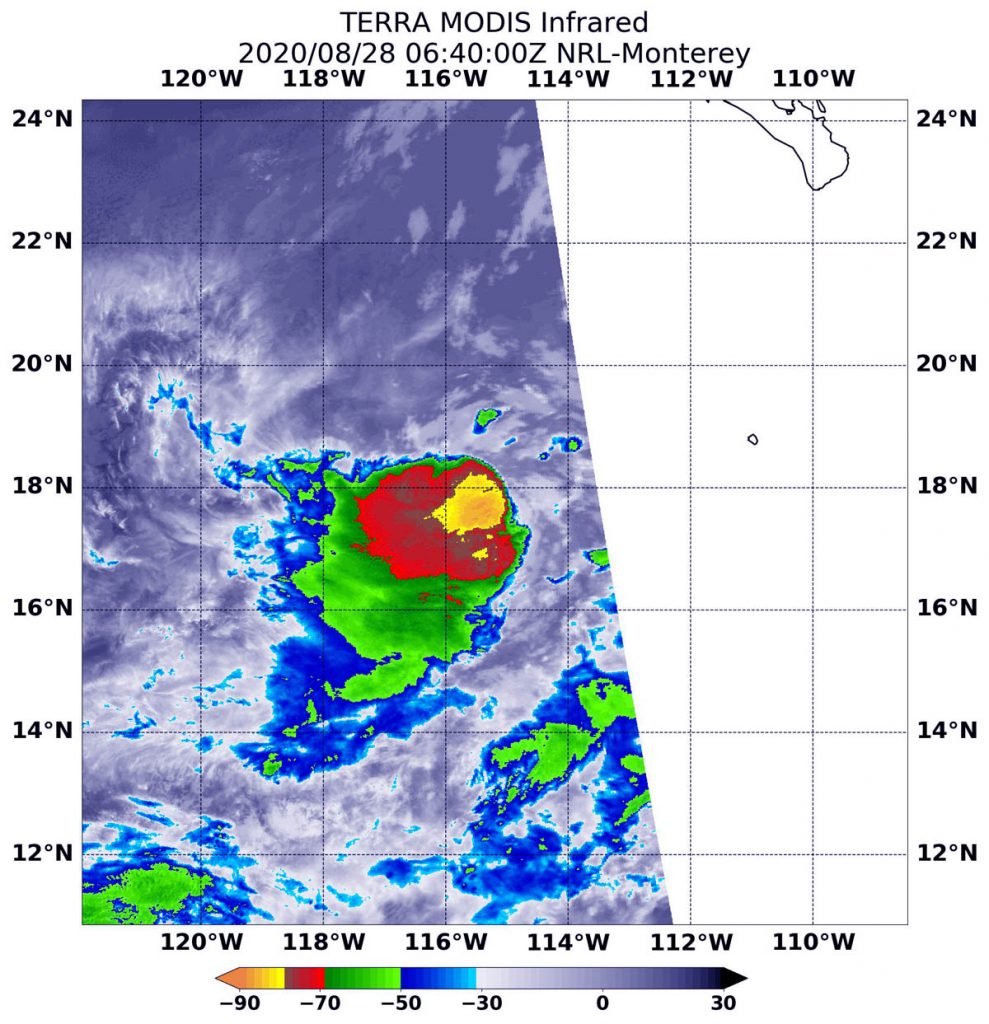
On Aug. 28 at 2:40 a.m. EDT (0640 UTC), the Moderate Resolution Imaging Spectroradiometer (MODIS) instrument aboard NASA’s Terra satellite captured an infrared image of cloud top temperatures in Iselle. Iselle continues to produce deep convection and strong thunderstorms near the center and on its west side. The data revealed the most powerful thunderstorms minus 80 degrees Fahrenheit (minus 62.2 degrees Celsius) near the center. Wind shear was pushing the rest of the storms to the west. Some had cloud top temperatures as cold as minus 70 degrees Fahrenheit (minus 56.6. degrees Celsius) and were dropping large amounts of rain. This asymmetric cloud pattern is due to a moderate amount of easterly wind shear.
National Hurricane Center (NHC) intensity forecast follows the trend of the models, and predicts Iselle to weaken to a tropical depression in a couple of days and to a remnant low shortly thereafter.
What Wind Shear Does to a Tropical Cyclone
In general, wind shear is a measure of how the speed and direction of winds change with altitude. Tropical cyclones are like rotating cylinders of winds. Each level needs to be stacked on top each other vertically in order for the storm to maintain strength or intensify. Wind shear occurs when winds at different levels of the atmosphere push against the rotating cylinder of winds, weakening the rotation by pushing it apart at different levels.
Iselle’s Status on Aug. 28, 2020
At 5 a.m. EDT (0900 UTC), the center of Tropical Storm Iselle was located near latitude 17.9 degrees north and longitude 115.0 degrees west. That is about 480 miles (770 km) southwest of the southern tip of Baja California, Mexico. Iselle is moving toward the northeast near 5 mph (7 kph) and this general motion is expected to continue through tonight. Maximum sustained winds have increased to near 60 mph (95 kph) with higher gusts. The estimated minimum central pressure is 997 millibars.
Forecast from NHC
A northward and then northwestward motion is expected during the weekend. Little change in strength is expected today, but a gradual weakening trend should begin tonight.
NASA Researches Earth from Space
For more than five decades, NASA has used the vantage point of space to understand and explore our home planet, improve lives and safeguard our future. NASA brings together technology, science, and unique global Earth observations to provide societal benefits and strengthen our nation. Advancing knowledge of our home planet contributes directly to America’s leadership in space and scientific exploration.
For updated forecasts, visit: www.nhc.noaa.gov
