Sep. 02, 2020 – NASA Finds New Tropical Storm Nana Strengthening in the Caribbean
The storm was a potential tropical depression on Sept. 1, but by Sept. 2, the area of low pressure in the Caribbean Sea strengthened into a tropical storm and was named Nana.
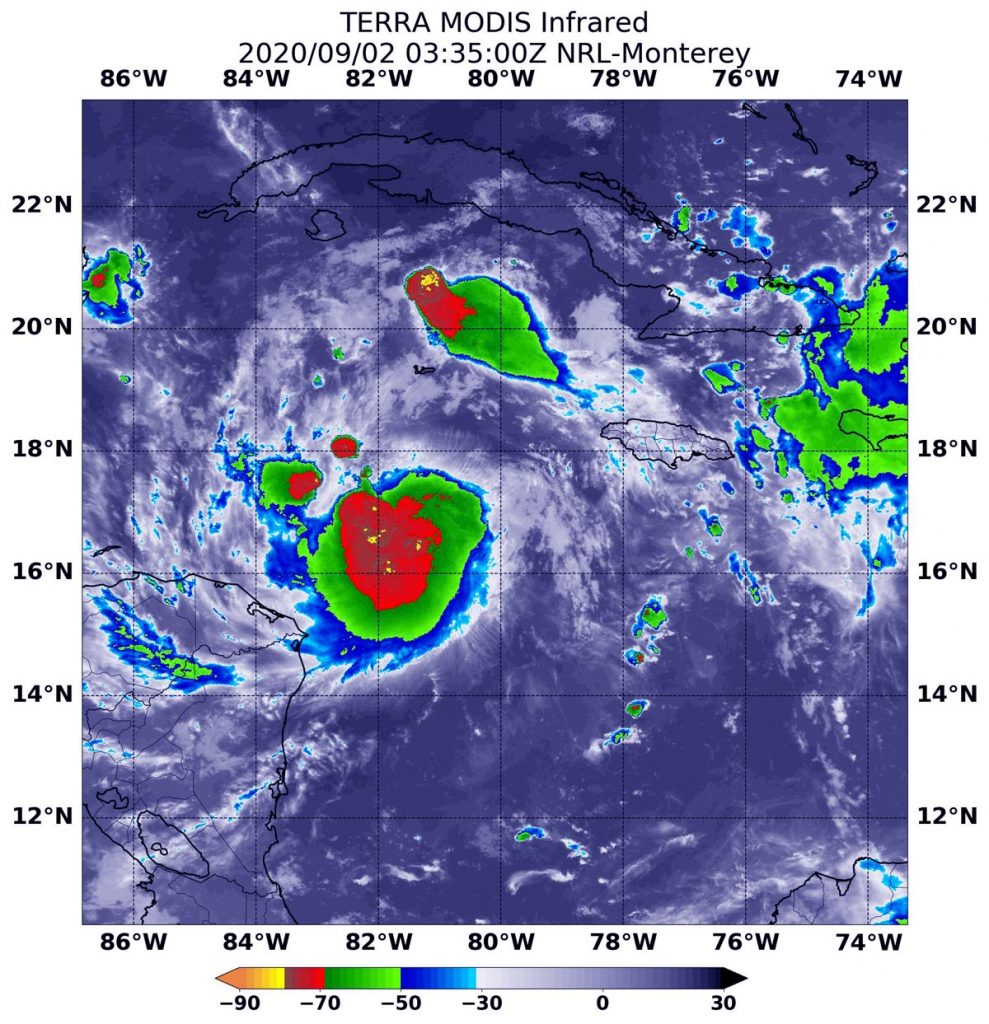
NASA’s Terra satellite provided forecasters with a look at the strength of the thunderstorms that make up Nana by analyzing cloud top temperatures.

Potential Tropical Depression 16 developed into a tropical storm by 12:05 p.m. EDT on Sept. 1, south of Jamaica. Tropical Storm Nana is the 14th named tropical storm of the 2020 Atlantic hurricane season.
Warnings and Watches Now in Effect
NOAA’s National Hurricane Center (NHC) posted watches and warnings on Sept. 2 for areas in Central America, as Nana is forecast to move on a westerly path through the Caribbean Sea.
A Hurricane Watch is in effect for the entire coast of Belize. A Tropical Storm Warning is in effect for Yucatan, Mexico from Puerto Costa Maya to Chetumal, Mexico and for the entire coast of Belize.
A Tropical Storm Watch is in effect for the northern coast of Honduras from Punta Patuca westward to the Guatemala border, for Roatan Island and the Bay Islands of Honduras and for the Caribbean Sea coast of Guatemala.
Infrared Data Reveals Nana Strengthening
On Sept. 1 at 11:35 p.m. EDT (Sept. 2 at 335 UTC), the Moderate Resolution Imaging Spectroradiometer or MODIS instrument aboard NASA’s Terra satellite gathered temperature information about Tropical Storm Nana’s cloud tops. Strongest storms were around the center of the storm, where temperatures were as cold as or colder than minus 80 degrees (minus 62.2 degrees Fahrenheit). That area was surrounded by large area of slightly less powerful storms where cloud top temperatures were as cold as or colder than minus 70 degrees Fahrenheit (minus 56.6 Celsius).
“Nana’s Central Dense Overcast has become a little better defined, with cloud tops to minus 80 degrees Celsius [minus 112 degrees Fahrenheit] or colder. Upper-level outflow continues to be somewhat inhibited over the northern portion of the circulation. SFMR-observed surface winds and adjusted flight-level winds from an Air Force Hurricane Hunter aircraft indicated an intensity of 50 knots. Although northerly [wind] shear is likely to limit intensification, the environment is conducive enough for Nana to strengthen into a hurricane later today,” Dr. Richard Pasch wrote in the 5 a.m. EDT Nana Discussion. Pasch is a senior hurricane specialist at NOAA’s National Hurricane Center (NHC) in Miami, Florida.
Nana’s Status on Sept. 2
At 8 a.m. EDT (1200 UTC) on Sept. 2, the center of Tropical Storm Nana was located near latitude 17.1 degrees north and longitude 83.7 degrees west. It was centered about 150 miles (240 km) northeast of Limon, Honduras and 305 miles (490 km) east of Belize City, Belize.
Nana was moving toward the west near 18 mph (30 kph), and this general motion with some decrease in forward speed is expected today. Maximum sustained winds were near 60 mph (95 kph) with higher gusts. The minimum central pressure estimated from a NOAA Hurricane Hunter aircraft observations is 996 millibars.
Nana Forecast Toward Belize
The NHC forecast expects a westward or west-southwestward motion tonight and Thursday. Strengthening is expected, and Nana is forecast to become a hurricane later today or tonight before it reaches the coast of Belize. On the forecast track, Nana will be moving near but north of the coast of Honduras today and likely be approaching the coast of Belize tonight and early Thursday.
Tropical cyclones/hurricanes are the most powerful weather events on Earth. NASA’s expertise in space and scientific exploration contributes to essential services provided to the American people by other federal agencies, such as hurricane weather forecasting.
For updated forecasts, visit: www.nhc.noaa.gov
