Sep. 16, 2020 – NASA Observes Hurricane Sally Making Early Morning Landfall in Alabama
NASA’s Aqua satellite and the NASA-NOAA Suomi NPP satellite provided views of the strength, extent and rainfall potential as Hurricane Sally was making landfall during the morning hours of Sept. 16.
Watches and Warnings
NOAA’s National Hurricane Center has many warnings and watches in place today, Sept. 16. A Storm Surge Warning is in effect from Dauphin Island, Alabama to the Walton/Bay County Line, Florida. A Hurricane Warning is in effect for the Mississippi/Alabama border to the Okaloosa/Walton County line, Florida.
A Tropical Storm Warning is in effect for east of the Okaloosa/Walton County line, Florida to Indian Pass, Florida and from the Mississippi/Alabama border to the Mouth of the Pearl River.

NASA’s Infrared Data Reveals Heavy Rainmakers
Tropical cyclones and hurricanes are made up of hundreds of thunderstorms, and infrared data can show where the strongest storms are located. That is because infrared data provides temperature information, and the strongest thunderstorms that reach highest into the atmosphere have the coldest cloud top temperatures.
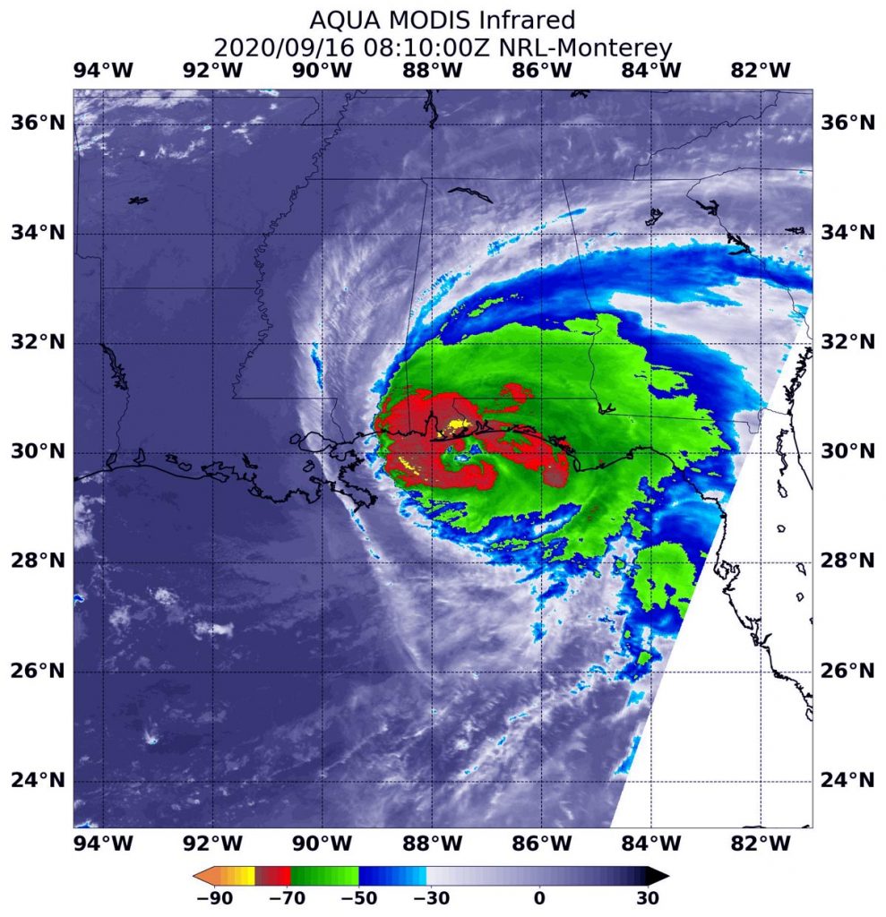
On Sept. 16 at 4:10 a.m. EDT (0810 UTC) the Moderate Resolution Imaging Spectroradiometer or MODIS instrument that flies aboard NASA’s Aqua satellite used infrared light to analyze the strength of storms within Sally. MODIS found the most powerful thunderstorms were north of the eye where cloud top temperatures were as cold as minus 80 degrees Fahrenheit (minus 62.2 Celsius).
Strong storms with cloud top temperatures as cold as minus 70 degrees Fahrenheit (minus 56.6. degrees Celsius) circled the most powerful storms. NASA research has found that cloud top temperatures that cold indicate strong storms with the potential to generate heavy rainfall.
NASA’s Night-Time View of Sally’s Landfall Approach
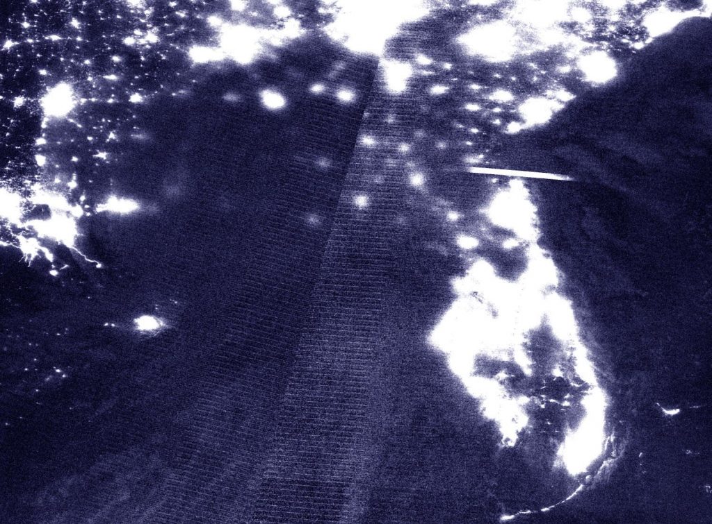
On Sept. 16 at 4:15 a.m. EDT (0815 UTC), the Visible Infrared Imaging Radiometer Suite (VIIRS) instrument aboard NOAA-NASA’s Suomi NPP satellite captured an early morning image of Hurricane Sally approaching landfall near Gulf Shores, Alabama as a Category 2 Hurricane. This nighttime image shows the extent of Sally’s clouds blotting out the city lights from southern Mississippi to the northwestern coast and panhandle of Florida.

Sally’s Official Landfall
NOAA’s National Hurricane Center reported that Hurricane Sally made landfall at 5:45 a.m. EDT (4:45 a.m. EDT/0945) near Gulf Shores, Alabama as a as a Category 2 hurricane, with maximum sustained winds of 105 mph (165 kph) and a minimum central pressure of 965 millibars.
Sally’s Status at 8 a.m. EDT on Sept. 16
The NHC noted at 8 a.m. EDT (1200 UTC), the center of the eye of Hurricane Sally was located by NOAA Doppler weather radars near latitude 30.4 degrees north and longitude 87.6 degrees west. Sally’s eye was just 15 miles (25 km) north-northeast of Gulf Shores, Alabama and 25 miles (40 km) west-southwest of Pensacola, Florida.
Sally is moving toward the north-northeast near 3 mph (6 kph). A north-northeastward to northeastward motion at a slightly faster forward speed is expected later today and tonight, followed by a faster northeastward motion on Thursday. Doppler weather radar data indicate that the maximum sustained winds are near 100 mph (155 kph) with higher gusts.
Hurricane-force winds extend outward up to 40 miles (65 km) from the center and tropical-storm-force winds extend outward up to 125 miles (205 km). A sustained wind of 74 mph (119 kph) and a gust to 92 mph (148 kph) were recently reported at the Pensacola Naval Air Station in Pensacola, Florida. The estimated minimum central pressure based on surface observations is 967 millibars.
NHC Key Messages, Historic and catastrophic flooding is unfolding
The National Hurricane Center issued Key Messages about Rainfall, Wind, Tornadoes and Surf:
RAINFALL: Through this afternoon, Sally will produce additional rainfall totals of 8 to 12 inches with localized higher amounts possible along and just inland of the central Gulf Coast from west of Tallahassee, Florida to Mobile Bay, Alabama. Storm totals of 10 to 20 inches to isolated amounts of 35 inches is expected. In addition, this rainfall will lead to widespread moderate to major river flooding.
Sally is forecast to turn northeastward after making landfall today and move across the Southeast through Friday, producing the following rainfall totals:
Southern and central Alabama to central Georgia: 4 to 8 inches, with isolated maximum amounts of 12 inches. Significant flash and urban flooding is likely, as well as widespread minor to moderate flooding on some rivers.
Western South Carolina into western and central North Carolina: 4 to 6 inches, with isolated maximum amounts of 9 inches. Widespread flash and urban flooding is possible, as well as minor to moderate river flooding.
Southeast Virginia: 2 to 5 inches, with isolated maximum amounts of 7 inches. Scattered flash and urban flooding is possible, as well as scattered minor river flooding.
STORM SURGE: The combination of a dangerous storm surge and the tide will cause normally dry areas near the coast to be flooded by rising waters moving inland from the shoreline. The water could reach the following heights above ground somewhere in the indicated areas if the peak surge occurs at the time of high tide.
- AL/FL Border to Okaloosa/Walton County Line, FL including Pensacola Bay and Choctawhatchee Bay, 4-7 ft
- Okaloosa/Walton County Line, FL to Walton Bay County Line, FL, 2-4 ft
- Dauphin Island, AL to AL/FL Border including Bon Secour Bay, 2-4 ft
- Walton Bay County Line, FL to Chassahowitzka, FL including Saint Andrew Bay, 1-3 ft
The deepest water will occur along the immediate coast in areas of onshore winds, where the surge will be accompanied by large and damaging waves. Surge-related flooding depends on the relative timing of the surge and the tidal cycle, and can vary greatly over short distances.
WIND: Hurricane conditions are spreading onshore within the hurricane warning area in Florida and Alabama. Tropical storm conditions will continue in portions of the warning areas through tonight.
TORNADOES: A few tornadoes may occur today and tonight across portions of the Florida Panhandle, southern Alabama, and southwestern Georgia.
SURF: Swells from Sally will continue to affect the coast from the Florida Big Bend westward to southeastern Louisiana during the next couple of days. These swells are likely to cause life-threatening surf and rip current conditions.
Sally’s Forecast from NHC
Weakening is expected as the center moves inland today and tonight. On the forecast track, the center of Sally will move across the extreme western Florida panhandle and southeastern Alabama through early Thursday, and move over central Georgia Thursday afternoon through Thursday night.
About NASA’s EOSDIS Worldview
NASA’s Earth Observing System Data and Information System (EOSDIS) Worldview application provides the capability to interactively browse over 700 global, full-resolution satellite imagery layers and then download the underlying data. Many of the available imagery layers are updated within three hours of observation, essentially showing the entire Earth as it looks “right now.”
NASA Researches Earth from Space
For more than five decades, NASA has used the vantage point of space to understand and explore our home planet, improve lives and safeguard our future. NASA brings together technology, science, and unique global Earth observations to provide societal benefits and strengthen our nation. Advancing knowledge of our home planet contributes directly to America’s leadership in space and scientific exploration.
For updated forecasts, visit: www.nhc.noaa.gov
