Sep. 24, 2020 – NASA Estimating Beta’s Rains Moving into the Tennessee Valley
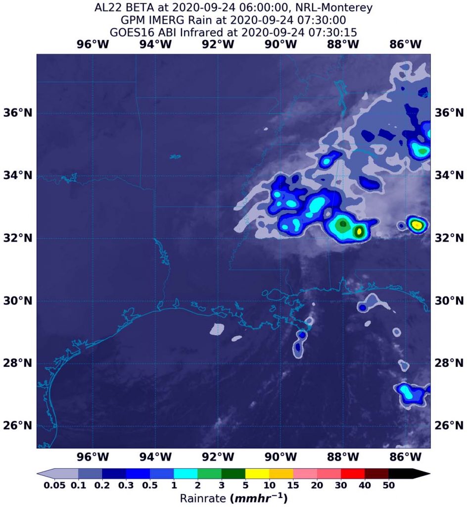
Using a NASA satellite rainfall product that incorporates data from satellites and observations, NASA estimated Post-tropical Cyclone Beta’s rainfall rates as it moved over Mississippi, Alabama and Tennessee. Beta continues a steady northeast track into Mississippi, bringing heavy rainfall across Mississippi into the Tennessee Valley.

Beta’s Status on Sept. 24
NOAA’s National Weather Service Weather Prediction Center (WPC) in College Park, Md. noted that at 5 a.m. EDT (0900 UTC) the center of Post-Tropical Cyclone Beta was located near latitude 31.9 degrees north and longitude 91.0 degrees west. The post-tropical cyclone is moving toward the northeast near 12 mph (19 kph). Maximum sustained winds are near 30 mph (45 kph) with higher gusts.
Estimating Beta’s Rainfall Rates from Space
NASA’s Integrated Multi-satellitE Retrievals for GPM or IMERG, which is a NASA satellite rainfall product, estimated on Sept. 24 at 3:30 a.m. EDT (0730 UTC), Beta was generating as much as 10 to 15 mm (0.40 to 0.60 inches) of rain per hour over Alabama. Lighter rainfall rates were occurring over Mississippi and Tennessee at the time of the image. Rainfall throughout most of the storm was estimated as falling at a rate between 0.2 and 1 mm (0.007 to 0.4 inches) per hour.
At the U.S. Naval Laboratory in Washington, D.C., the IMERG rainfall data was overlaid on infrared imagery from NOAA’s GOES-16 satellite to provide a full extent of the storm.
Watches and Warnings
On Sept. 24, Flash Flood Watches were in effect from southwestern Mississippi to parts of northern Alabama, and southern Middle Tennessee.
NOAA’s WPC said, “Rainfall totals of 2 to 4 inches are expected through early Friday from central to northern Mississippi, across the Middle Tennessee Valley and into the Southern Appalachians. Isolated flash and urban flooding is possible, as well as isolated minor river flooding on smaller rivers. An isolated tornado or two are possible this afternoon across Southern Alabama.”
Beta’s Forecast
Beta is expected to continue moving in a northeasterly direction for the next day and a half. Some weakening is forecast for the next 36 hour before weakening into a frontal system.
What Does IMERG Do?
This near-real time rainfall estimate comes from the NASA’s IMERG, which combines observations from a fleet of satellites, in near-real time, to provide near-global estimates of precipitation every 30 minutes. By combining NASA precipitation estimates with other data sources, we can gain a greater understanding of major storms that affect our planet.
What the IMERG does is “morph” high-quality satellite observations along the direction of the steering winds to deliver information about rain at times and places where such satellite overflights did not occur. Information morphing is particularly important over the majority of the world’s surface that lacks ground-radar coverage. Basically, IMERG fills in the blanks between weather observation stations.
NASA Researches Tropical Cyclones
Hurricanes/tropical cyclones are the most powerful weather events on Earth. NASA’s expertise in space and scientific exploration contributes to essential services provided to the American people by other federal agencies, such as hurricane weather forecasting.
For more than five decades, NASA has used the vantage point of space to understand and explore our home planet, improve lives and safeguard our future. NASA brings together technology, science, and unique global Earth observations to provide societal benefits and strengthen our nation. Advancing knowledge of our home planet contributes directly to America’s leadership in space and scientific exploration.
For more information about NASA’s IMERG, visit: https://pmm.nasa.gov/gpm/imerg-global-image
For forecast updates on hurricanes, visit: www.hurricanes.gov
By Rob Gutro
NASA’s Goddard Space Flight Center
