Feb. 07, 2020 -NASA Analyzes Tropical Cyclone Damien’s Water Vapor Concentration
When NASA’s Aqua satellite passed over the Southern Indian Ocean on Feb. 7, it gathered water vapor data that provided information about the intensity of Tropical Cyclone Damien.

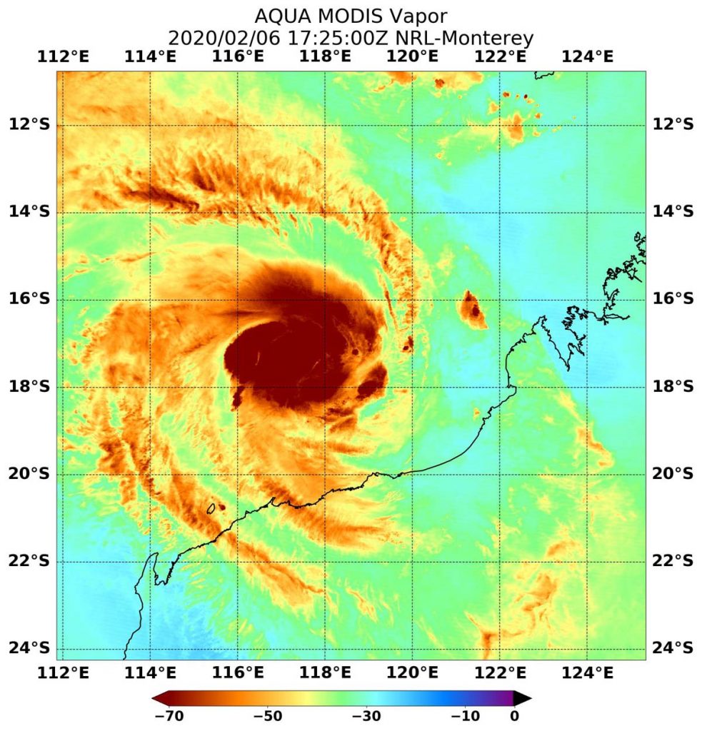
On Feb. 7 at 12:25 a.m. EST (1725 UTC), NASA’s Aqua satellite passed over Tropical Cyclone Damien, located in the Southern Indian Ocean and off Australia’s Pilbara coast. Aqua found highest concentrations of water vapor (brown) and coldest cloud top temperatures were around the center. Credits: NASA/NRLThe Australian Bureau of Meteorology (ABM) issued warnings and watches as Tropical Cyclone Damien moves toward the Pilbara Coast of Western Australia.
On Friday, February 7 at 11:46 pm WST (10:46 a.m. EST), the Warning Zone extends from Pardoo to Onslow, including Port Hedland, Karratha, Dampier, Pannawonica and Barrow Island and extending to adjacent inland parts to include Marble Bar, Tom Price and Paraburdoo. The Watch Zone includes inland central Pilbara including Nullagine, Newman and Mt Augustus.
ABM forecasters expect Severe Tropical Cyclone Damien to cause gales on the Pilbara coast from early Saturday morning. Very Destructive winds, very heavy rainfall and a storm surge are expected as Damien crosses the coast during Saturday, Feb. 8.
NASA’s Aqua satellite passed over Tropical Cyclone Damien on Feb. 7 at 12:25 a.m. EST (1725 UTC) and the Moderate Resolution Imaging Spectroradiometer or MODIS instrument gathered water vapor content and temperature information. The MODIS image showed highest concentrations of water vapor and coldest cloud top temperatures were around the center of circulation.
MODIS data also showed coldest cloud top temperatures were as cold as or colder than minus 70 degrees Fahrenheit (minus 56.6 degrees Celsius) in those storms. Storms with cloud top temperatures that cold have the capability to produce heavy rainfall.
Water vapor analysis of tropical cyclones tells forecasters how much potential a storm has to develop. Water vapor releases latent heat as it condenses into liquid. That liquid becomes clouds and thunderstorms that make up a tropical cyclone. Temperature is important when trying to understand how strong storms can be. The higher the cloud tops, the colder and the stronger the storms.
On February 7 at 11:46 pm WST (10:46 a.m. EST), ABM reported that Damien was a Category 3 storm with maximum sustained winds near the center of 140 kilometers (87 miles) per hour with higher wind gusts. Damien was located near latitude 18.9 degrees south and longitude 16.7 degrees east, about 205 kilometers (127 miles) north of Karratha and 255 kilometers (158 miles) northwest of Port Hedland. Damien is moving to the south-southwest.
Forecasters at the ABM reported on Feb. 7, “Severe Tropical Cyclone Damien (Category 3) is expected to intensify as it moves towards the Pilbara coast. Damien is likely to cross the coast between Whim Creek and Mardie during Saturday as a Category 4 system. Later on Saturday or Sunday, Damien will move inland and weaken.”
For the Australian Bureau of Meteorology Weather video update on Feb. 7, visit: https://youtu.be/TgO9v0mYiCM
NASA’s Aqua satellite is one in a fleet of NASA satellites that provide data for hurricane research.
Tropical cyclones/hurricanes are the most powerful weather events on Earth. NASA’s expertise in space and scientific exploration contributes to essential services provided to the American people by other federal agencies, such as hurricane weather forecasting.
For updated forecasts from the ABM, visit: http://www.bom.gov.au/cyclone/index.shtml
