Veronica (Southern Indian Ocean)

March 22, 2019 – Powerful Tropical Cyclone Veronica Eyes Australia’s Pilbara Coast
NASA-NOAA’s Suomi NPP satellite passed over the Southern Indian Ocean and captured a visible image of Severe Tropical Cyclone Veronica on March 22 as it moved toward the Pilbara Coast of Western Australia. Veronica was illuminated by the full moon. Credit: NASA/NOAA/UWM-CIMSS, William Straka III

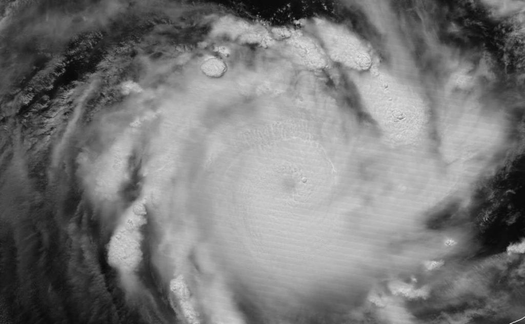
Tropical Cyclone Veronica continued to move toward Australia’s Pilbara Coast in Western Australia. NASA-NOAA’s Suomi NPP satellite provided visible and infrared images of the storm that indicated heavy rainfall.

The Australian Bureau of Meteorology, or ABM updated warnings on March 22. The Warning zone extends from Wallal Downs to Mardie including Port Hedland, Karratha and Barrow Island.

The Watch zone extends to the inland Pilbara to include Pannawonica, Marble Bar and Nullagine.

NASA-NOAA's Suomi NPP satellite passed over the Southern Indian Ocean and captured a visible image of Severe Tropical Cyclone Veronica on March 22 as it moved toward the Pilbara Coast of Western Australia. Veronica was illuminated by the full moon. Credit: NASA/NOAA/UWM-CIMSS, William Straka III
NASA-NOAA’s Suomi NPP satellite passed over the Southern Indian Ocean and captured a visible image of Severe Tropical Cyclone Veronica on March 22 as it moved toward the Pilbara Coast of Western Australia. The infrared channel on VIIRS showed large amounts of tropospheric gravity waves and overshooting [cloud] tops associated with the intense convection. Credit: NASA/NOAA/UWM-CIMSS, William Straka III
Suomi NPP passed over Savannah on March 22 and the Visible Infrared Imaging Radiometer Suite (VIIRS) instrument provided visible and infrared images of the storm. William Straka III, who created some of the images noted “As you would expect, the infrared channel on VIIRS showed large amounts of tropospheric gravity waves and overshooting [cloud] tops associated with the intense convection. In another image Veronica was illuminated by the full moon.”

Shortly after the Suomi NPP satellite passed over the storm, the GCOM-W1 satellite also flew over Severe Tropical Cyclone Veronica. “The Advanced Microwave Scanning Radiometer or AMSR2 instrument aboard GCOM-W1 showed a completely enclosed eye as well as the convection around the circulation,” Straka said. The microwave instruments provide critical information that is not seen by the infrared or visible imagery for forecasters.

As of 9:02 a.m. EDT (9:02 p.m. AWST local time) on March 22, Severe Tropical Cyclone Veronica was a category 4 storm on the Australian scale. Veronica had sustained winds of 175 kilometers per hour. It was centered near 17.9 degrees south latitude and 116.9 degrees east longitude about 315 kilometers north of Karratha.

ABM noted “Severe Tropical Cyclone Veronica, a Category 4 system, is moving slowly southwards towards the Pilbara coast. During Saturday it is expected to take a more southeast track and reach the coast late Saturday or Sunday. A severe coastal impact is likely.”

For updated forecasts, visit ABM: http://www.bom.gov.au/

By Rob Gutro
NASA’s Goddard Space Flight Center, Greenbelt, Md.

Trevor (Southwestern Pacific Ocean)

March 22, 2019 – Tropical Cyclone Trevor Fills Australia’s Gulf of Carpentaria in NASA Image
On March 22, 2019, the MODIS instrument aboard NASA's Aqua satellite provided a visible image of Tropical Cyclone Trevor, filling up the Gulf of Carpentaria. Credit: NASA Worldview, Earth Observing System Data and Information System (EOSDIS)
On March 22, 2019, the MODIS instrument aboard NASA’s Aqua satellite provided a visible image of Tropical Cyclone Trevor, filling up the Gulf of Carpentaria. Credit: NASA Worldview, Earth Observing System Data and Information System (EOSDIS)

Visible imagery from NASA’s Aqua satellite showed Tropical Cyclone Trevor filling up Australia’s Gulf of Carpentaria.

The Gulf of Carpentaria is a large, shallow sea. It is surrounded on three sides by northern Australia and bounded by the Arafura Sea to the north.

Trevor had crossed the Cape York Peninsula on March 21 and moved into the Gulf. On On March 22 the Moderate Resolution Imaging Spectroradiometer or MODIS instrument aboard NASA’s Aqua satellite provided a visible image of Trevor. Satellite imagery revealed that Trevor’s clouds had filled up the Gulf. It showed that bands of thunderstorms circled more tightly around the center of circulation than the previous day.

The Australian Bureau of Meteorology or ABM updated warnings and watches on March 22, 2019. The Warning Zone includes Alyangula in the Northern Territory to Burketown in Queensland, and inland parts of the eastern Carpentaria District and the northwest Gulf Country, including Groote Eylandt, Mornington Island, Borroloola, Robinson River, Wollogorang, McArthur River, Cape Crawford, Creswell Downs, Brunette Downs and Doomadgee. The Watch Zone includes inland parts of the northwest Gulf Country in Queensland and the western Carpentaria and central Barkly Districts in the Northern Territory.

At 8 a.m. EDT (9:30 p.m. Australian Central Standard Time or ACST) on March 22, 2019, maximum sustained winds near Trevor’s center were near 90 miles (150 kilometers) per hour. Trevor was centered near 15.0 degrees south latitude and 138.9 degrees east longitude. That’s about 110 miles (185 kilometers) north or Mornington Island.

ABM noted “Dangerous conditions are expected tonight along the southern Gulf of Carpentaria coast as Severe Tropical Cyclone Trevor approaches. The cyclone is expected to cross the coast during Saturday morning, March 23, between Port McArthur and the Northern Territory/Queensland border.”

Destructive winds, very heavy rainfall and storm surge are expected with this storm. ABM said “Coastal residents between Port Roper and the NT/Queensland Border are specifically warned of a very dangerous storm tide as the cyclone center approaches the coast. Tides will rise significantly above the normal high tide, with damaging waves and very dangerous flooding during Friday night and Saturday. As the cyclone approaches the coast, a storm tide is also expected between the Northern Territory/Queensland border and Burketown. Large waves may produce minor flooding along the foreshore.”

For updated forecasts from the Australian Bureau of Meteorology, visit: http://www.bom.gov.au

By Rob Gutro
NASA’s Goddard Space Flight Center, Greenbelt, Md.