Veronica (Southern Indian Ocean)

Mar. 26, 2019 – Satellite Finds Tropical Cyclone Veronica’s Stripped Center Along Australia Coast

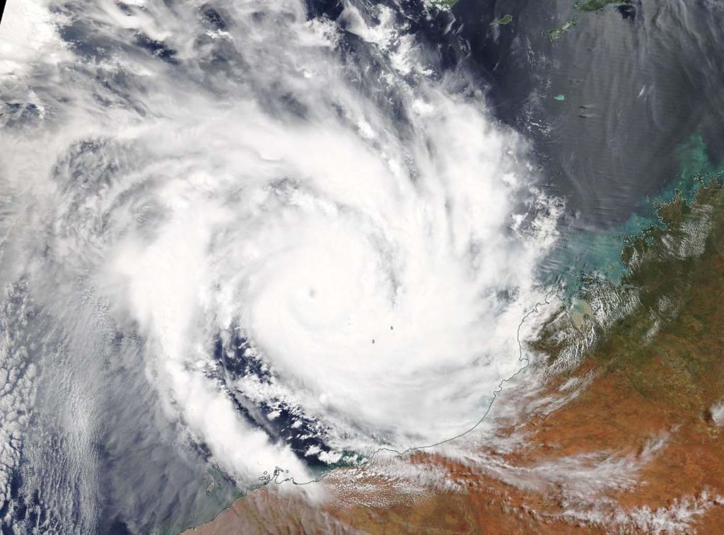
Early on March 26, Tropical Cyclone Veronica continued to move along the coast of Western Australia and NASA-NOAA’s Suomi NPP satellite provided a visible image of the storm that showed the storm was stripped of strong thunderstorm development around the center.

Suomi NPP image of Veronica
NASA-NOAA’s Suomi NPP satellite passed over the Southern Indian Ocean and captured a visible image of a rapidly dissipating Tropical Cyclone Veronica on March 26, along the coast of Western Australia. Credit: NASA Worldview, Earth Observing System Data and Information System (EOSDIS).

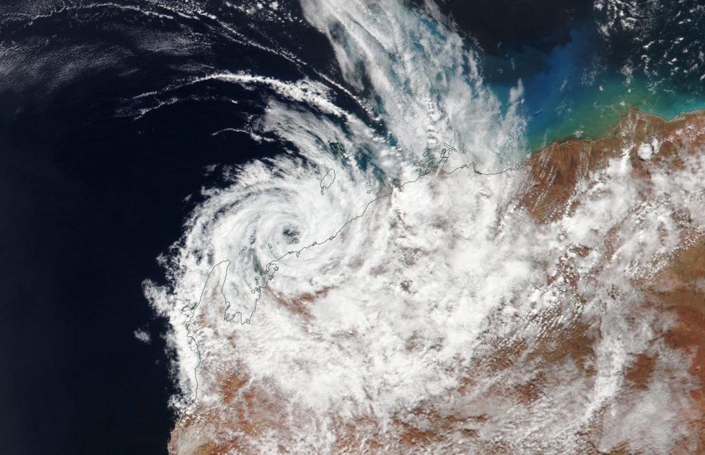
Suomi NPP passed over Veronica on March 26 and the Visible Infrared Imaging Radiometer Suite (VIIRS) instrument provided a visible image of the storm. The VIIRS image revealed that the storm weakened and the center cleared of clouds from the previous day. The cause of the raid weakening was strong vertical wind shear. Winds blowing at different levels in the atmosphere at strong speeds tore the storm apart.

In the image, the eastern and southern quadrant of Veronica was over land, while the rest of the storm was over the Southern Indian Ocean. However due to the strong winds Veronica is rapidly deteriorating and is expected to dissipate by the end of the day on March 26.

The Australian Bureau of Meteorology or ABM said the marine warning has been canceled for

Pilbara Coast West and Ningaloo Coast. However, there are still warnings in effect on March 26: A Moderate Flood Warning is in effect for the De Grey River Catchment, a Flood Warning is in effect for the Pilbara Coastal Rivers and the Final Flood Watch has been posted for the Pilbara District Rivers.

The Joint Typhoon Warning Center issued their final advisory on Veronica at 11 p.m. EDT on March 25 (0300 UTC on March 26). At that time Veronica had maximum sustained winds near 35 knots (40 mph/65 kph). Veronica was located near 21.1 degrees South latitude and 115.4 degrees East longitude. That’s about 123 nautical miles northeast of Learmonth, Australia.

Veronica will continue to rapidly deteriorate and dissipate later in the day.

For updated local forecasts, visit: http://www.bom.gov.au

By Rob Gutro 
NASA’s Goddard Space Flight Center

Veronica (Southern Indian Ocean)

Mar. 25, 2019 – Satellite Tracks Tropical Cyclone Veronica Along Australia Coast

On March 25, Tropical Cyclone Veronica continued to move in southerly direction along the coast of Western Australia in the Southern Indian Ocean. NASA-NOAA’s Suomi NPP satellite provided a visible image of the storm.

Suomi NPP image of Veronica
NASA-NOAA’s Suomi NPP satellite passed over the Southern Indian Ocean and captured a visible image of Tropical Cyclone Veronica on March 25, as it continued moving along the coast of Western Australia. Credit: NASA Worldview, Earth Observing System Data and Information System (EOSDIS).

Suomi NPP passed over Veronica on March 25 and the Visible Infrared Imaging Radiometer Suite (VIIRS) instrument provided a visible image of the storm. The VIIRS image showed what appeared to be a cloud-filled eye just off the coast, surrounded by powerful thunderstorms. The eastern and southern quadrant of Veronica was over land, while the rest of the storm was over the Southern Indian Ocean.

The Australian Bureau of Meteorology or ABM said that Tropical Cyclone Veronica, located near Karratha, was moving slowly west southwest and is likely to weaken below tropical cyclone intensity early Tuesday. Heavy rain over the central Pilbara will ease during Tuesday.

The Warning zone for March 25, 2019 extended from Roebourne to Mardie, including Karratha, and adjacent inland areas.

ABM expects Veronica to move in a westerly direction with its eye remaining just off the coast. It is forecast to pass just north of Dampier and over Barrier Island on its west-southwestward track. ABM noted that “widespread, very heavy rainfall conducive to major flooding is likely over the central Pilbara coast and adjacent inland areas, easing gradually during Tuesday. Heavy rainfall is expected to result in significant river rises, areas of flooding and hazardous road conditions. Some roads may become impassable and some communities may become isolated.”

At 11 a.m. EDT or 11:00 p.m. Australian Western Standard Time (AWST) the ABM said that Veronica has maximum sustained winds near 75 kph (46 mph). Veronica was located near   20.4 degrees South latitude and 116.7 degrees East longitude. That’s about 30 kilometers (18.6 miles) north of Dampier.

The cyclone is a category one system currently located just off the central Pilbara coast, north of Karratha. Veronica is expected to move towards the west southwest and is likely to weaken below tropical cyclone intensity early Tuesday morning.

For updated forecasts, visit: http://www.bom.gov.au

By Rob Gutro 
NASA’s Goddard Space Flight Center

Veronica (Southern Indian Ocean)

March 22, 2019 – Powerful Tropical Cyclone Veronica Eyes Australia’s Pilbara Coast
NASA-NOAA’s Suomi NPP satellite passed over the Southern Indian Ocean and captured a visible image of Severe Tropical Cyclone Veronica on March 22 as it moved toward the Pilbara Coast of Western Australia. Veronica was illuminated by the full moon. Credit: NASA/NOAA/UWM-CIMSS, William Straka III

Tropical Cyclone Veronica continued to move toward Australia’s Pilbara Coast in Western Australia. NASA-NOAA’s Suomi NPP satellite provided visible and infrared images of the storm that indicated heavy rainfall.

The Australian Bureau of Meteorology, or ABM updated warnings on March 22. The Warning zone extends from Wallal Downs to Mardie including Port Hedland, Karratha and Barrow Island.

The Watch zone extends to the inland Pilbara to include Pannawonica, Marble Bar and Nullagine.

NASA-NOAA's Suomi NPP satellite passed over the Southern Indian Ocean and captured a visible image of Severe Tropical Cyclone Veronica on March 22 as it moved toward the Pilbara Coast of Western Australia. Veronica was illuminated by the full moon. Credit: NASA/NOAA/UWM-CIMSS, William Straka III
NASA-NOAA’s Suomi NPP satellite passed over the Southern Indian Ocean and captured a visible image of Severe Tropical Cyclone Veronica on March 22 as it moved toward the Pilbara Coast of Western Australia. The infrared channel on VIIRS showed large amounts of tropospheric gravity waves and overshooting [cloud] tops associated with the intense convection. Credit: NASA/NOAA/UWM-CIMSS, William Straka III
Suomi NPP passed over Savannah on March 22 and the Visible Infrared Imaging Radiometer Suite (VIIRS) instrument provided visible and infrared images of the storm. William Straka III, who created some of the images noted “As you would expect, the infrared channel on VIIRS showed large amounts of tropospheric gravity waves and overshooting [cloud] tops associated with the intense convection. In another image Veronica was illuminated by the full moon.”

Shortly after the Suomi NPP satellite passed over the storm, the GCOM-W1 satellite also flew over Severe Tropical Cyclone Veronica. “The Advanced Microwave Scanning Radiometer or AMSR2 instrument aboard GCOM-W1 showed a completely enclosed eye as well as the convection around the circulation,” Straka said. The microwave instruments provide critical information that is not seen by the infrared or visible imagery for forecasters.

As of 9:02 a.m. EDT (9:02 p.m. AWST local time) on March 22, Severe Tropical Cyclone Veronica was a category 4 storm on the Australian scale. Veronica had sustained winds of 175 kilometers per hour. It was centered near 17.9 degrees south latitude and 116.9 degrees east longitude about 315 kilometers north of Karratha.

ABM noted “Severe Tropical Cyclone Veronica, a Category 4 system, is moving slowly southwards towards the Pilbara coast. During Saturday it is expected to take a more southeast track and reach the coast late Saturday or Sunday. A severe coastal impact is likely.”

For updated forecasts, visit ABM: http://www.bom.gov.au/

By Rob Gutro
NASA’s Goddard Space Flight Center, Greenbelt, Md.

Veronica (Southern Indian Ocean)

Mar. 21, 2019 – NASA Sees Tropical Cyclone Veronica Affecting Australia’s Pilbara Coast

Visible imagery from NASA’s Terra satellite showed Tropical Cyclone Veronica skirting the Pilbara coast of Western Australia.

Terra image of Veronica
On March 21, 2019, the MODIS instrument aboard NASA’s Terra satellite provided a visible image of Tropical Cyclone Veronica in the Southern Indian Ocean, and affecting the Pilbara coast of Western Australia. Credit: NASA Worldview, Earth Observing System Data and Information System (EOSDIS)

On March 21 the Moderate Resolution Imaging Spectroradiometer or MODIS instrument aboard NASA’s Terra satellite provided a visible image of Veronica. Veronica had a 10 nautical mile wide pinhole eye surrounded by powerful thunderstorms. Bands of thunderstorms spiraled into the center of circulation from the northwest and east. Veronica’s southeastern quadrant was spreading clouds along the Pilbara coastline of northern Western Australia.

The Australian Bureau of Meteorology or ABM updated warnings and watches on March 21, 2019. The Warning zone stretches from Pardoo to Mardie including Port Hedland, Karratha and Barrow Island. The Watch zone stretches from Pardoo to Wallal Downs, Mardie to Onslow and extending to the inland Pilbara to include Pannawonica, Tom Price and Marble Bar.

At 8:48 a.m. EDT (8:48 p.m. AWST Australian Western Standard Time) on March 21, 2019, maximum sustained winds near Veronica’s center were near 121 miles (195 kilometers) per hour. Veronica was centered near 17.3 degrees south latitude and 117.3 degrees east longitude. That’s about 223 miles (360 kilometers) north-northwest of Port Hedland and 239 miles (385 kilometers) north of Karratha.

AMB noted in that advisory, “Severe Tropical Cyclone Veronica, a Category 4 system, is moving slowly towards the Pilbara coast. The cyclone should continue its south to southwest track tonight and Friday before taking a more south southeast track on Saturday. Whilst it is possible that the cyclone may weaken before reaching the Pilbara coast, a severe coastal impact is likely.”

ABM forecasts Veronica to move in a southerly direction and make landfall on March 24, near Whim Creek. Whim Creek is located between Port Hedland to the northeast and Exmouth to the southwest.

For updated forecasts from the Australian Bureau of Meteorology, visit: http://www.bom.gov.au

By Rob Gutro
NASA’s Goddard Space Flight Center

Veronica (Southern Indian Ocean)

Mar. 20, 2019 – NASA’s Aqua Satellite Sees Tropical Cyclone Veronica Develop Off Western Australia’s Coast

NASA’s Aqua satellite provided a view of Tropical Cyclone Veronica after it developed off the northern coast of Western Australia.

Aqua image of Veronica
On March 20, 2019, the MODIS instrument aboard NASA’s Aqua satellite provided a visible image of Tropical Cyclone Veronica in the Southern Indian Ocean, off the coast of Western Australia. Credit: NASA Worldview, Earth Observing System Data and Information System

On March 20, 2019 the Moderate Resolution Imaging Spectroradiometer or MODIS instrument aboard NASA’s Aqua satellite captured a visible image of the storm that revealed bands of thunderstorms spiraling into the center of circulation. The Joint Typhoon Warning Center noted that the system continued to consolidate as rain bands wrapped tighter toward a pinhole formative eye. When Aqua passed over Veronica, the storm’s southeastern quadrant was brushing the Dampier Peninsula. That peninsula is located north of Broome and Roebuck Bay in Western Australia and bordered by the Indian Ocean to the west and north and King Sound to the east.

Although there are not yet any warnings in place, the Australian Bureau of Meteorology or ABM has posted a watch area from Pardoo to Mardie, including Port Hedland and Karratha, Western Australia. A Blue Alert is in effect for people in or near communities between Mardie and Pardoo, including Port Hedland, South Hedland, Wickham, Roebourne, Point Samson, Karratha and Dampier. ABM recommends those residents to prepare for cyclonic weather and organize an emergency kit including first aid kit, torch, portable radio, spare batteries, food and water.

At 8:47 a.m. EDT (8:47 p.m. AWST Australia local time) on March 20, 2019, maximum sustained winds near Veronica’s center were near 75 miles (120 kilometers) per hour, making it a Category 1 hurricane on the Saffir-Simpson Hurricane Wind Scale. Trevor was centered near 15.8 degrees south latitude and 118.0 degrees east longitude. That’s about 314 miles (505 kilometers) north of Port Hedland. ABM noted “The cyclone is expected to continue tracking west southwest tonight and during Thursday, March 21. On Friday, March 22, the system will intensify further as it adopts a more southerly track, towards the Pilbara coast.”

ABM forecasts that Veronica will turn to the south and head toward Karratha by March 23. Residents along the Pilbara coast should prepare for Veronica.

For updated forecasts from the Australian Bureau of Meteorology, visit: http://www.bom.gov.au

By Rob Gutro
NASA’s Goddard Space Flight Center