Belna (02S) – Southern Indian Ocean

Dec. 11, 2019 – NASA Finds Tropical Storm Belna’s Heavy Rainfall Potential Shrinks

Tropical Storm Belna weakened after it made landfall in northwestern Madagascar, and infrared imagery from NASA showed how the area of strong storms within had diminished.  Cold cloud top temperatures can tell forecasters if a tropical cyclone has the potential to generate heavy rainfall, and that is exactly what NASA’s Aqua satellite found on Dec. 10 over a much smaller area than was occurring on Dec. 9.

AIRS image of Belna
On Dec. 10 at 6:47 a.m. EST (1047 UTC) NASA’s Aqua satellite analyzed Tropical Storm Belna using the Atmospheric Infrared Sounder or AIRS instrument. AIRS found coldest cloud top temperatures (purple) as cold as or colder than minus 63 degrees Fahrenheit (minus 53 degrees Celsius) in a small area over northwestern Madagascar. Credit: NASA JPL/Heidar Thrastarson

The AIRS instrument aboard NASA’s Aqua satellite captured a look at cloud top temperatures in Belna which gave insight into the storm’s strength. Cloud top temperatures provide information to forecasters about where the strongest storms are located within a tropical cyclone. Tropical cyclones do not always have uniform strength, and some sides are stronger than others. The stronger the storms, the higher they extend into the troposphere, and the colder the cloud temperatures are.

On Dec. 10 at 6:47 a.m. EST (1047 UTC) NASA’s Aqua satellite analyzed the storm using the Atmospheric Infrared Sounder or AIRS instrument. AIRS found the strongest storms with coldest cloud top temperatures as cold as or colder than minus 63 degrees Fahrenheit (minus 53 degrees Celsius) in a small area over northwestern Madagascar. NASA research has shown that cloud top temperatures that cold indicate strong storms that have the capability to create heavy rain.

By Dec. 11 at 4 a.m. EST (0900 UTC), Belna had become devoid of all heavy rainfall, and the forecasters at the Joint Typhoon Warning Center (JTWC) issued their final bulletin on the storm.   Belna had weakened to a tropical depression and had maximum sustained winds near 30 knots (34.5 mph/55.5 kph).

Belna was located near latitude 21.3 degrees south and longitude 45.4 degrees east. It was over land and just six nautical miles southwest of Antananarivo, Madagascar. Belna was moving south and is expected to dissipate in a day or two.

Tropical cyclones and hurricanes are the most powerful weather events on Earth. NASA’s expertise in space and scientific exploration contributes to essential services provided to the American people by other federal agencies, such as hurricane weather forecasting.

The AIRS instrument is one of six instruments flying on board NASA’s Aqua satellite, launched on May 4, 2002.

By Rob Gutro
NASA’s Goddard Space Flight Center   

Belna (was 02S) – Southern Indian Ocean

Dec. 10, 2019 – NASA’s Temp Check on Tropical Storm Belna Finds Heavy Rainfall Potential

Cold cloud top temperatures can tell forecasters if a tropical cyclone has the potential to generate heavy rainfall, and that is exactly what NASA’s Aqua satellite found when it observed the temperatures in Tropical Cyclone Belna over northwestern Madagascar.

Aqua image of Belna
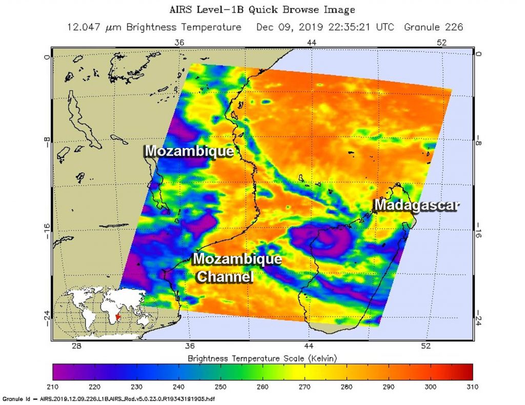
On Dec. 9 at 5:35 p.m. EST (2235 UTC) NASA’s Aqua satellite analyzed Tropical Storm Belna using the Atmospheric Infrared Sounder or AIRS instrument. AIRS found coldest cloud top temperatures (purple) as cold as or colder than minus 63 degrees Fahrenheit (minus 53 degrees Celsius) around the center and in a band of thunderstorms east of center over northwestern Madagascar. Credit: NASA JPL/Heidar Thrastarson

One of the ways NASA researches tropical cyclones is using infrared data that provides temperature information. The AIRS instrument aboard NASA’s Aqua satellite captured a look at those temperatures in Belna and gave insight into the storm’s strength.

Cloud top temperatures provide information to forecasters about where the strongest storms are located within a tropical cyclone. Tropical cyclones do not always have uniform strength, and some sides have stronger sides than others. The stronger the storms, the higher they extend into the troposphere, and the colder the cloud temperatures are.

On Dec. 9 at 5:35 p.m. EST (2235 UTC) NASA’s Aqua satellite analyzed the storm using the Atmospheric Infrared Sounder or AIRS instrument. AIRS found coldest cloud top temperatures as cold as or colder than minus 63 degrees Fahrenheit (minus 53 degrees Celsius) around the center and in a band of thunderstorms east of center over northwestern Madagascar. NASA research has shown that cloud top temperatures that cold indicate strong storms that have the capability to create heavy rain.

ReliefWeb reported that Belna made landfall in Soalala district in the west of Madagascar during the afternoon on Dec. 9. The rainfall that was evident in the AIRS infrared imagery occurred upon landfall, coupled with strong winds.

On Dec. 10 at 4 a.m. EST (0900 UTC), forecasters at the Joint Typhoon Warning Center (JTWC) noted that Belna had weakened to a tropical storm and had maximum sustained winds near 60 knots (69 mph/111 kph). Belna was moving to the south.

Belna was located near latitude 18.3 degrees south and longitude 44.8 degrees east. It was over land in west-central Madagascar and about 349 nautical miles northeast of Europa Island. Europa Island is a tropical atoll in the Mozambique Channel. It is located about one-third of the way between southern Madagascar and Mozambique.

The JTWC forecast calls for Belna to move south-southeast across Madagascar. The storm will slowly weaken and is expected to dissipate in south central Madagascar by Dec. 12.

Tropical cyclones and hurricanes are the most powerful weather events on Earth. NASA’s expertise in space and scientific exploration contributes to essential services provided to the American people by other federal agencies, such as hurricane weather forecasting.

The AIRS instrument is one of six instruments flying on board NASA’s Aqua satellite, launched on May 4, 2002.
By Rob Gutro
NASA’s Goddard Space Flight Center   

Belna (was 02S) – Southern Indian Ocean

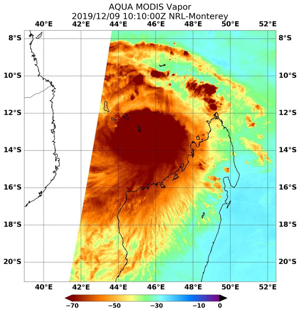
Dec. 09, 2019 – NASA Examines Tropical Cyclone Belna’s Water Vapor Concentration

When NASA’s Aqua satellite passed over the Southern Indian Ocean, water vapor data provided information about the intensity of Tropical Cyclone Belna.

Aqua image of Belna
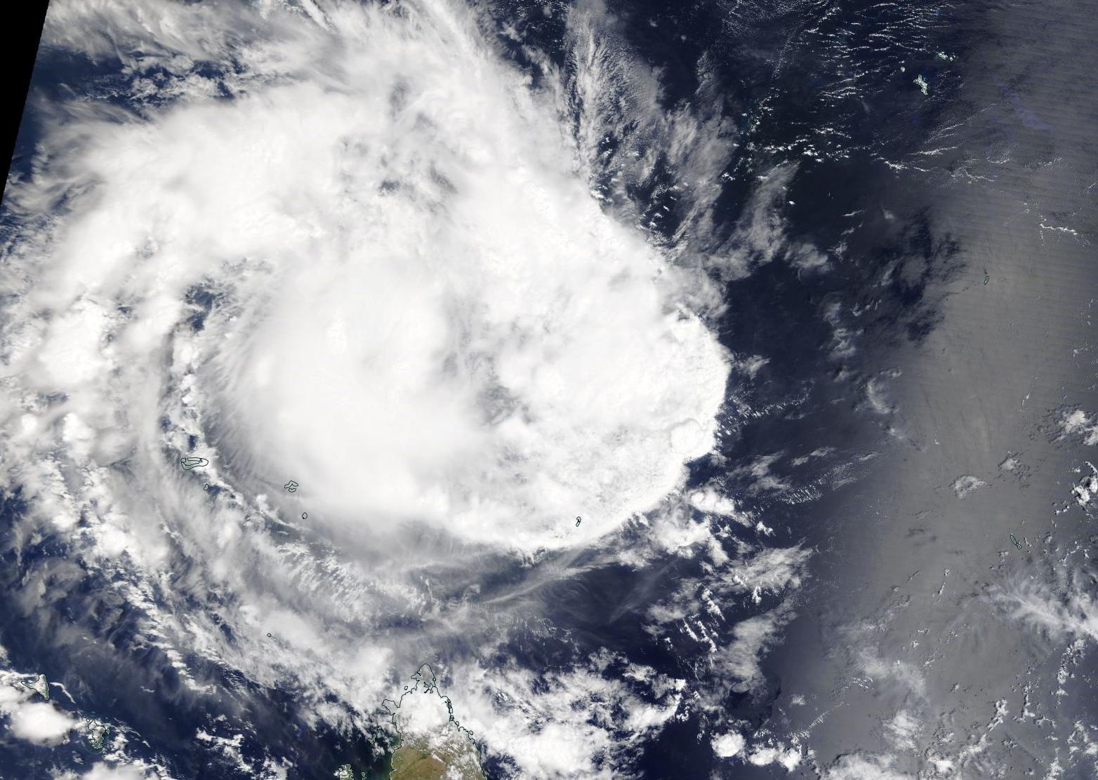
NASA’s Aqua satellite passed over Tropical Cyclone Belna in the Southern Indian Ocean on Dec. 9 at 5:10 a.m. EST (1010 UTC). Aqua found the highest concentrations of water vapor (brown) and coldest cloud top temperatures were around the center. Credits: NASA/NRL

NASA’s Aqua satellite passed over Belna on Dec. 9 at 5:10 a.m. EST (1010 UTC) and the Moderate Resolution Imaging Spectroradiometer or MODIS instrument gathered water vapor content and temperature information. The MODIS image showed highest concentrations of water vapor and coldest cloud top temperatures were encircling the center. MODIS data also showed coldest cloud top temperatures were as cold as or colder than minus 70 degrees Fahrenheit (minus 56.6 degrees Celsius) in those storms. Storms with cloud top temperatures that cold have the capability to produce heavy rainfall.

Water vapor analysis of tropical cyclones tells forecasters how much potential a storm has to develop. Water vapor releases latent heat as it condenses into liquid. That liquid becomes clouds and thunderstorms that make up a tropical cyclone. Temperature is important when trying to understand how strong storms can be. The higher the cloud tops, the colder and stronger they are.

At 5 a.m. EDT (0900 UTC), Belna was located near latitude 14.6 degrees south and longitude 45.6 degrees east, about 550 nautical miles northeast of Europa Island. Belna is moving south-southwest toward northwestern Madagascar. Maximum sustained winds are near 80 knots (92 mph/148 kph).

Forecasters at the Joint Typhoon Warning Center expect Belna will move south-southwest and continue weakening before making landfall in northwestern Madagascar  near Soalala by Dec. 9 at 1800 UTC (1 p.m. EST) with maximum sustained winds expected near 75 knots (86 mph/139 kph).

NASA’s Aqua satellite is one in a fleet of NASA satellites that provide data for hurricane research.

Tropical cyclones and hurricanes are the most powerful weather events on Earth. NASA’s expertise in space and scientific exploration contributes to essential services provided to the American people by other federal agencies, such as hurricane weather forecasting.

For updated warnings from METEO Madagascar, visit: http://www.meteomadagascar.mg/cyclone

By Rob Gutro
NASA’s Goddard Space Flight Center

Belna (was 02S) – Southern Indian Ocean

Dec. 06, 2019 – NASA Finds Strengthening Tropical Cyclone Belna North of Madagascar

NASA’s Aqua satellite captured a visible image of Tropical Cyclone Belna, located north of Madagascar in the Southern Indian Ocean. Imagery shows that the storm to be strengthening.

satellite image of cyclone
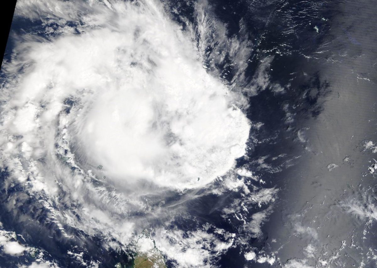
On Dec. 6, 2019, the MODIS instrument that flies aboard NASA’s Aqua satellite provided a visible image of Tropical Cyclone Belna, north of Madagascar in the Southern Indian Ocean. Credit: NASA Worldview

On Dec. 6, 2019, the Moderate Imaging Spectroradiometer or MODIS instrument that flies aboard NASA’s Aqua satellite provided a visible image of Belna, formerly known as 02S. The image showed bands of thunderstorms wrapping into the low-level center from the west. Animated multispectral satellite imagery shows deep, rapidly cycling convection wrapping into a well-defined low-level circulation center.

At 10 a.m. EST (1500 UTC) on Dec. 6, the Joint Typhoon Warning Center or JTWC noted that Tropical Cyclone Belna was located near 7.9 degrees south latitude and 48.7 degrees east longitude. That is about 863 nautical miles west-southwest of St. Denis, La Reunion Island. Belna is moving to the southwest. Maximum sustained winds 55 knots (63 mph/102 kph).

Forecasters at the JTWC said that Belna is expected to turn to the south-southwest. The storm is forecast to intensify to 90 knots (104 mph/167 kph) before making landfall in northwestern Madagascar after four days.

NASA’s Aqua satellite is one in a fleet of NASA satellites that provide data for hurricane research.

Tropical cyclones are the most powerful weather event on Earth. NASA’s expertise in space and scientific exploration contributes to essential services provided to the American people by other federal agencies, such as hurricane weather forecasting.

By Rob Gutro
NASA’s Goddard Space Flight Center

02S – Southern Indian Ocean

Dec. 05, 2019 – NASA Finds Tropical Cyclone 02S Consolidating

NASA’s Aqua satellite captured an image of Tropical cyclone 02S and the visible image showed that the storm was becoming better organized.

Aqua image of 02S
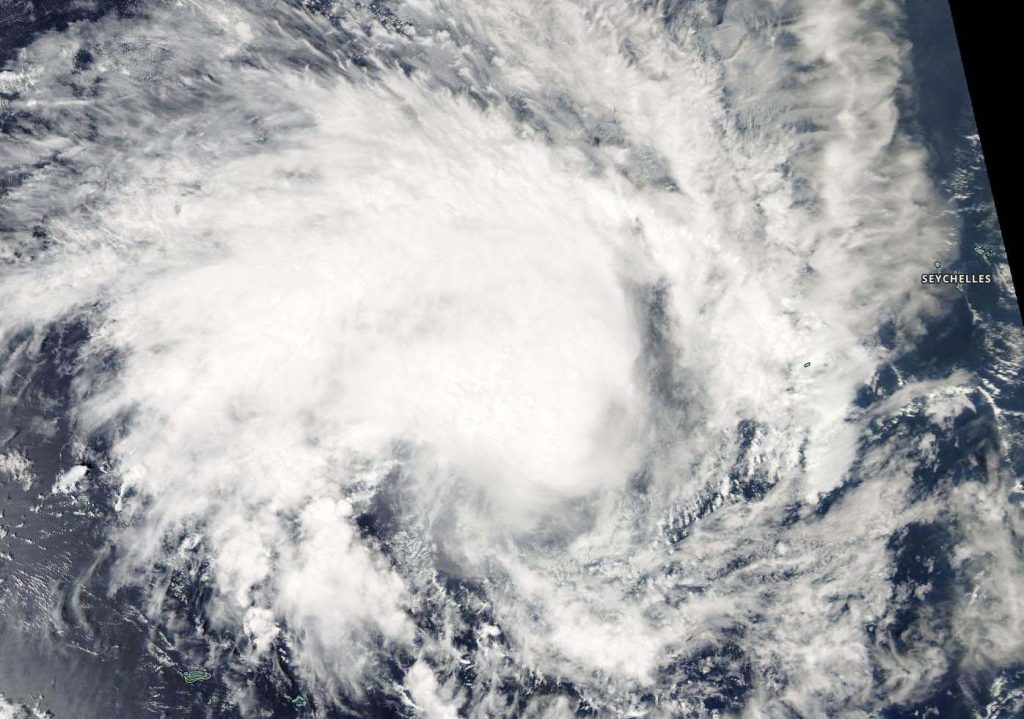
On Dec. 5 2019, the MODIS instrument that flies aboard NASA’s Aqua satellite provided a visible image of Tropical Cyclone 02S in the Southern Indian Ocean and showed powerful storms around the center of circulation and a large band of thunderstorms feeding into the center from the west. Credit: NASA Worldview, Earth Observing System Data and Information System (EOSDIS)

Tropical Cyclone 02A formed as a tropical depression in the Southern Indian Ocean on Dec. 4 and strengthened into a tropical storm.

On Dec. 5, the Moderate Resolution Imaging Spectroradiometer or MODIS instrument that flies aboard NASA’s Aqua satellite provided a visible image of 02S. The MODIS image showed powerful thunderstorms circling the center of circulation and a large, thick band of thunderstorms feeding into the center from the west.

The shape of the storm is a clue to forecasters that a storm is either strengthening or weakening. If a storm takes on a more rounded shape it is getting more organized and strengthening. Conversely, if it becomes less rounded or elongated, it is a sign the storm is weakening. 02S appeared more circular than it did 24 hours before, indicating it was strengthening and consolidating.

On Dec. 5 at 4 a.m. EST (0900 UTC), Tropical Cyclone 02S was located near latitude 6.7 degrees south and longitude 50.9 degrees east, about 867 miles north-northwest of St Denis, La Reunion Island. 02S is moving west-southwest and has maximum sustained winds 40 knots (46 mph/74 kph).

Tropical Cyclone 02S is forecast to turn to the south-southwest. The storm is forecast to make landfall in northwestern Madagascar after five days.

NASA’s Aqua satellite is one in a fleet of NASA satellites that provide data for hurricane research.

Tropical cyclones and hurricanes are the most powerful weather events on Earth. NASA’s expertise in space and scientific exploration contributes to essential services provided to the American people by other federal agencies, such as hurricane weather forecasting.

By Rob Gutro
NASA’s Goddard Space Flight Center