06W – Northwestern Pacific Ocean

Aug. 12, 2020 – NASA-NOAA’s Suomi NPP Satellite Finds a Stubborn Tropical Depression 06W

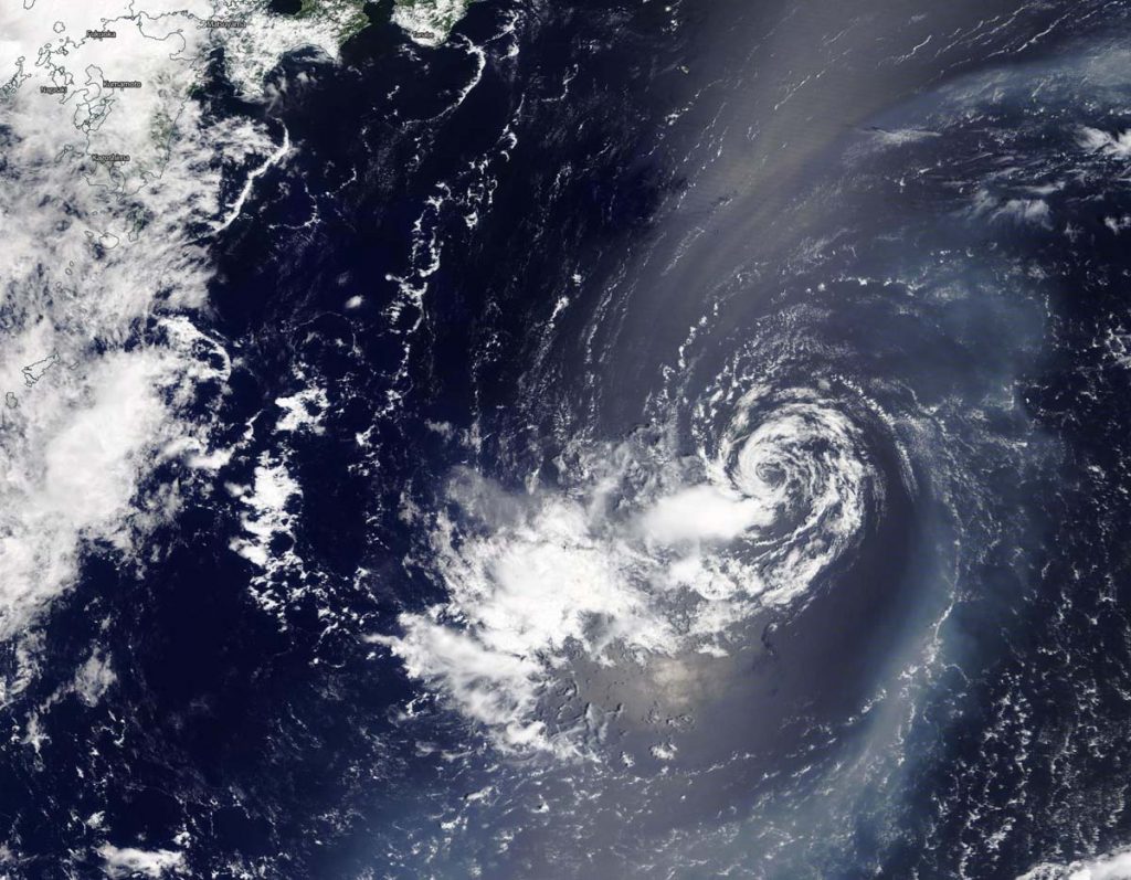
Tropical Depression 06W has been around for days, and continues to hold together as it moves in a westerly direction toward Taiwan in the Northwestern Pacific Ocean. NASA-NOAA’s Suomi NPP satellite captured a visible image of the storm.

Suomi NPP image of 06W
NASA-NOAA’s Suomi NPP satellite provided forecasters with a visible image of Tropical Depression 06W moving through the Northwestern Pacific Ocean on Aug. 12. Credit: NASA Worldview, Earth Observing System Data and Information System (EOSDIS)

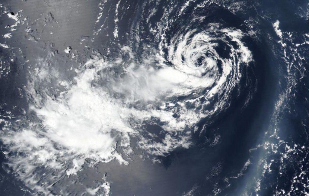
On Aug. 12, the Visible Infrared Imaging Radiometer Suite (VIIRS) instrument aboard Suomi NPP revealed a partially exposed low-level circulation with building thunderstorms over the western quadrant of Tropical Depression 06W. Satellite imagery also showed a weakly defined, broad center. The image was created by NASA Worldview website at NASA’s Goddard Space Flight Center in Greenbelt, Md.

At 11 a.m. EDT (1500 UTC) on Aug. 12, the Joint Typhoon Warning Center (JTWC) noted Tropical Depression 06W (TD06W) was centered near latitude 5.0 degrees north and longitude 133.4 degrees east, approximately 349 nautical miles east-southeast of Kadena Air Base, Okinawa Island, Japan. 06W was moving to the west-southwest. Maximum sustained winds remained near 25 knots (29 mph/46 kph).

TD06W is expected to maintain intensity for another day and a half, when it will then weaken.

NASA Researches Tropical Cyclones

Hurricanes/tropical cyclones are the most powerful weather events on Earth. NASA’s expertise in space and scientific exploration contributes to essential services provided to the American people by other federal agencies, such as hurricane weather forecasting.

For more than five decades, NASA has used the vantage point of space to understand and explore our home planet, improve lives and safeguard our future. NASA brings together technology, science, and unique global Earth observations to provide societal benefits and strengthen our nation. Advancing knowledge of our home planet contributes directly to America’s leadership in space and scientific exploration.

By Rob Gutro 
NASA’s Goddard Space Flight Center

06W – Northwestern Pacific Ocean

Aug. 11, 2020 – NASA Finds a Wispy, Wind-Sheared Tropical Depression 06W  

NASA’s Terra satellite revealed that a wispy looking Tropical Depression 06W in the Northwestern Pacific Ocean was being battered by wind shear. That wind shear is not expected to wane and the storm is expected to weaken.

Terra image of 06W
On Aug. 11, 2020, NASA’s Terra satellite provided a visible image of Tropical Depression 06W in the Northwestern Pacific Ocean that showed a ring of wispy clouds around a fully-exposed, well-defined, low-level center of circulation. It also showed that any precipitation and thunderstorms were pushed to the south-southwest of the center from vertical wind shear. Japan is located in the top left of this image. Credit: NASA/NRL

Tropical Depression 06W formed two days ago on August 9 by 11 a.m. EDT (1500 UTC) near latitude 26.1 degrees north and longitude 147.6 east, about 250 nautical miles east-northeast of Iwo To Island, Japan. 06W briefly strengthened to a tropical storm by 5 p.m. EDT (2100 UTC) when maximum sustained winds reached 45 knots (52 mph/83 kph). By Aug. 10 at 11 a.m. EDT (1500 UTC) the storm had weakened back to tropical depression status.

On Aug. 11, 2020, the Moderate Resolution Imaging Spectroradiometer or MODIS instrument that flies aboard NASA’s Terra satellite provided forecasters at the Joint Typhoon Warning Center in Honolulu, Hawaii with a visible image of Tropical Depression 06W. The image showed a ring of wispy clouds around a fully-exposed, well-defined, low-level center of circulation. It also showed that any precipitation and thunderstorms were pushed to the south-southwest of the center from vertical wind shear.

Vertical wind shear, that is, winds outside of a tropical cyclone at different heights in the atmosphere (the troposphere) push against a tropical cyclone and tear it apart. Winds from the north-northeast were affecting 06W. In addition, dry air was moving into the storm and sapping the development of the thunderstorms that make up a tropical cyclone.

At 5 a.m. EDT (0900 UTC) on Aug. 11, the center of Tropical Depression 06W was located near latitude 26.6 degrees north and longitude 140.5 degrees east, about 681 nautical miles east of Kadena Air Base, Okinawa Island, Japan. 06W was moving to the west and had maximum sustained winds near 25 knots (29 mph/46 kph).

The Joint Typhoon Warning Center (JTWC) forecast notes that 06W will continue to move west and weaken before dissipating after a few days.

About NASA’s Worldview and Terra Satellite

NASA’s Earth Observing System Data and Information System (EOSDIS) Worldview application provides the capability to interactively browse over 700 global, full-resolution satellite imagery layers and then download the underlying data. Many of the available imagery layers are updated within three hours of observation, essentially showing the entire Earth as it looks “right now.”

NASA’s Terra satellite is one in a fleet of NASA satellites that provide data for hurricane research.

Tropical cyclones/hurricanes are the most powerful weather events on Earth. NASA’s expertise in space and scientific exploration contributes to essential services provided to the American people by other federal agencies, such as hurricane weather forecasting.

By Rob Gutro
NASA’s Goddard Space Flight Center