07A – Northern Indian Ocean

Dec. 04, 2019 – NASA Finds Wind Shear Battering Tropical Cyclone 07A

NASA’s Aqua satellite found that wind shear was tearing at Tropical Storm 07A in the Arabian Sea.

Aqua image of 07A
On Dec. 4 at 3:20 a.m. EST (0820 UTC), the MODIS instrument aboard NASA’s Aqua satellite gathered temperature information about Tropical Storm 07A’s cloud tops. MODIS found three small areas of powerful thunderstorms (red) where temperatures were as cold as or colder than minus 70 degrees Fahrenheit (minus 56.6 Celsius). MODIS also showed westerly wind shear was pushing the bulk of clouds east of the storm’s center. Credit: NASA/NRL

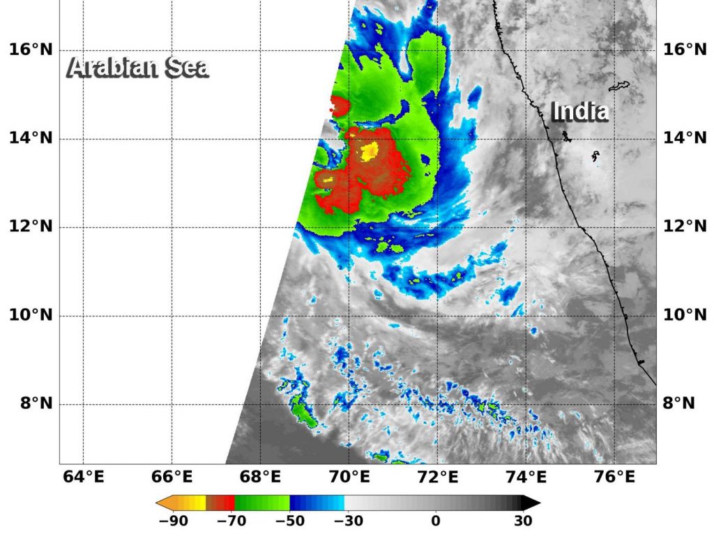
NASA’s Aqua satellite used infrared light to analyze the strength of storms in 07A. Infrared data provides temperature information, and the strongest thunderstorms that reach high into the atmosphere have the coldest cloud top temperatures. On Dec. 4 at 3:20 a.m. EST (0820 UTC), the Moderate Resolution Imaging Spectroradiometer or MODIS instrument aboard NASA’s Aqua satellite gathered temperature information about Tropical Storm 07A’s cloud tops. MODIS found three small areas of powerful thunderstorms where temperatures were as cold as or colder than minus 70 degrees Fahrenheit (minus 56.6 Celsius). Cloud top temperatures that cold indicate strong storms with the potential to generate heavy rainfall.

Cloud tops surrounding those small areas were warmer, indicating those storms were weaker. The bulk of thunderstorms in 07A were warmer than minus 70 degrees Fahrenheit and they were being pushed to the east from westerly wind shear.

In general, wind shear is a measure of how the speed and direction of winds change with altitude. Tropical cyclones are like rotating cylinders of winds. Each level needs to be stacked on top each other vertically in order for the storm to maintain strength or intensify. Wind shear occurs when winds at different levels of the atmosphere push against the rotating cylinder of winds, weakening the rotation by pushing it apart at different levels. Winds from the west were displacing the bulk of clouds and showers from 07A and pushing them to the east.

On Dec. 4 at 4 a.m., EST (0900 UTC), Tropical Storm 07A was located near latitude 14.9 degrees north and longitude 68.7 degrees east in the Arabian Sea, Northern Indian Ocean. That is about 616 nautical miles south of Karachi, Pakistan. 07A was moving to the northwest and had maximum sustained winds near 45 knots.

Tropical Storm 07A is expected to weaken to a depression by Dec. 5 and then dissipate.

Typhoons and hurricanes are the most powerful weather event on Earth. NASA’s expertise in space and scientific exploration contributes to essential services provided to the American people by other federal agencies, such as hurricane weather forecasting.

By Rob Gutro
NASA’s Goddard Space Flight Center

07A – Northern Indian Ocean

Dec. 03, 2019 – NASA Finds Second Tropical System Develops in Arabian Sea

Tropical Storm 07A has developed in the eastern Arabian Sea, one day after Tropical Storm 06A developed in the western part of the sea. Infrared imagery from an instrument aboard Terra revealed that very high, powerful storms with very cold cloud top temperatures were southwest of the center.

Terra image of 07A
On Dec. 3 at 12 pm. EST (1700 UTC) the MODIS instrument that flies aboard NASA’s Terra satellite showed the southeastern quadrant of newly formed Tropical Storm 07A where cloud top temperatures (in yellow) were as cold as or colder than minus 80 degrees Fahrenheit (minus 62.2 Celsius). Credit: NASA/NRL

Tropical Storm 07A developed on Dec. 2 from a low-pressure area designated as System 91A. The storm consolidated into a tropical storm today and was renamed 07A.

Tropical cyclones are made of up hundreds of thunderstorms, and infrared data can show where the strongest storms are located. They can do with infrared data that provides temperature information.  The strongest thunderstorms that reach highest into the atmosphere have the coldest cloud top temperatures.

On Dec. 3 at 12 pm. EST (1700 UTC) the Moderate Resolution Imaging Spectroradiometer or MODIS instrument that flies aboard NASA’s Terra satellite showed the southeastern quadrant of newly formed Tropical Storm 07A where cloud top temperatures (in yellow) were as cold as or colder than minus 80 degrees Fahrenheit (minus 62.2 Celsius). NASA research has found that cloud top temperatures that cold indicate strong storms with the potential to generate heavy rainfall.

On Dec. 3 at 10 a.m. EDT (1500 UTC), Tropical Storm 07A had maximum sustained winds near 35 knots (40 mph /65 kph). It was located near latitude 13.4 degrees north and longitude 70.2 degrees east, about 367 nautical miles south-southwest of Mumbai, India.

Forecasters at the Joint Typhoon Warning Center expect 07A will move northwest. The system is not expected to intensify and is expected to dissipate in a day or so.

Tropical cyclones are the most powerful weather event on Earth. NASA researches these storms to determine how they rapidly intensify, develop and behave. NASA’s expertise in space and scientific exploration contributes to essential services provided to the American people by other federal agencies, such as hurricane weather forecasting.

By Rob Gutro
NASA’s Goddard Space Flight Center