Nari (was 07W) – Northwestern Pacific Ocean

July 26, 2019 – NASA Finds Two Areas of Strength in Tropical Storm Nari

NASA’s Terra satellite found two small areas of strength in Tropical Storm Nari on July 26 as it began to affect Japan.

Terra image of Nari
On July 26 at 8:20 a.m. EDT (1220 UTC), the MODIS instrument that flies aboard NASA’s Terra satellite showed two areas of strongest storms (yellow) in Tropical Storm Nari north and south of center. Cloud top temperatures in those areas were as cold as minus 50 degrees Fahrenheit (minus 45.5 Celsius). Credit: NASA/NRL

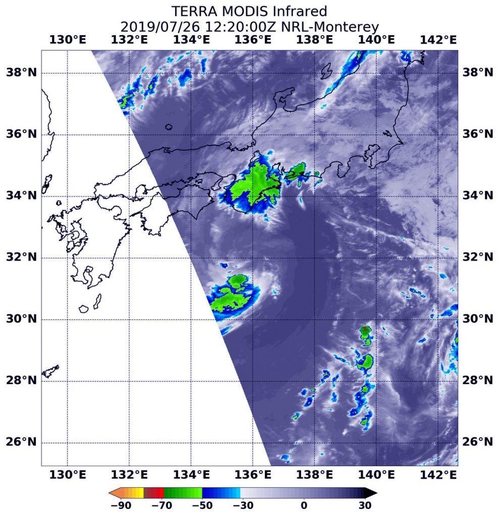
NASA’s Terra satellite uses infrared light to analyze the strength of storms by providing temperature information about the system’s clouds. The strongest thunderstorms that reach high into the atmosphere have the coldest cloud top temperatures.

On July 26 at 8:20 a.m. EDT (1220 UTC), the Moderate Imaging Spectroradiometer or MODIS instrument that flies aboard NASA’s Terra satellite gathered infrared data on Nari, formerly known as Tropical Storm 07W. There were two areas of strongest storms in Tropical Storm Nari, and they were north and south of the center of circulation. In those areas, thunderstorms had cloud top temperatures as cold as minus 50 degrees Fahrenheit (minus 45.5 Celsius). That northernmost area of strong storms was located over the Kyoto, Osaka and Wakayama Prefectures of Japan.

At 5 a.m. EDT (0900 UTC), the center of Tropical Storm Nari was located near latitude 30.9 degrees north and longitude 136.3 degrees east. That’s about 314 nautical miles southwest of Yokosaka, Japan. The tropical storm is moving toward the north-northwest. Maximum sustained winds were near 40 mph (35 knots/64 kph).

The Joint Typhoon Warning Center (JTWC) forecast for Nari brings the storm northward, with a turn to the east in 12 hours. JTWC said “The system is expected to maintain intensity prior to Landfall in Honshu. The system is expected to dissipate by 48 hours due to passage over land and cooler water to the east of Honshu.”

By Rob Gutro
NASA’s Goddard Space Flight Center

07W – Northwestern Pacific Ocean

July 25, 2019 – NASA’s Terra Satellite Finds Tropical Storm 07W’s Strength on the Side 

Wind shear can push clouds and thunderstorms away from the center of a tropical cyclone and that’s exactly what infrared imagery from NASA’s Terra satellite shows is happening in newly formed Tropical Storm 07W.

Terra image of 07W
On July 25 at 9:15 a.m. EDT (1315 UTC) the MODIS instrument that flies aboard NASA’s Terra satellite showed strongest storms in Tropical Storm 07W were east of the elongated center where cloud top temperatures were as cold as minus 70 degrees Fahrenheit (in red) (minus 56.6 Celsius). Credit: NASA/NRL

NASA’s Terra satellite used infrared light to analyze the strength of storms and found the bulk of them on the eastern side of the storm. Infrared data provides temperature information, and the strongest thunderstorms that reach high into the atmosphere have the coldest cloud top temperatures.

On July 25 at 9:15 a.m. EDT (1315 UTC), the Moderate Imaging Spectroradiometer or MODIS instrument that flies aboard Terra gathered infrared data on 07W and showed the strongest thunderstorms had cloud top temperatures as cold as minus 70 degrees Fahrenheit (minus 56.6 Celsius). Cloud top temperatures that cold indicate strong storms with the potential to generate heavy rainfall.

The storm is being affected my moderate vertical wind shear from the southwest. In general, wind shear is a measure of how the speed and direction of winds change with altitude. Tropical cyclones are like rotating cylinders of winds. Each level needs to be stacked on top each other vertically in order for the storm to maintain strength or intensify. Wind shear occurs when winds at different levels of the atmosphere push against the rotating cylinder of winds, weakening the rotation by pushing it apart at different levels. Wind shear can displace the clouds and showers of the system from around the center.

The Joint Typhoon Warning Center or JTWC noted at 11 a.m. EDT (1500 UTC) on July 25 that Tropical Storm 07W was located near 27.5 degrees north latitude and 137.4 east longitude, about 483 miles south-southwest of Yokosuka, Japan. 07W is moving to the north and has maximum sustained winds near 35 knots (40 mph/62 kph).

The JTWC forecast calls for 07W to move north. Once it reaches Japan, the system is expected to turn to the east-northeast and dissipate.

By Rob Gutro
NASA’s Goddard Space Flight Center