Blake – Southern Indian Ocean

Jan. 10, 2020 – NASA Satellite Sees Blake’s Remnants Bringing Desert Rain to Western Australia   

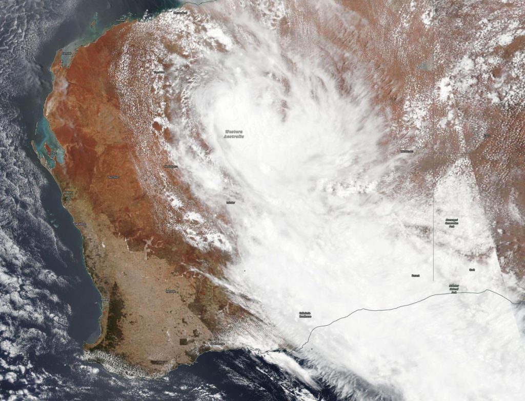
NASA’s Aqua satellite provided a look at the remnant clouds and storms associated with Ex-tropical Cyclone Blake as it continues to move through Western Australia and generate rainfall over desert areas. Blake’s rainfall has triggered four area flood warnings in some parts of southeastern Western Australia. The remnants have dropped over 10 inches of rain in the Sandy Desert.

Aqua image of remnants of Blake
On Jan. 10, 2020, the MODIS instrument that flies aboard NASA’s Aqua satellite provided a visible image of Ex-tropical storm Blake covering part of Western Australia and still generating enough precipitation to call for warnings. Credit: NASA Worldview

Slow moving ex-Tropical Cyclone Blake is continuing to track south southeast and is expected to weaken sometime on Friday.

On January 10, 2020, the Moderate Imaging Spectroradiometer or MODIS instrument that flies aboard NASA’s Aqua satellite provided a visible image of Blake. The MODIS image revealed the elongated shape of the remnants that stretched from the central part of Western Australia to the southeastern corner of the region.

The Australian Government Bureau of Meteorology (ABM) in Western Australia issued several flood warnings at 10:47 a.m. WST on Friday Jan. 10. Flood Warnings were in effect for four areas. There is a Major Flood Warning for the De Grey River Catchment and a Flood Warning for the Fortescue River, Salt Lakes District Rivers, and southwestern parts the Sandy Desert Catchment.

ABM said, “Major flooding is occurring in the Nullagine River in the De Grey river catchment. Most upstream locations have now peaked with minor to moderate flooding expected to continue during Friday before flooding starts to ease throughout the area over the weekend. Heavy rainfall from ex-Tropical Cyclone Blake has resulted in in rapid river level rises, and areas of flooding throughout the De Grey river catchment. Flooding has adversely impacted road conditions particularly at floodways resulting in multiple road closures.”

Rainfall totals over 24 hours in the De Grey catchment indicated 1.30 inches (33 mm) at Nullagine.

On Jan. 10, areas of flooding were occurring in the Fortescue River upstream of Roy Hill. Twenty-four hour rainfall totals recorded over Fortescue River catchment include 0.4 inches (9.4 mm) at Newman Airport and at Upper Portland. ABM expects flooding to continue in the Fortescue River catchment during Friday. Flooding could adversely affect road conditions particularly at floodways. Some roads may become impassable and some communities may become isolated.

Flooding in the southwestern parts of the Sandy Desert Catchment is expected to affect road conditions. In the 24 hours to 9 a.m. WST today, Jan. 10, rainfall totals recorded over the Sandy Desert Catchment include 10.6 inches (270 mm) at Carnegie, 5.8 inches (148 mm) at Prenit Downs and 5.6 inches (142 mm) and 2.8 inches (71 mm) at Gruyere mine Airport.

In the Salt Lakes District, ABM issued a Flood Warning for the Salt Lakes District Rivers as flooding is occurring due to heavy rainfall. ABM’s forecast calls for rainfall for the next 24 hours is 0.4 to 1.2 inches (10-30 mm) in the central and southern part of the district, with the possibility of isolated totals of 2 inches (50 mm). Flooding is expected to continue in the Salt Lakes District during Friday.

Blake is continuing to track slowly south-southeast over the Salt Lakes District and is expected weaken during the day.

NASA’s Aqua satellite is one in a fleet of NASA satellites that provide data for hurricane research.

Tropical cyclones/hurricanes are the most powerful weather events on Earth. NASA’s expertise in space and scientific exploration contributes to essential services provided to the American people by other federal agencies, such as hurricane weather forecasting.

By Rob Gutro
NASA’s Goddard Space Flight Center

Blake – Southern Indian Ocean

Jan. 09, 2020 – NASA-NOAA Satellite Tracks Tropical Storm Blake’s Remnants Spreading over Western Australia

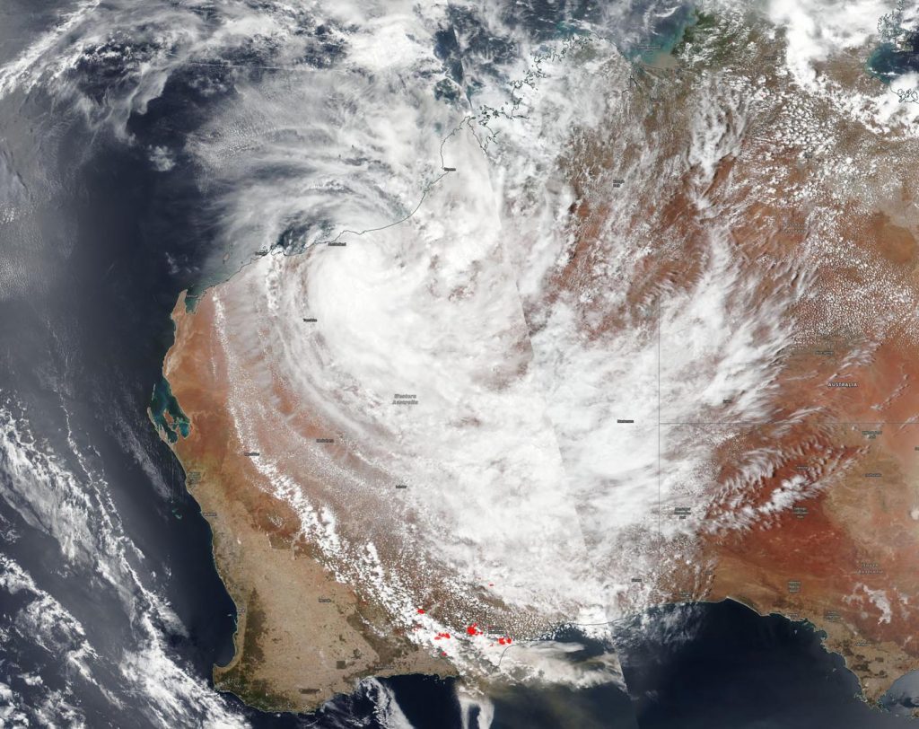
The South Interior area of the state of Western Australia is under warnings for heavy rainfall and gusty winds as the remnants of Tropical Storm Blake move on a southeasterly path through the state. Imagery from NASA-NOAA’s Suomi NPP satellite provided an image of the storm’s clouds.

Suomi NPP image of Blake
NASA-NOAA’s Suomi NPP satellite passed over Western Australia and found the remnants of former Tropical Storm Blake now in the central part of the state. Credit: NASA Worldview, Earth Observing System Data and Information System (EOSDIS)

The Visible Infrared Imaging Radiometer Suite (VIIRS) instrument aboard Suomi NPP provided a visible image of Blake’s remnants that showed the storm stretched from the South Interior to Goldfields, Southeast Coastal and Eucla localities. The strongest storms appeared in the northwestern corner of the South Interior.

At 9 a.m. EST (10 p.m. AWST Australia local time) on Jan. 9, the Australian Bureau of Meteorology noted that: “Ex-Tropical Cyclone Blake was located approximately 155 miles (250 km) southeast of Newman, or 130 miles (210 km) northeast of Wiluna, moving slowly southeast through the South Interior.”

ABM cautioned that Blake’s remnants could bring damaging winds  averaging from 31 to 37 mph (50 to 60 kph). Strongest winds are most likely near the system center. In addition to the winds, heavy rainfall may cause flooding. Expected daily rainfall totals are from 3 to 6 inches (75 mm to 150 mm) with higher isolated amounts. ABM Flood Warnings are updated at: http://www.bom.gov.au/wa/warnings/.

Tropical cyclones/hurricanes are the most powerful weather events on Earth. NASA’s expertise in space and scientific exploration contributes to essential services provided to the American people by other federal agencies, such as hurricane weather forecasting.
For updated forecasts from the ABM, visit:  http://www.bom.gov.au

By Rob Gutro 
NASA’s Goddard Space Flight Center

Blake – Southern Indian Ocean

Jan. 08, 2020 – NASA-NOAA Satellite Catches Tropical Cyclone Blake and Western Australia Fires

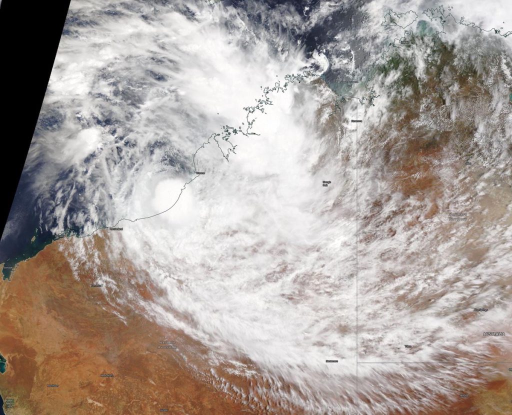
Tropical cyclone Blake made landfall in the Kimberley coast of Western Australia and NASA-NOAA’s Suomi NPP satellite provided an image that showed its center inland with the storm extending to the southern part of the state where fires raged.

Suomi NPP Image of Blake
NASA-NOAA’s Suomi NPP satellite captured an image of Tropical Storm Blake covering a good portion of Western Australia on January 8, 2020 although its center is just inland from the Kimberley coast. The red spots at the southern extent of the state indicate wildfires. The brown stream extending over the Southern Indian Ocean and into the Great Australian Bight is the smoke generated from the fires. Credit: NASA Worldview, Earth Observing System Data and Information System (EOSDIS)

On January 8, 2020, the Visible Infrared Imaging Radiometer Suite (VIIRS) instrument aboard Suomi NPP provided a visible image of Blake that showed its center was just inland from the Kimberley coast. Bands of thunderstorms stretched far south all the way to the southern coast, where fires are raging. In the VIIRS image, red spots at the southern extent of the state indicate the heat signature of wildfires burning. A brown stream extending over the Southern Indian Ocean and into the Great Australian Bight is the smoke generated from the fires.

At 10 p.m. EST on January 7 (0300 UTC on January 8) the Joint Typhoon Warning Center or JTWC in Pearl Harbor, Hawaii issued their final warning on the system. At that time, Blake was centered near latitude 20.7 degrees south and longitude 119.7 degrees east, about 66 nautical miles east-southeast of Port Hedland, Australia. Blake was moving to the southwest and had maximum sustained winds near 35 knots (40 mph).

By January 8 at 10 a.m. EST, radar from the Australian Bureau of Meteorology’s station in Kalgoorlie showed some showers in the area.

According to the website Emergency WA (Western Australia) there were fires burning south of Kalgoorlie in the Dundas Nature Reserve on January 7 at 11 p.m. EST. That fire is affecting Salmon Gums including the southern part of the Dundas Nature Reserve, Norseman, Higginsville, Widgiemooltha, Londonderry, Burra Rock, Victoria Rock and North Cascade in the Shires of Coolgardie, Dundas, Esperance and Widgiemooltha.

Blake is dissipating inland over the northwestern part of Western Australia, but generating rain that extends to the south.

Tropical cyclones and hurricanes are the most powerful weather events on Earth. NASA’s expertise in space and scientific exploration contributes to essential services provided to the American people by other federal agencies, such as hurricane weather forecasting.
By Rob Gutro 
NASA’s Goddard Space Flight Center

Blake – Southern Indian Ocean

Jan. 07, 2020 – NASA Sees Tropical Storm Blake’s Center off Australia’s Kimberley Coast

NASA’s Terra satellite passed over the Southern Indian Ocean on January 7 and found the center of Tropical Storm Blake just of the Kimberley coast of Western Australia.

Terra image of Blake
On Jan. 7, 2020, the MODIS instrument that flies aboard NASA’s Terra satellite provided a visible image of Tropical Storm Blake near the Kimberley coast of Western Australia. The MODIS image showed the extent of the southern quadrant of Blake’s clouds stretching inland into the northwestern part of Western Australia. Credit: NASA Worldview, Earth Observing System Data and Information System (EOSDIS)

The Australian Bureau of Meteorology or ABM noted that the Warning Zone for the storm stretches from Bidyadanga to De Grey, extending inland to Shay Gap.

On January 7, the Moderate Imaging Spectroradiometer or MODIS instrument that flies aboard NASA’s Terra satellite provided a visible image of Blake that showed a rounded center of circulation surrounded by strong thunderstorms. A rounded shape of a tropical cyclone indicates an organized storm. That center was located just off shore from Bidyadanga. Bidyadanga is also known as La Grange and has the largest Aboriginal community in Western Australia.

The MODIS image showed the extent of the southern quadrant of Blake’s clouds stretching inland into the northwestern part of Western Australia.

At 7 a.m. EST (1200 UTC/8 p.m. AWST local time), Blake had maximum sustained winds near 75 kph (47 mph). Blake is centered near latitude 19.1 degrees south and longitude 121.0 degrees east, about 85 kilometers (km) (53 miles) north northeast of Wallal Downs and 95 km (59 miles) west southwest of Bidyadanga. Blake is moving to the south.

ABM forecasters said that Blake is likely to track close to the west Kimberley coast this evening and cross the coast along Eighty Mile Beach near Wallal Downs early Wednesday morning, January 8. “There is a chance the system may take a more southwest track early Wednesday morning close to the coast. If this occurs, it may stay just far enough off the coast to intensify slightly further before making landfall later Wednesday morning between Wallal Downs and Pardoo Roadhouse,” according to ABM.

Tropical Cyclone Blake is moving south and is expected to make landfall near Wallal Downs early Wednesday morning, January 8.

NASA’s Terra satellite is one in a fleet of NASA satellites that provide data for hurricane research.

Tropical cyclones and hurricanes are the most powerful weather events on Earth. NASA’s expertise in space and scientific exploration contributes to essential services provided to the American people by other federal agencies, such as hurricane weather forecasting.

For updated forecasts from ABM, visit: http://www.bom.gov.au/

By Rob Gutro
NASA’s Goddard Space Flight Center

Blake – Southern Indian Ocean

January 06, 2020 – NASA Finds Heavy Rain Potential in Tropical Cyclone Blake

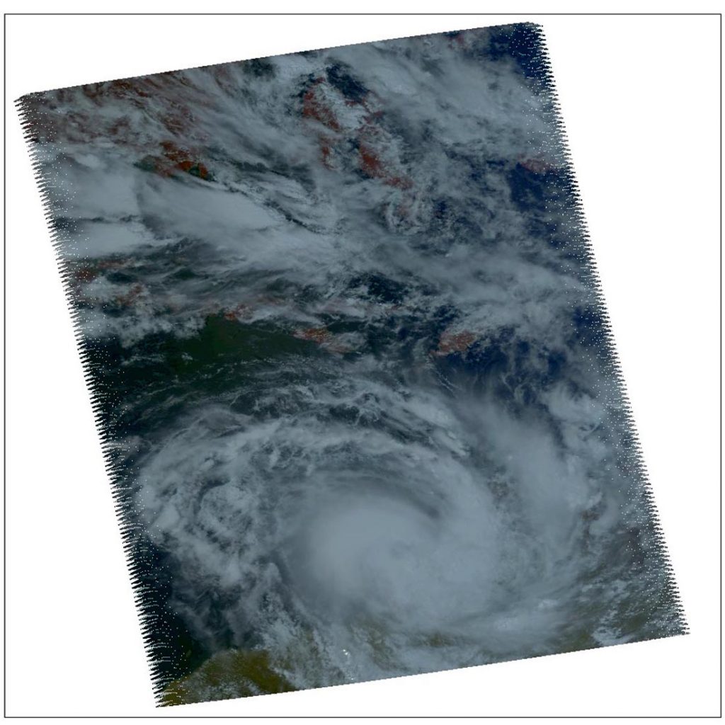
NASA’s Aqua satellite provided a near visible image and analyzed the cloud top temperatures in Tropical Cyclone Blake, located along the northern coast of Western Australia. Tropical Cyclone Blake is just north of Broome, a coastal town in the Kimberley region of Western Australia.

AIRS infrared image of Blake
On Jan. 6 at 12:35 a.m. EST (0535 UTC/1:35 p.m. AWST) NASA’s Aqua satellite analyzed Tropical Cyclone Blake’s cloud top temperatures using the AIRS instrument. AIRS showed the strongest storms contained cloud top temperatures as cold as or colder than 210 Kelvin (purple) (minus 81 degrees Fahrenheit or minus 63.1 degrees Celsius) around the center. Credit: NASA JPL/Heidar Thrastarson

On January 6, the Australian Bureau of Meteorology posted warnings and watches for Blake. The Warning zone stretches from Cockatoo Island to De Grey. The Watch zone extends from De Grey to Whim Creek, including Port Hedland and extending inland to include Marble Bar and Nullagine.

In addition, there are several community alerts in effect. A Yellow alert is in effect for residents in or near communities from Cockatoo Island to Bidyadanga, including Bidyadanga and Broome but not including Derbyd.  A Yellow alert means residents need to take action and get ready to shelter from a cyclone. A Blue alert is in effect for residents in or near communities from Bidyadanga to De Grey which means they need to prepare for cyclonic weather.

One of the ways NASA researches tropical cyclones is using infrared data that provides temperature information. Cloud top temperatures identify where the strongest storms are located. The stronger the storms, the higher they extend into the troposphere, and the colder the cloud temperatures are.

AIRS visible image of Blake
On Jan. 6 at 12:35 a.m. EST (0535 UTC/1:35 p.m. AWST) NASA’s Aqua satellite provided a near visible image of Tropical Cyclone Blake along the northern coast of Western Australia. Credit: NASA JPL/Heidar Thrastarson

On Jan. 6 at 12:35 a.m. EST (0535 UTC/1:35 p.m. AWST) NASA’s Aqua satellite analyzed Tropical Cyclone Blake’s cloud top temperatures using the Atmospheric Infrared Sounder or AIRS instrument. AIRS showed the strongest storms contained cloud top temperatures as cold as or colder than 210 Kelvin (minus 81 degrees Fahrenheit/minus 63.1 degrees Celsius) around the center. NASA research has shown that cloud top temperatures that cold indicate strong storms that have the capability to create heavy rain.

Tropical cyclones do not always have uniform strength, and some sides are stronger than others, so knowing where the strongest sides of the storms are located helps forecasters. NASA then provides data to tropical cyclone meteorologists so they can incorporate it in their forecasts. Satellite data has shown that the strongest storms associated with the system are currently confined to the southwestern portion of the circulation, and the Joint Typhoon Warning Center noted the low-level circulation remains robust.

On January 6 at 10 a.m. EST (1500 UTC), the Joint Typhoon Warning Center noted that Blake has maximum sustained winds near 50 knots (48 mph/93 kph). Forecasters believe that Blake has peaked in intensity and after today,  will begin a weakening trend. Blake was centered near latitude 17.7 degrees south and longitude 121.9 degrees east, approximately 32 nautical miles north-northwest of Broome, Australia. Blake has tracked south-southwestward and is forecast to continue moving in that general direction.

Forecasters at JTWC anticipate landfall to the east of Port Hedland between 24 and 26 hours (from Jan. 6 at 10 a.m. EST/1500 UTC). After landfall, the system is expected to continue moving inland and slowly dissipate by 72 hours.

Tropical cyclones and hurricanes are the most powerful weather events on Earth. NASA’s expertise in space and scientific exploration contributes to essential services provided to the American people by other federal agencies, such as hurricane weather forecasting.
The AIRS instrument is one of six instruments flying on board NASA’s Aqua satellite, launched on May 4, 2002.

By Rob Gutro
NASA’s Goddard Space Flight Center