Dolphin – Northwestern Pacific Ocean

Sep. 24, 2020 – NASA Nets Dolphin as an Extratropical Storm

NASA’s Aqua satellite caught a visible image of Dolphin after it passed east central Japan on Sept. 24, where it became an extratropical storm in the Northwestern Pacific Ocean.

Aqua image of Dolphin
NASA’s Aqua satellite provided a visible image of Extratropical Storm Dolphin in the Northwestern Pacific Ocean at 11:35 p.m. EDT on Sept. 23 (0335 UTC on Sept. 24). Image Courtesy: NASA Worldview, Earth Observing System Data and Information System (EOSDIS).

At 11 p.m. EDT on Sept. 23 (0300 UTC on Sept. 24) the Joint Typhoon Warning Center (JTWC) noted, “Animated multispectral satellite imagery shows the ragged low level circulation has become quasi-stationary and fully exposed as the rapidly decaying central convection sheared 140 plus nautical miles to the east-northeast. Analysis indicates that tropical cyclone Dolphin now fully embedded in the baroclinic zone and has become extra-tropical.”

Strong vertical wind shear from the west-southwest was battering Dolphin and pushing the bulk of clouds to the east-northeast. Wind shear occurs when winds outside of a tropical cyclone blow against it and adversely affect its circulation by displacing clouds and precipitation and weakening the system.

Dolphin on Sept. 24

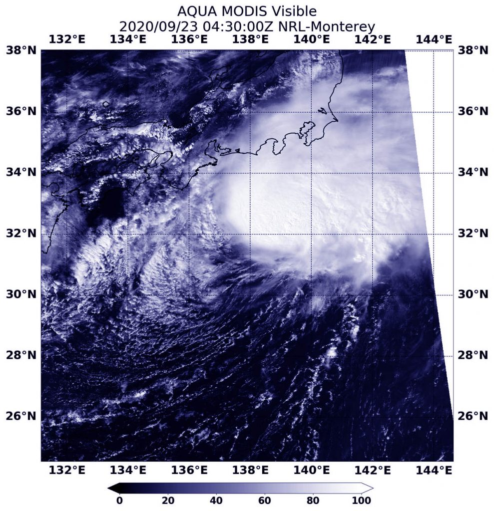
At 11 p.m. EDT on Sept. 23 (0300 UTC on Sept. 24) the center of Dolphin was located near latitude 33.1 degrees north and longitude 141.8 degrees east. That is about 175 nautical miles southeast of Yokosuka, Japan. Dolphin was barely moving to the south at 1 knot and had maximum sustained winds near 30 knots (35 mph/55 kph).

NASA’s Aqua Satellite View

The Moderate Resolution Imaging Spectroradiometer or MODIS instrument that flies aboard NASA’s Aqua satellite captured a visible image of Dolphin at 11:35 p.m. EDT on Sept. 23 (0335 UTC on Sept. 24). The image showed the storm appeared more elongated. That is an indication that the storm was weakening and it had become extratropical.

What is an Extra-tropical Storm?

Often, a tropical cyclone will transform into an extra-tropical cyclone as it recurves toward the poles (north or south, depending on the hemisphere the storm is located in). An extra-tropical cyclone is a storm system that primarily gets its energy from the horizontal temperature contrasts that exist in the atmosphere.

Tropical cyclones have their strongest winds near the earth’s surface, while extra-tropical cyclones have their strongest winds near the tropopause – about eight miles (12 km) up. Also, tropical cyclones, in contrast, typically have little to no temperature differences across the storm at the surface and their winds are derived from the release of energy due to cloud/rain formation from the warm moist air of the tropics.

Dolphin’s Final Forecast  

Forecasters at the JTWC noted, “The remnant storm-force cold-core low [pressure area] will drift slowly poleward [north] and deeper into the cold polar air mass. There is also a distinct possibility that the cyclone will remain quasi-stationary and dissipate.”

About NASA’s Worldview and Aqua Satellite

NASA’s Earth Observing System Data and Information System (EOSDIS) Worldview application provides the capability to interactively browse over 700 global, full-resolution satellite imagery layers and then download the underlying data. Many of the available imagery layers are updated within three hours of observation, essentially showing the entire Earth as it looks “right now.”

NASA’s Aqua satellite is one in a fleet of NASA satellites that provide data for hurricane research.

Hurricanes/tropical cyclones are the most powerful weather events on Earth. NASA’s expertise in space and scientific exploration contributes to essential services provided to the American people by other federal agencies, such as hurricane weather forecasting.

By Rob Gutro
NASA’s Goddard Space Flight Center

Dolphin – Northwestern Pacific Ocean

Sep. 23, 2020 – NASA Finds Dolphin Swimming Against Wind Shear

NASA’s Terra satellite provided a visible image of a slightly elongated Tropical Storm Dolphin as it battled wind shear upon its approach to east central Japan.

Terra image of Dolphin
On Sept. 23, NASA’s Terra satellite provided a visible image of Tropical Storm Dolphin approaching east central Japan. Image Courtesy: NASA/NRL

A Visible Satellite Image

The Moderate Resolution Imaging Spectroradiometer or MODIS instrument that flies aboard NASA’s Terra satellite captured a visible image of Tropical Storm Dolphin on Sept. 23 at 12:30 a.m. EDT (0430 UTC). Dolphin appeared somewhat elongated from west to east likely from the strong vertical wind shear the storm has been battling.

However, despite the increasing vertical wind shear of 30 knots (35 mph/56 kph), animated multispectral satellite imagery shows that Dolphin is a consolidated system with strong thunderstorms banding and wrapping into the low-level circulation center.

Wind Shear Affecting Dolphin

The shape of a tropical cyclone provides forecasters with an idea of its organization and strength. When outside winds batter a storm, it can change the storm’s shape. Winds can push most of the associated clouds and rain to one side of a storm.

In general, wind shear is a measure of how the speed and direction of winds change with altitude. Tropical cyclones are like rotating cylinders of winds. Each level needs to be stacked on top each other vertically in order for the storm to maintain strength or intensify. Wind shear occurs when winds at different levels of the atmosphere push against the rotating cylinder of winds, weakening the rotation by pushing it apart at different levels.

Dolphin on Sept. 23

On Sept. 23 at 5 a.m. EDT (0900 UTC). Tropical Storm Dolphin was located near latitude 32.0 degrees north and longitude 138.6 degrees east. That is about 205 nautical miles south-southwest of Yokosuka, Japan. Dolphin was moving to the northeast and had maximum sustained winds of 50 knots (58 mph/92 kph).

Dolphin is forecast to move northeast and will gradually weaken before becoming extra-tropical near Tokyo.

NASA Researches Tropical Cyclones

Hurricanes/tropical cyclones are the most powerful weather events on Earth. NASA’s expertise in space and scientific exploration contributes to essential services provided to the American people by other federal agencies, such as hurricane weather forecasting.

NASA’s Terra satellite is one in a fleet of NASA satellites that provide data for hurricane research.

For more than five decades, NASA has used the vantage point of space to understand and explore our home planet, improve lives and safeguard our future. NASA brings together technology, science, and unique global Earth observations to provide societal benefits and strengthen our nation. Advancing knowledge of our home planet contributes directly to America’s leadership in space and scientific exploration.

For forecast updates on hurricanes, visit: www.hurricanes.gov

By Rob Gutro
NASA’s Goddard Space Flight Center

Dolphin – Northwestern Pacific Ocean

Sep. 22, 2020 – NASA Catches Tropical Storm Dolphin Swimming North   

NASA’s Terra satellite obtained visible imagery of Tropical Storm Dolphin as it continued moving north though the Northwestern Pacific Ocean on a track toward east central Japan.

Terra image of Dolphin
On Sept. 22, 2020, NASA’s Terra satellite provided a visible image of Tropical Storm Dolphin as it continued moving north through the Northwestern Pacific Ocean. Credit: NASA/NRL

NASA Satellite View: Dolphin’s Organization

The Moderate Resolution Imaging Spectroradiometer or MODIS instrument that flies aboard NASA’s Terra satellite captured a visible image of Tropical Storm Dolphin on Sept. 22 at 0345 UTC (Sept. 21 at 11:45 p.m. EDT). The visible image revealed strong storms around the low-level center of circulation with bands of thunderstorms in the northeastern quadrant. Microwave satellite imagery revealed an eye feature.

The Joint Typhoon Warning Center noted that another satellite image indicates that the upper-level circulation center is tilted about 30 nautical miles east of the low-level center due to increasing westerly vertical wind shear.

NASA’s Terra satellite is one in a fleet of NASA satellites that provide data for hurricane research.

Dolphin on Sept. 22

At 5 a.m. EDT (0900 UTC) on Sept. 22 Tropical storm Dolphin was located near latitude 27.9 degrees north and longitude 135.5 degrees east, about 493 nautical miles south-southwest of Yokosuka, Japan. Dolphin was moving to the north and had maximum sustained winds 60 knots (69 mph/111 kph).

Dolphin will move north, later turning to the northeast. It is expected to weaken gradually before becoming extra-tropical near Tokyo.

NASA Researches Earth from Space

For more than five decades, NASA has used the vantage point of space to understand and explore our home planet, improve lives and safeguard our future. NASA brings together technology, science, and unique global Earth observations to provide societal benefits and strengthen our nation. Advancing knowledge of our home planet contributes directly to America’s leadership in space and scientific exploration.

By Rob Gutro
NASA’s Goddard Space Flight Center


Dolphin – Northwestern Pacific Ocean

Sep. 21, 2020 – NASA Finds Tropical Storm Dolphin Going Swimmingly

NASA’s Terra satellite obtained visible imagery of recently formed Tropical Depression 14W as it strengthened into a tropical storm. Terra satellite imagery showed the storm was organizing.

Terra image of Dolphin
NASA’s Terra satellite provided a visible image to forecasters of Tropical Storm Dolphin on Sept. 21. The imagery showed the storm was consolidating and organizing. Image Courtesy: NASA Worldview, Earth Observing System Data and Information System (EOSDIS).

Dolphin developed from Tropical Depression 14W. 14W formed on Sept. 20 about 366 miles east-southeast of Kadena Air Base, Okinawa Island, Japan. By 5 a.m. EDT (0900 UTC) on Sept. 21, the storm organized and strengthened into a tropical storm.

NASA Satellite View: Dolphin’s Organization

The Moderate Resolution Imaging Spectroradiometer or MODIS instrument that flies aboard NASA’s Terra satellite captured a visible image of Tropical Storm Dolphin on Sept. 21. Satellite imagery revealed a persistent deep convection and development of thunderstorms wrapping into a low-level circulation center. That is an indication of consolidation and better organization.

The satellite image was created using NASA’s Worldview product at NASA’s Goddard Space Flight Center in Greenbelt, Md.

Tropical Storm Dolphin on Sept. 21

Tropical storm Dolphin was located about 625 nautical miles south-southwest of Yokosuka, Japan, near latitude 25.7 degrees north and longitude 135.0 degrees east. It was moving slowly to the north-northeast at 4 knots and had maximum sustained winds 45 knots (52 mph/83 kph).  

 Dolphin’s Forecast and Track  

The Joint Typhoon Warning Center (JTWC) forecasts that Dolphin will move north. Then later it is expect to turn to the northeast and strengthen to 55 knots.

JTWC forecasters expect the system to take on additional subtropical characteristics as it moves into an area of decreasing sea surface temperatures and increasing vertical wind shear. The storm’s upper level outflow is also expected to become more strongly associated with the robust westerly wind flow associated with the jet stream. By 11 a.m. EDT (1500 UTC) on Sept. 22, the system will begin extratropical transition and will complete that transition to the south of Japan.

About NASA’s Worldview and Terra Satellite

NASA’s Earth Observing System Data and Information System (EOSDIS) Worldview application provides the capability to interactively browse over 700 global, full-resolution satellite imagery layers and then download the underlying data. Many of the available imagery layers are updated within three hours of observation, essentially showing the entire Earth as it looks “right now.”

NASA’s Terra satellite is one in a fleet of NASA satellites that provide data for hurricane research.

Tropical cyclones/hurricanes are the most powerful weather events on Earth. NASA’s expertise in space and scientific exploration contributes to essential services provided to the American people by other federal agencies, such as hurricane weather forecasting.

By Rob Gutro
NASA’s Goddard Space Flight Center