Francisco – Northwestern Pacific Ocean

Aug. 07, 2019 – NASA Catches Transitioning Tropical Storm Francisco near Korean Peninsula

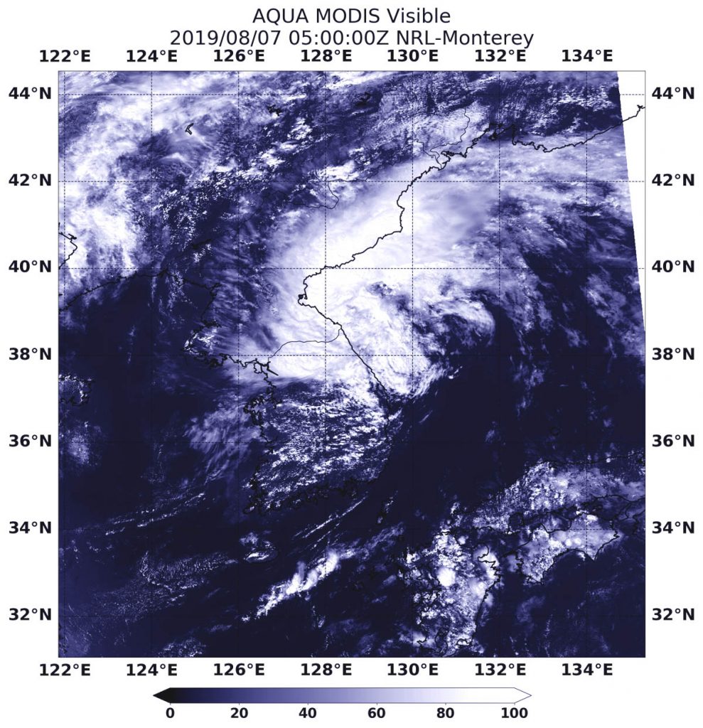
NASA’s Aqua satellite passed over the Sea of Japan and provided forecasters with a visible image of Tropical Storm Francisco as it was transitioning into an extra-tropical cyclone.
Aqua image of Francisco
On Aug. 7, 2019 at 1:00 a.m. EDT (0500 UTC), the MODIS instrument aboard NASA’s Aqua satellite provided a visible image of Tropical Storm Francisco in the Sea of Japan, along the Korean Peninsula. Credit: NASA/NRL

Often, a tropical cyclone will transform into an extra-tropical cyclone as it recurves toward the poles (north or south, depending on the hemisphere the storm is located in). An extra-tropical cyclone is a storm system that primarily gets its energy from the horizontal temperature contrasts that exist in the atmosphere. Extra-tropical cyclones (also known as mid-latitude or baroclinic storms) are low pressure systems with associated cold fronts, warm fronts, and occluded fronts.

Tropical cyclones, in contrast, typically have little to no temperature differences across the storm at the surface and their winds are derived from the release of energy due to cloud/rain formation from the warm moist air of the tropics. Structurally, tropical cyclones have their strongest winds near the earth’s surface, while extra-tropical cyclones have their strongest winds near the tropopause – about 8 miles (12 km) up.

On Aug. 7, 2019 at 1:00 a.m. EDT (0500 UTC), the Moderate Resolution Imaging Spectroradiometer or MODIS instrument aboard NASA’s Aqua satellite provided a visible image of Francisco that showed it was still along the coast of the Korean Peninsula. It also appeared elongated from south to north.

At 5 a.m. EDT (0900 UTC), the Joint Typhoon Warning Center issued the final warning on Francisco. Maximum sustained winds dropped to near 35 knots (40 mph/65 kph). It was centered near 39.6 degrees north latitude and 129.3 degrees east longitude. That is 166 nautical miles northeast of Seoul, South Korea. Francisco was moving to the northeast.

The Joint Typhoon Warning Center noted that Francisco will traverse the Sea of Japan and move over Hokkaido while weakening.

By Rob Gutro
NASA’s Goddard Space Flight Center

Francisco – Northwestern Pacific Ocean

Aug. 06, 2019 – NASA Finds Tropical Storm Francisco in the Korea Strait

NASA’s Aqua satellite passed over the Korea Strait and found the center of Tropical Storm Francisco in the middle of it. The AIRS instrument aboard took the temperature of its cloud tops to estimate storm strength and found strong storms over two countries.

AIRS image of Francisco
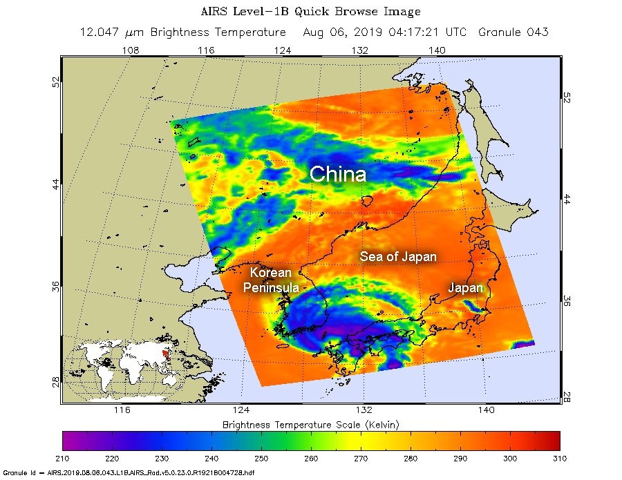
On Aug. 6, at 1217 a.m. EDT (0417 UTC). the AIRS instrument aboard NASA’s Aqua satellite analyzed cloud top temperatures of Tropical Storm Francisco in infrared light. AIRS found coldest cloud top temperatures (purple) of strongest thunderstorms were as cold as or colder than minus 63 degrees Fahrenheit (minus 53 degrees Celsius). Credit: NASA JPL/Heidar Thrastarson

The Korea Strait is a located between South Korea and Japan. It connects the East China Sea, the Yellow Sea and the Sea of Japan in the northwest Pacific Ocean.

NASA’s Aqua satellite passed over Francisco on Aug. 6, at 1217 a.m. EDT (0417 UTC). The Atmospheric Infrared Sounder or AIRS instrument aboard NASA’s Aqua satellite analyzed Francisco in infrared light and found cloud top temperatures of strongest thunderstorms as cold as or colder than minus 63 degrees Fahrenheit (minus 53 degrees Celsius) were wrapping around the low-level center from west to north to east. Cloud top temperatures that cold indicate strong storms that have the capability to create heavy rain. Those strong storms were affecting southern South Korea and southern Japan. The southern side of the storm appeared to have few storms.

At 11 a.m. EDT (1500 UTC), the center of Tropical Storm Francisco was located near latitude 36.2 degrees north and 129.4 degrees east longitude. Francisco’s center is about 33 nautical miles north-northeast of Busan, South Korea. It was moving to the northwest and had maximum sustained winds near 45 knots (52 mph/83 kph).

The Joint Typhoon Warning Center forecasts that Francisco will move north then turn northeast and curve east through the Sea of Japan and cross Hokkiado, the northernmost islands of Japan on Aug. 8.

By Rob Gutro
NASA’s Goddard Space Flight Center

Francisco – Northwestern Pacific Ocean

Aug. 05, 2019 – NASA Catches Tropical Storm Francisco’s Approach to Landfall in Southern Japan

Infrared imagery from NASA’s Aqua satellite shows that Tropical Storm Francisco had powerful thunderstorms with heavy rain capabilities around the center of circulation as it moves toward landfall in southern Japan.

Terra image of Francisco
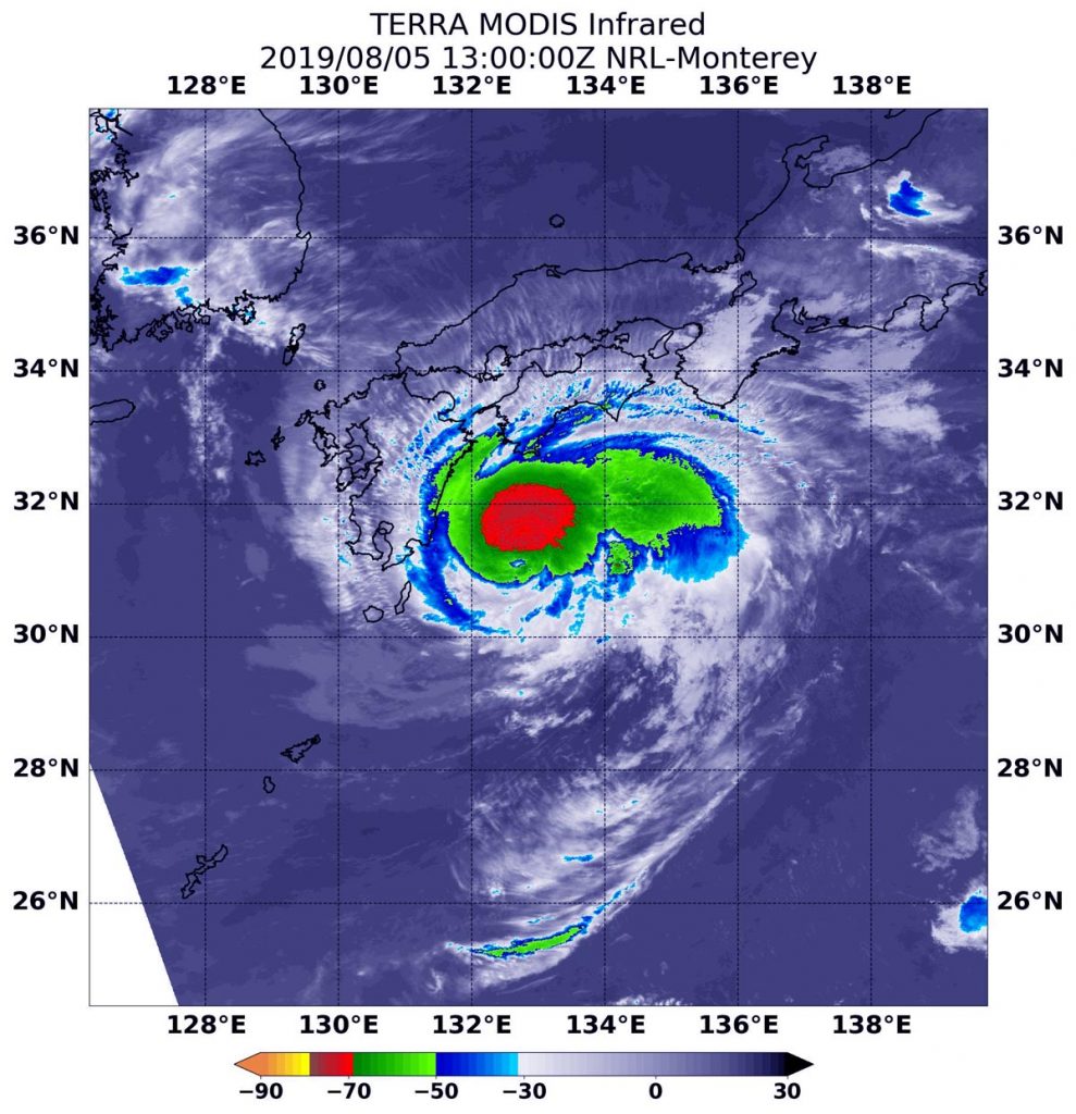
On Aug. 5 at 9 a.m. EDT (1300 UTC) the MODIS instrument that flies aboard NASA’s Aqua satellite showed strongest storms (red) in Tropical Storm Francisco circled the center. There, cloud top temperatures were as cold as minus 70 degrees Fahrenheit (minus 56.6 Celsius). Credit: NASA/NRL

On Aug. 5, 2019, the Japan Meteorological Agency has issued warnings for the Amami, Kyushu and Shikoku. Advisories are in effect for Chugoku, Kinki Ogasawara, Okinawa and Tokai.

NASA’s Aqua satellite used infrared light to analyze the strength of storms in Tropical Storm Francisco and found strongest storms circling the center. Infrared data provides temperature information, and the strongest thunderstorms that reach high into the atmosphere have the coldest cloud top temperatures.

On Aug. 5 at 9 a.m. EDT (1300 UTC), the Moderate Imaging Spectroradiometer or MODIS instrument that flies aboard NASA’s Aqua satellite  found strongest thunderstorms had cloud top temperatures as cold as minus 70 degrees Fahrenheit (minus 56.6 Celsius). Cloud top temperatures that cold indicate strong storms with the potential to generate heavy rainfall.

Microwave satellite imagery revealed an eye had formed in the center of those powerful thunderstorms.

The Joint Typhoon Warning Center or JTWC noted at 11 a.m. EDT (1500 UTC) that Francisco had maximum sustained winds near 60 knots (60 mph/111kph). Francisco was centered near 31.6 degrees north latitude and 132.4 degrees east longitude. Tropical storm Francisco was located approximately 203 nautical miles east-southeast of Sasebo, Japan. Francisco has tracked westward.

After the storm makes landfall in Kyushu, Japan, it is forecast to pass into the south of the Korean peninsula, and turn to the northeast as it becomes extra-tropical over the Sea of Japan.

For updated warnings from the Japan Meteorological Agency, visit: https://www.jma.go.jp/en/warn/

By Rob Gutro
NASA’s Goddard Space Flight Center

Francisco – Northwestern Pacific Ocean

Aug. 02, 2019 – NASA Catches Birth of Northwestern Pacific’s Tropical Storm Francisco

Soon after Tropical Storm Francisco developed in the Northwestern Pacific Ocean NASA’s Terra satellite passed overhead.

Terra image of Francisco
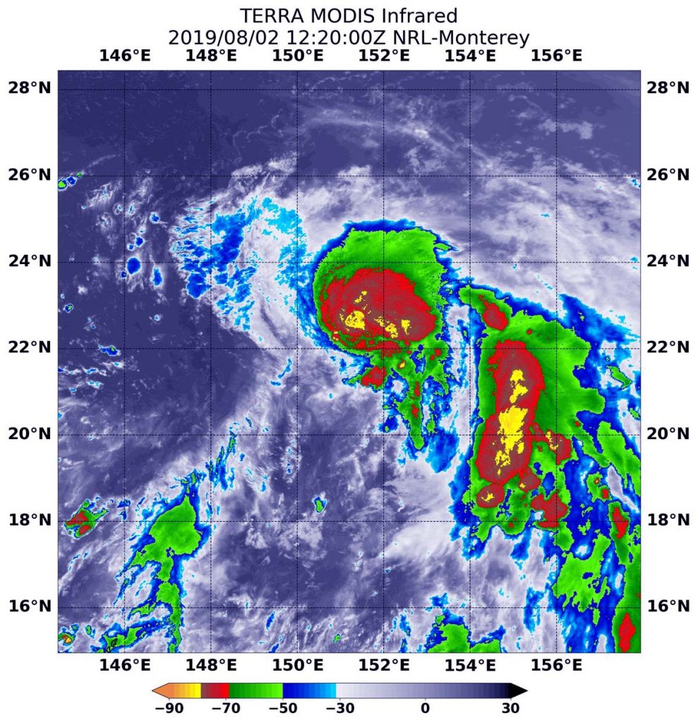
On August 2 at 8:20 a.m. EDT (1220 UTC) the MODIS instrument that flies aboard NASA’s Terra satellite showed strongest storms (yellow) in Tropical Storm Francisco around the center and in fragmented bands of thunderstorms circling the center, where cloud top temperatures were as cold as minus 80 degrees Fahrenheit (minus 62.2 Celsius). Credit: NASA/NRL

NASA’s Terra satellite used infrared light to gather temperature information from newly developed Tropical Storm Francisco. The strongest thunderstorms reach high into the atmosphere and have the coldest cloud top temperatures.

On August 2 at 8:20 a.m. EDT (1220 UTC) the Moderate Imaging Spectroradiometer or MODIS instrument that flies aboard NASA’s Terra satellite found coldest cloud top temperatures as cold as minus 80 degrees Fahrenheit (minus 62.2 Celsius). Cloud top temperatures that cold indicate strong storms with the potential to generate heavy rainfall. Those strongest storms were seen around the center and in fragmented bands of thunderstorms circling the center. Those temperatures were also found in a large band of thunderstorms feeding into the center from the east.

At 11 a.m. EDT (1500 UTC), the center of Tropical Storm Francisco was located near latitude 21.7 degrees north and longitude 151.2 degrees east. That’s about 576 nautical miles east-southeast of Iwo To island, Japan. Francisco is moving toward the northwest. Maximum sustained winds are near 40 knots (46 mph/74 kph) with higher gusts.

On the forecast track, the Joint Typhoon Warning Center forecasts Francisco to move northwest toward southwestern Japan. Francisco is expected to strengthen to 85 knots (98 mph/157 kph) before landfall in Kyushu by August 6, and a second landfall the next day in South Korea.

By Rob Gutro
NASA’s Goddard Space Flight Center