Gaja (Southern Indian Ocean)

November 16, 2018 – NASA Catches Tropical Cyclone Gaja’s Landfall

Caught in the act of landfall, Tropical Cyclone Gaja was seen by NASA’s Aqua satellite as it passed overhead and collected temperature information.
AIRS image of Gaja
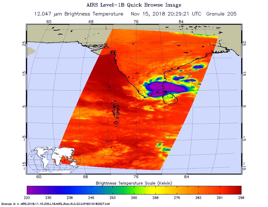
NASA’s Aqua satellite provided an infrared picture of Tropical Cyclone Gaja’s cloud top temperatures from Nov. 15 at 3:29 p.m. EDT (2029 UTC). Gaja’s center was making landfall along the coast of southeastern India. Coldest clouds tops and strongest storms appear in purple. Credit: NASA JPL, Heidar Thrastarson

The Atmospheric Infrared Sounder or AIRS instrument aboard NASA’s Aqua satellite passed over Tropical Cyclone Gaja on Nov. 15 at 3:29 p.m. EDT (2029 UTC) and analyzed the storm in infrared light. Infrared light provides temperature data and that’s important when trying to understand how strong storms can be. The higher the cloud tops, the colder and the stronger they are.

When Aqua passed over the Indian Ocean, Gaja’s center was making landfall along the coast of southeastern India. The AIRS instrument found coldest cloud top temperatures in thunderstorms around the center, where temperatures were as cold as minus 63 degrees Fahrenheit (minus 53 degrees Celsius). Storms with cloud top temperatures that cold have the capability to produce heavy rainfall.

At 10 a.m. EST (1500 UTC), the center of Tropical Cyclone Gaja was located near latitude 9.7 degrees north and longitude 75.9 degrees west. Gaja was moving toward west-southwest. Maximum sustained winds are near 46 mph (40 knots/74 kph) with higher gusts.

Gaja was exiting the southwestern coast of India on Nov. 16 at 7 a.m. EST (1200 UTC) and was moving into the Arabian Sea where it is expected to maintain strength and travel in a westerly direction over the next several days.

By Rob Gutro
NASA’s Goddard Space Flight Center

Gaja (Southern Indian Ocean)

Nov. 15, 2018 – NASA Finds a Cloud-Filled Eye in Tropical Cyclone Gaja

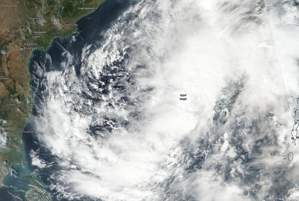
Tropical Cyclone Gaja continued to organize in the Bay of Bengal as it made its approach to southeastern India when NASA-NOAA’s Suomi NPP satellite passed overhead and captured an image. The image revealed that Gaja had developed a cloud-filled eye.

Suomi NPP image of Gaja
On Nov. 15, the VIIRS instrument aboard NASA-NOAA’s Suomi NPP satellite captured a visible image of Tropical Storm Gaja in the Bay of Bengal approaching southern India (left). Credit: NASA Worldview, Earth Observing System Data and Information System (EOSDIS)

The Bay of Bengal is in the Northern Indian Ocean basin, east of India.

On Nov. 15, the Visible Infrared Imaging Radiometer Suite (VIIRS) instrument aboard NASA-NOAA’s Suomi NPP satellite took a visible light image of Tropical Storm Gaja. It revealed what appeared to be a cloud-filled eye. The Joint Typhoon Warning Center confirmed that “animated multispectral satellite imagery shows a more compact system with a dimple feature on the central convection – indicative of a formative eye.”

On Nov. 15 at 10 a.m. EDT (1500 UTC) Gaja’s maximum sustained winds were near 55 knots (63 mph/102 kph), but weakening is expected as it nears the coast of southeastern India. Gaja was located near 10.8 degrees north latitude 80.7 east longitude. It was about 145 nautical miles south-southeast of Chennai, India.

The Joint Typhoon Warning Center or JWTC noted that Gaja will move west-southwest and is approaching landfall near Cuddalore before Nov. 16 at 4 a.m. EDT (0900 UTC). After crossing southern India, the storm will re-strengthen in the Arabian Sea, before dissipating after 5 days.

By Rob Gutro
NASA’s Goddard Space Flight Center

Gaja (Southern Indian Ocean)

Nov. 14, 2018 – Tropical Cyclone Gaja Approaching Southeastern India

Tropical Cyclone Gaja continued to track toward a landfall in southeastern India when NASA-NOAA’s Suomi NPP satellite flew over the Bay of Bengal and provided a visible image of the storm.

Suomi NPP image of Gaja
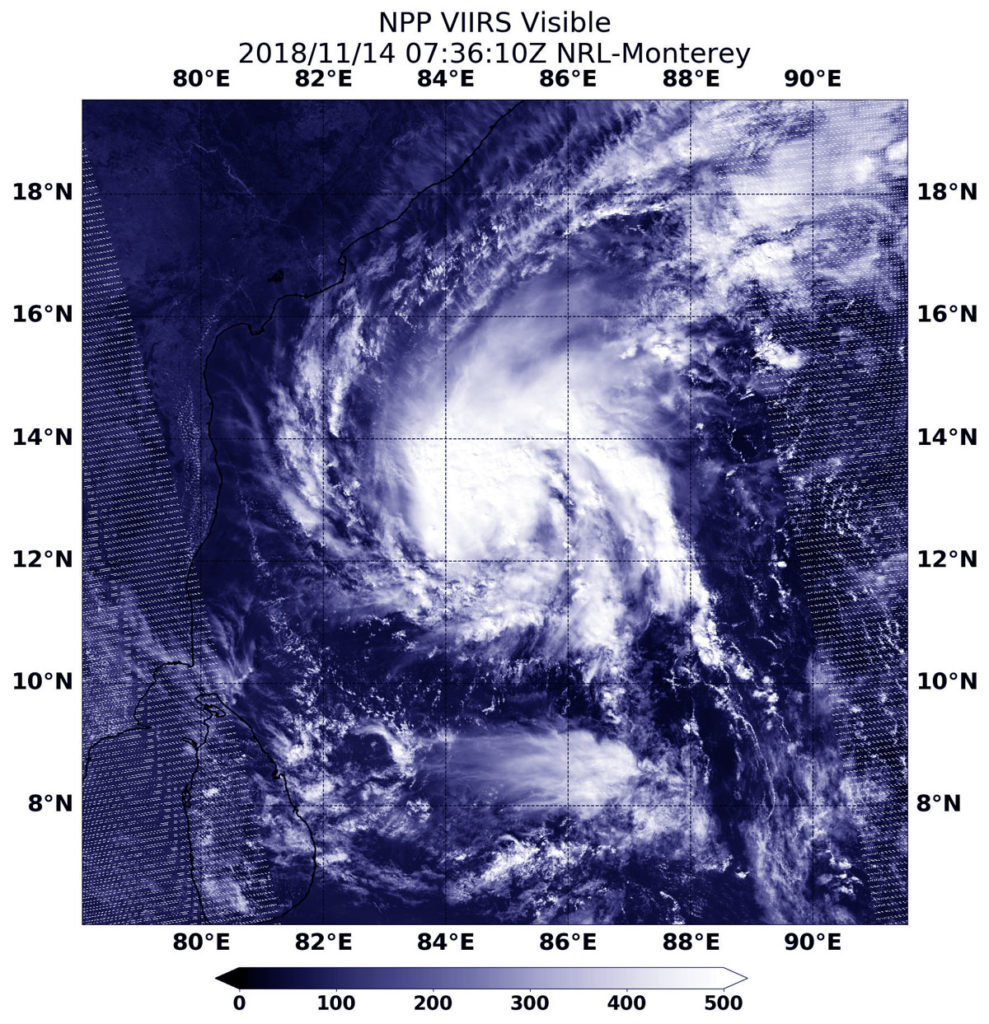
NASA-NOAA’s Suomi NPP satellite passed over the Northern Indian Ocean and captured a visible image of Tropical Cyclone Gaja approaching the southeastern coast of India at 2:36 a.m. EDT (0736 UTC) on Nov. 14, 2018. Credit: NASA/NOAA/NRL

Suomi NPP passed over Gaja on Nov. 14 at 2:36 a.m. EDT (0736 UTC) and the VIIRS instrument provided a visible image. The VIIRS image showed Gaja appeared more organized than the previous day as powerful thunderstorms circled the center. A thick band of thunderstorms wrapped into the low level center from the eastern quadrant.

At 4 a.m. EDT (0900 UTC) Tropical Cyclone Gaja was located near 12.6 degrees north latitude and 84.5 degrees east longitude. That’s about 623 nautical miles south-southwest of Calcutta, India. Gaja is moving to the west-southwest and has maximum sustained winds near 45 knots (52 mph/83 kph).

The Regional Specialized Meteorological Center for Tropical Cyclones over the Northern Indian Ocean or RSMC has issued a tropical storm warning for southern India. For updates visit: http://www.rsmcnewdelhi.imd.gov.in/index.php?lang=en

The Joint Typhoon Warning Center or JTWC forecasters expect Gaja to track over the southern Indian Peninsula, where may likely hold together and reach the Arabian Sea.

By Rob Gutro 
NASA’s Goddard Space Flight Center
Gaja (Southern Indian Ocean)

Nov. 13, 2018 – NASA-NOAA Satellite Finds a Large Tropical Cyclone Gaja

NASA-NOAA’s Suomi NPP satellite passed over the Bay of Bengal, Northern Indian Ocean and captured a visible image of Tropical Cyclone Gaja.

Suomi NPP Image of Gaja
On Nov.13, the VIIRS instrument aboard NASA-NOAA’s Suomi NPP satellite captured a visible image of Tropical Cyclone Gaja in the Northern Indian Ocean. Credit: NASA Worldview, Earth Observing System Data and Information System (EOSDIS)

Gaja formed on Nov. 10 at 4 p.m. EST (2100 UTC) as tropical cyclone 07B, about 569 miles south-southwest of Chittagong, Bangladesh. It strengthened into a tropical storm and was renamed Gaja.

On Nov. 13, the Visible Infrared Imaging Radiometer Suite (VIIRS) instrument aboard NASA-NOAA’s Suomi NPP satellite gathered data on Tropical Cyclone Gaja. Gaja appeared somewhat elongated and had bands of thunderstorms wrapping into the center. Gaja appeared to extend over much of the Bay of Bengal in satellite imagery.

The Joint Typhoon Warning Center or JTWC noted “animated multispectral satellite imagery shows expansive but disorganized and fragmented rain bands loosely wrapping into an obscured low level circulation with the deep central convection sheared northeastward.”

On Nov., 13 at 10 a.m. EST (1500 UTC) Gaja’s maximum sustained winds were near 40 mph (35 knots/62 kph). It was located approximately 320 nautical miles east of Chennai, India near 13.4 degrees north latitude and 85.6 degrees east longitude. Gaja was moving west-southwest.

JTWC forecasters expect a slow intensification, peaking at 50 knots (57.5 mph/92.6 kph) by landfall in southern India just south of Chennai on Nov. 15.

By Rob Gutro
NASA’s Goddard Space Flight Center