Hagupit – Northwestern Pacific Ocean

Aug. 04, 2020 – NASA Infrared Imagery Shows Hagupit Nearing Landfall in China

NASA’s Aqua satellite provided a look at Typhoon Hagupit as it was nearing landfall in southeastern China.
AIRS image of Hagupit
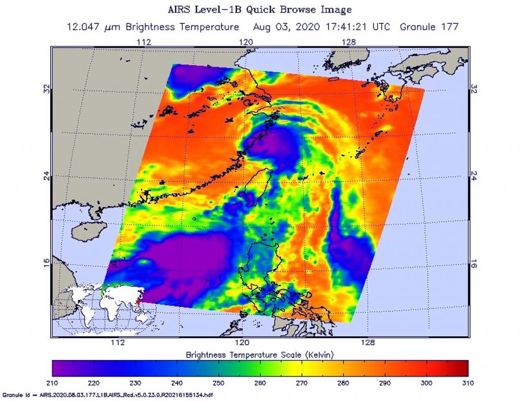
On Aug. 3 at 1:41 p.m. EDT (1741 UTC) NASA’s Aqua satellite analyzed Typhoon Hagupit less than 2 hours before landfall in China. Using the Atmospheric Infrared Sounder or AIRS instrument, NASA found coldest cloud top temperatures as cold as or colder than (purple) minus 63 degrees Fahrenheit (minus 53 degrees Celsius). Credit: NASA JPL/Heidar Thrastarson

One of the ways NASA researches tropical cyclones is using infrared data that provides temperature information. Cloud top temperatures provide information to forecasters about where the strongest storms are located within a tropical cyclone. Tropical cyclones do not always have uniform strength, and some sides have stronger sides than others. The stronger the storms, the higher they extend into the troposphere, and the colder the cloud temperatures.

On Aug. 3 at 1:41 p.m. EDT (1741 UTC) NASA’s Aqua satellite analyzed Hagupit using the Atmospheric Infrared Sounder or AIRS instrument. Aqua passed over Hagupit less than 2 hours before its official landfall.

The infrared data showed the bulk of the storms were southeast of the center because of vertical wind shear or outside winds pushing against the storm from the northwest.

AIRS found coldest cloud top temperatures as cold as or colder than minus 63 degrees Fahrenheit (minus 53 degrees Celsius). NASA research has shown that cloud top temperatures that cold indicate strong storms that have the capability to create heavy rain.

China’s National Meteorological Center reported that Hagupit made landfall China’s Zhejiang province on the coastal areas of Yueqing City at around 3:30 a.m. local time on Aug. 4 (3:30 p.m. EDT on Aug 3). At the time of landfall, Hagupit had maximum sustained winds near 85 mph (137 kph), equivalent to a Category 1 hurricane.

At 5 a.m. EDT (0900 UTC) on Aug. 4, the Joint Typhoon Warning Center noted that Tropical depression Hagupit was centered near latitude 29.8 degrees north and longitude 120.3 degrees east, about 104 nautical miles southwest of Shanghai, China. Hagupit was moving to the north with maximum sustained winds decreasing to 30 knots (35 mph/56 kph).

Hagupit is moving inland over eastern China and the Joint Typhoon Warning Center forecasts that it will reemerge into the Yellow Sea on Aug. 5, but adverse conditions will lead to Hagupit’s dissipation.

The AIRS instrument is one of six instruments flying on board NASA’s Aqua satellite, launched on May 4, 2002.

For more than five decades, NASA has used the vantage point of space to understand and explore our home planet, improve lives and safeguard our future. NASA brings together technology, science, and unique global Earth observations to provide societal benefits and strengthen our nation. Advancing knowledge of our home planet contributes directly to America’s leadership in space and scientific exploration.

For updated forecasts, visit: www.nhc.noaa.gov

By Rob Gutro
NASA’s Goddard Space Flight Center  

Hagupit – Northwestern Pacific Ocean

Aug. 03, 2020 – NASA Finds an Eye and a Giant “Tail” in Typhoon Hagupit

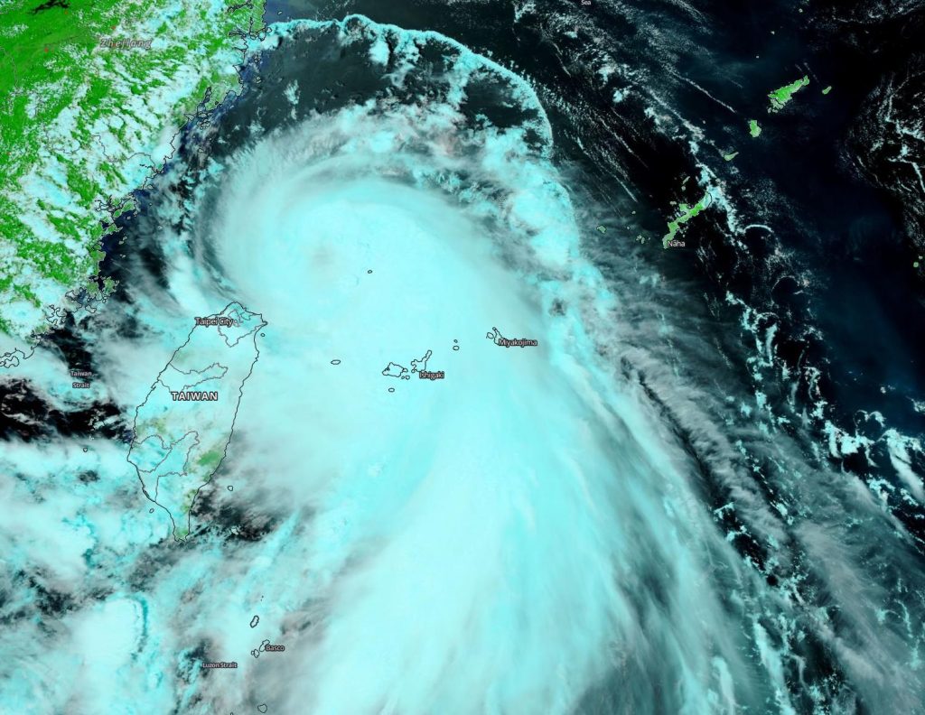
NASA-NOAA’s Suomi NPP satellite provided forecasters with a visible image of Typhoon Hagupit in the Northwestern Pacific Ocean that showed the development of an eye as it quickly intensified. Imagery also showed a thick band of thunderstorms that resembled a giant tail, spiraling into the powerful storm.

Suomi NPP image of Hagupit
NASA-NOAA’s Suomi NPP satellite provided forecasters with a visible image of Typhoon Hagupit on Aug. 3 as it moved through the Northwestern Pacific Ocean, just northeast of Taiwan. Credit: NASA Worldview, Earth Observing System Data and Information System (EOSDIS)

Tropical Depression 03W formed northeast of Luzon, Philippines on August 1 and was renamed Hagupit when it strengthened to a tropical storm on Aug. 2. By Aug. 3, Hagupit had quickly intensified into a typhoon.

On Aug. 3, the Visible Infrared Imaging Radiometer Suite (VIIRS) instrument aboard Suomi NPP revealed that the storm had developed an eye, although it appeared somewhat obscured by high clouds. VIIRS showed that powerful bands of thunderstorms had circled the eye. A large, thick band of thunderstorms that extended south-southeast of the center looked like a giant tail on the VIIRS imagery. Hagupit was northeast of Taiwan at the time Suomi NPP passed overhead.

At 5 a.m. EDT (0900 UTC) on Aug. 3, the Joint Typhoon Warning Center (JTWC) noted that Hagupit had maximum sustained winds near 65 knots (75 mph/120 kph), making it a Category 1 hurricane on the Saffir-Simpson Hurricane Wind Scale. The center of Hagupit was located near latitude 26.8 degrees north and longitude 122.2 degrees east. It was centered about 285 nautical miles west of Kadena Air Base, Okinawa, Japan. Hagupit was moving northwest.

Hagupit is forecast to make landfall later today, Aug. 3, south of Shanghai and curve north then northeast. The center of the storm is expected to pass to the west of Shanghai and then re-emerge into the East China Sea.

NASA Researches Tropical Cyclones

Tropical cyclones/hurricanes are the most powerful weather events on Earth. NASA’s expertise in space and scientific exploration contributes to essential services provided to the American people by other federal agencies, such as hurricane weather forecasting.

For more than five decades, NASA has used the vantage point of space to understand and explore our home planet, improve lives and safeguard our future. NASA brings together technology, science, and unique global Earth observations to provide societal benefits and strengthen our nation. Advancing knowledge of our home planet contributes directly to America’s leadership in space and scientific exploration.

By Rob Gutro 
NASA’s Goddard Space Flight Center