Halong – Northwestern Pacific Ocean

Nov. 08, 2019 – NASA-NOAA Satellite Finds a Weaker, Transitioning Tropical Storm Halong

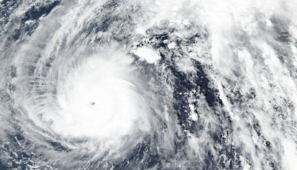
Halong continued to weaken and is transitioning into an extra-tropical cyclone. NASA-NOAA’s Suomi NPP satellite provided a visible image of the less organized storm.

Suomi NPP image of Halong
On Nov. 8, 2019, the VIIRS instrument aboard NASA-NOAA’s Suomi NPP provided a visible image of Tropical Storm Halong in the Northwestern Pacific Ocean as it continued to weaken. Credit: NASA Worldview, Earth Observing System Data and Information System (EOSDIS) / NOAA

The Suomi NPP satellite passed over Halong in the Northwestern Pacific Ocean on Nov. 8. The Visible Infrared Imaging Radiometer Suite (VIIRS) instrument aboard Suomi NPP provided a visible image of the storm that showed it appeared elongated and had a ragged low-level circulation center.

At 10 a.m. EDT (1500 UTC) on Nov. 8, the center of Halong was located near latitude 30.0 degrees north and longitude 160.2 degrees east. Tropical storm Halong’s center was located approximately 419 nautical miles northeast of Minami Tori Shima. Halong’s maximum sustained winds had dropped to 60 knots (69 mph/111 kph). Halong was moving quickly to the east-northeast at 24 knots.

The Joint Typhoon Warning Center or JTWC said that Halong will continue to track northeastward and gradually turn east-northeastward later on Nov. 8. The JTWC noted, “The environment will become more unfavorable with increasing vertical wind shear and cooling sea surface temperatures, leading to rapid weakening. Extra-tropical transition will begin later on Nov. 8 as begins to interact with the baroclinic zone. A baroclinic zone is a region in which a temperature gradient exists on a constant pressure surface.

Suomi NPP captures all three storms
NASA-NOAA’s Suomi NPP satellite provided a panoramic image of 3 tropical cyclones in the northern hemisphere. Cyclone Matmo (left) in the Bay of Bengal, Northern Indian Ocean, Typhoon Nakri (center) in the South China Sea, and Tropical Storm Halong (right) in the Northwestern Pacific Ocean. Credit: NASA Worldview, Earth Observing System Data and Information System (EOSDIS)

When a storm becomes extra-tropical it means that a tropical cyclone has lost its “tropical” characteristics. NOAA’s National Hurricane Center defines “extra-tropical” as a transition that implies both poleward displacement (meaning it moves toward the north or south pole) of the cyclone and the conversion of the cyclone’s primary energy source from the release of latent heat of condensation to baroclinic (the temperature contrast between warm and cold air masses) processes. It is important to note that cyclones can become extratropical and still retain winds of hurricane or tropical storm force.

Hurricanes and typhoons are the most powerful weather event on Earth. NASA’s expertise in space and scientific exploration contributes to essential services provided to the American people by other federal agencies, such as hurricane weather forecasting.

By Rob Gutro 
NASA’s Goddard Space Flight Center

Halong – Northwestern Pacific Ocean

Nov. 07, 2019 – NASA Satellite Imagery Finds Typhoon Halong Resembles a Boxing Glove

Typhoon Halong has packed quite a punch and imagery from NASA’s Terra satellite found that the storm resembled a boxing glove.

Aqua image of Halong
On Nov. 7, the MODIS instrument that flies aboard NASA’s Terra satellite took this image of Typhoon Halong and it resembled a boxing glove from space. Credit: NASA Worldview

On Nov. 7, NASA’s Terra satellite passed over the northwestern Pacific Ocean and the Moderate Resolution Imaging Spectroradiometer or MODIS instrument that flies aboard captured a visible image of Halong. The MODIS image showed powerful thunderstorms circling the center of circulation and a band of thunderstorms northeast of center. Combined, the storm looked like a boxing glove from space with the “thumb” as the band of storms that curved to the east of the center. Satellite imagery using microwaves revealed that there is an eye under that large area of thunderstorms circling the center.

At 10 a.m. EST (1500 UTC) on Nov. 7, the center of Typhoon Halong was located near latitude 24.8 degrees north and longitude 152.2 degrees east. That puts the center about 110 nautical miles west of Minami Tori Shima, Japan. Maximum sustained winds were near 90 knots (104 mph/167 kph).

The Joint Typhoon Warning Center or JTWC noted, “Halong will accelerate poleward [north] while gradually turning northeastward to east-northeastward. The environment will become more unfavorable with increasing vertical wind shear and cooling sea surface temperatures.” That means the storm will experience a weakening trend and after a day, the storm is expected to start transitioning into an extra-tropical storm.

Typhoons and hurricanes are the most powerful weather event on Earth. NASA’s expertise in space and scientific exploration contributes to essential services provided to the American people by other federal agencies, such as hurricane weather forecasting.

By Rob Gutro
NASA’s Goddard Space Flight Center

Halong – Northwestern Pacific Ocean

Nov. 06, 2019 – NASA-NOAA Satellite Finds Super Typhoon Halong Finally Weakening

Super Typhoon Halong has finally peaked in intensity and is now on a weakening trend. NASA-NOAA’s Suomi NPP satellite passed over the Northwestern Pacific Ocean and provided a look at the storm.

Suomi NPP image of Halong
On Nov. 6, 2019, the VIIRS instrument aboard NASA-NOAA’s Suomi NPP provided a visible image of Super Typhoon Halong that showed the storm still maintained an eye and powerful bands of thunderstorms circling it, despite weakening slightly. Credit: NASA Worldview, Earth Observing System Data and Information System (EOSDIS) / NOAA

On Nov. 5, Halong was a powerful Category 5 hurricane on the Saffir-Simpson Hurricane Wind Scale. When the Suomi NPP satellite passed overhead on Nov. 6 the Visible Infrared Imaging Radiometer Suite (VIIRS) instrument aboard provided a visible image of the storm, after it had weakened slightly to a Category 4 storm. The VIIRS imagery showed bands of thunderstorms wrapping into the 10 nautical-mile wide eye.

At 10 a.m. EDT (1500 UTC) on Nov. 6 (or 1 a.m. CHST on Nov. 7) the National Weather Service in Tiyan, Guam noted the eye of Super Typhoon Halong was located near latitude 22.0 degrees north and longitude 150.8 degrees rast. That puts the center of Halong about 255 miles southwest of Minamitorishima, 420 miles northeast of Pagan, 580 miles northeast of Saipan, and 710 miles northeast of Guam.

Halong was moving north-northeast at 6 mph. Halong is expected to maintain this north-northeast heading through Thursday, Nov. 7, with a gradual increase in forward speed. By Saturday, Nov. 9, Halong is forecast to move toward the east-northeast at a faster pace.

Maximum sustained winds have decreased to 155 mph. A Category 4 hurricane contains sustained winds between 130 and 156 mph (113 and 136 knots/209 and 251 kph). Typhoon force winds extend outward from the eye up to 35 miles and tropical storm force winds extend outward up to 145 miles southeast of the center and up to 105 miles elsewhere.

Halong is forecast to weaken further today with a steady weakening trend expected to commence Friday, Nov. 8. On Nov. 8 upper-level winds are forecast to begin to affect the typhoon as Halong moves over cooler sea surface temperatures. Both of those factors are expected to help the storm transition into an extra-tropical cyclone.

Hurricanes are the most powerful weather event on Earth. NASA’s expertise in space and scientific exploration contributes to essential services provided to the American people by other federal agencies, such as hurricane weather forecasting.

For updated forecasts, Visit: https://www.weather.gov/gum/Cyclones

By Rob Gutro 
NASA’s Goddard Space Flight Center

Halong – Northwestern Pacific Ocean

Nov. 05, 2019 – NASA Finds Thick Ring of Powerful Storms around Super Typhoon Halong’s Eye

Typhoon Halong continued to strengthen and has become a super typhoon in the Northwestern Pacific Ocean. Infrared imagery from an instrument aboard NASA’s Terra revealed a thick ring of very high, powerful storms with very cold cloud top temperatures circling the eye.

Terra image of Halong
On Nov. 5 at 6:40 a.m. EST (1140 UTC), the MODIS instrument that flies aboard NASA’s Terra satellite showed a thick band of powerful thunderstorms surrounding Halong’s open eye. Those storms had cloud top temperatures as cold as or colder than (in yellow/light green) minus 80 degrees Fahrenheit (minus 62.2 Celsius). Credit: NASA/NRL

Tropical cyclones are made of up hundreds of thunderstorms, and infrared data can show where the strongest storms are located. They can do that because infrared data provides temperature information, and the strongest thunderstorms that reach highest into the atmosphere have the coldest cloud top temperatures.

On Nov. 5 at 6:40 a.m. EST (1140 UTC), the Moderate Imaging Spectroradiometer or MODIS instrument that flies aboard NASA’s Terra satellite used infrared light to analyze the strength of storms within the tropical cyclone. MODIS found the strongest storms in the very thick and large area of thunderstorms circling Halong’s eight nautical-mile wide eye. Those storms had cloud top temperatures as cold as or colder than minus 80 degrees Fahrenheit (minus 62.2 Celsius). NASA research has found that cloud top temperatures that cold indicate strong storms with the potential to generate heavy rainfall.

On Nov. 5 at 10 a.m. EDT (1500 UTC), Super typhoon Halong had maximum sustained winds near 140 knots (161 mph 259 kph). That makes Halong a powerful Category 5 hurricane on the Saffir-Simpson Hurricane Wind Scale.

Halong was located near latitude 19.9 degrees north and longitude 150.8 degrees east, about 603 nautical miles east-southeast of Iwo To island, Japan. Halong was moving to the northwest.

Forecasters at the Joint Typhoon Warning Center expect Halong will move northwest and then to the north, then northeast. The storm is now at peak intensity and is expected to weaken after today.

Hurricanes are the most powerful weather event on Earth. NASA researches these storms to determine how they rapidly intensify, develop and behave. NASA’s expertise in space and scientific exploration contributes to essential services provided to the American people by other federal agencies, such as hurricane weather forecasting.

By Rob Gutro
NASA’s Goddard Space Flight Center

Halong – Northwestern Pacific Ocean

Nov. 04, 2019 – NASA Provides an Infrared Analysis of Typhoon Halong

Typhoon Halong continued to strengthen in the Northwestern Pacific Ocean as NASA’s Terra satellite passed overhead. Infrared imagery from an instrument aboard Terra revealed very high, powerful storms with very cold cloud top temperatures circling the center as well as in a band of thunderstorms west of the center.

Terra image of Halong
On Nov. 4 at 7:35 a.m. EDT (1235 UTC) the MODIS instrument that flies aboard NASA’s Terra satellite showed areas around Halong’s center as well as in a band of thunderstorms west of the center (in yellow), where cloud top temperatures were as cold as or colder than minus 80 degrees Fahrenheit (minus 62.2 Celsius). Credit: NASA/NRL

Halong developed on Nov. 2 from a low-pressure area designated as System 99W. The storm consolidated into a tropical storm later that day. On Nov. 3, Halong intensified further and became a typhoon.

Tropical cyclones are made of up hundreds of thunderstorms, and infrared data can show where the strongest storms are located. They can do that because infrared data provides temperature information, and the strongest thunderstorms that reach highest into the atmosphere have the coldest cloud top temperatures.

On Nov. 4 at 7:35 a.m. EDT (1235 UTC), the Moderate Imaging Spectroradiometer or MODIS instrument that flies aboard NASA’s Terra satellite used infrared light to analyze the strength of storms within the tropical cyclone. MODIS found those strongest storms  in a very large area circling the center of circulation and in a thick band of storms west of center, where cloud top temperatures were as cold as or colder than minus 80 degrees Fahrenheit (minus 62.2 Celsius). NASA research has found that cloud top temperatures that cold indicate strong storms with the potential to generate heavy rainfall.

On Nov. 4 at 4 a.m. EDT (0900 UTC), Typhoon Halong had maximum sustained winds near 80 knots (92 mph /148 kph). It was located near latitude 17.9 degrees north and longitude 153.1 degrees east, about 381 nautical miles south of Minami Tori Shima, Japan. Halong was moving to the northwest.

Forecasters at the Joint Typhoon Warning Center expect Halong will move northwest, while strengthening further over the open waters of the Northwestern Pacific Ocean. Fortunately, Halong does not pose an immediate threat to land areas.

Hurricanes are the most powerful weather event on Earth. NASA researches these storms to determine how they rapidly intensify, develop and behave. NASA’s expertise in space and scientific exploration contributes to essential services provided to the American people by other federal agencies, such as hurricane weather forecasting.

By Rob Gutro
NASA’s Goddard Space Flight Center