Higos – Northwestern Pacific Ocean

Aug. 19, 2020 – NASA-NOAA’s Suomi NPP Satellite Snaps Tropical Storm Higos’ Landfall

NASA-NOAA’s Suomi NPP satellite provided forecasters with a visible image of the landfall of Tropical Storm Higos on Aug. 18.

Suomi NPP Image of Higos
NASA-NOAA’s Suomi NPP satellite provided forecasters with a visible image of Tropical Storm Higos as it was making landfall in the Guangdong Province of China on Aug. 19 at 0000 UTC (Aug. 18 at 8 p.m. EDT). Credit: NASA Worldview, Earth Observing System Data and Information System (EOSDIS)

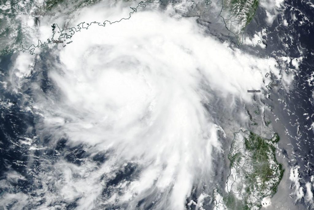
The Visible Infrared Imaging Radiometer Suite (VIIRS) instrument aboard Suomi NPP captured a visible image of Higos as it was making landfall in the Guangdong Province of China on Aug. 19 at 0000 UTC (Aug. 18 at 8 p.m. EDT). Higos came ashore about 18 miles (30 km) south of Macau City. The VIIRS image showed strong thunderstorms wrapped into the center of circulation, and bands of thunderstorms over the South China Sea at the time of the satellite overpass.

On Aug. 19 at 0300 UTC (Aug. 18 at 11 p.m. EDT), Tropical storm Higos had maximum sustained winds near 40 knots (46 mph/74 kph). It was centered about 67 nautical miles west of Hong Kong, China, near latitude 22.3 degrees north and longitude 113.0 degrees east.  Higos was weakening and moving to the northwest.

The Joint Typhoon Warning Center expects Higos to dissipate within a day over China.

NASA Researches Tropical Cyclones

Hurricanes/tropical cylcones are the most powerful weather events on Earth. NASA’s expertise in space and scientific exploration contributes to essential services provided to the American people by other federal agencies, such as hurricane weather forecasting.

For more than five decades, NASA has used the vantage point of space to understand and explore our home planet, improve lives and safeguard our future. NASA brings together technology, science, and unique global Earth observations to provide societal benefits and strengthen our nation. Advancing knowledge of our home planet contributes directly to America’s leadership in space and scientific exploration.

By Rob Gutro 
NASA’s Goddard Space Flight Center

Higos – Northwestern Pacific Ocean

Aug. 18, 2020 – NASA-NOAA Satellite Snaps Image of Tropical Storm Higos in South China Sea

NASA-NOAA’s Suomi NPP satellite passed over the South China Sea and captured a visible image of Tropical Storm Higos. Higos is headed for landfall in southeastern China.

Suomi NPP Image of Higos
NASA-NOAA’s Suomi NPP satellite provided forecasters with a visible image of Tropical Storm Higos in the South China Sea on Aug. 18. Credit: NASA Worldview, Earth Observing System Data and Information System (EOSDIS)

The Visible Infrared Imaging Radiometer Suite (VIIRS) instrument aboard Suomi NPP provided a visible image of Tropical Storm Higos is it moved in a northwesterly direction and toward a landfall in southeastern China. The VIIRS image revealed deep, persistent convection and developing thunderstorms obscuring a low-level circulation center. The VIIRS image also showed there were bands of thunderstorms wrapping around the northern periphery of the system.

At 11 a.m. EDT (1500 UTC), Tropical Storm Higos had maximum sustained winds near 45 knots (52 mph/83 kph). It was located near latitude 21.3 degrees north and longitude 114.3 degrees east, about 82 nautical miles south-southeast of Hong Kong, China.

The Joint Typhoon Warning Center (JTWC) expects Higos to continue moving west-northwest until landfall. Warm sea surface temperatures and low wind shear will fuel intensification so it expected to peak at 50 knot (58 mph/93 kph) sustained winds before landfall, south of Hong Kong. JTWC noted, “After landfall, the rugged terrain of mainland China, in addition to increasing vertical wind shear (outside winds that blow at different levels of the atmosphere that can weaken a storm), will cause the system to begin dissipating over land and rapidly erode the system to full dissipation over land by 36 hours.

For more than five decades, NASA has used the vantage point of space to understand and explore our home planet, improve lives and safeguard our future. NASA brings together technology, science, and unique global Earth observations to provide societal benefits and strengthen our nation. Advancing knowledge of our home planet contributes directly to America’s leadership in space and scientific exploration.

By Rob Gutro 
NASA’s Goddard Space Flight Center