Hikaa – Northern Indian Ocean

Sep. 24, 2019 – Cyclone Hikaa Hits Oman (Earth Observatory update)

A few tropical cyclones spin into the northwestern reaches of the Arabian Sea each, and some bring damaging winds and rain into the Arabian Peninsula. That was the case on September 24, 2019, when Tropical Cyclone Hikaa made landfall over Oman.

Hikaa hitting Oman
NASA Earth Observatory image by Joshua Stevens, using MODIS data from NASA EOSDIS/LANCE and GIBS/Worldvie

The Moderate Resolution Imaging Spectroradiometer (MODIS) on NASA’s Terra satellite acquired this image at 10:45 a.m. Gulf Standard Time (06:45 Universal Time) as the storm’s outer bands moved over Oman. Later that day, the India Meteorological Department reported maximum winds between 120-130 kilometers (75-80 miles) per hour. That’s the equivalent of a category 1 storm on the Saffir-Simpson wind scale.

After encountering the coast of Oman and the dry air over the peninsula, the storm continued moving westward and weakened. Forecasters predicted heavy rainfall in some coastal areas, and officials advised people to stay away from low-lying areas. They also warned that rough seas could be dangerous for fishing boats.

Of all tropical cyclones that occur around the planet each year, only 7 percent are in the North Indian Ocean. They infrequently brush the Arabian Peninsula, and the region can go years without a storm. That said, 2018 brought more storms than usual, with three significant cyclones—Sagar, Mekunu, and Luban—bringing damaging wind and rain to Yemen and Oman. Cyclones tend to occur here in spring and autumn, so the final count for 2019 remains to be seen.

NASA Earth Observatory image by Joshua Stevens, using MODIS data from NASA EOSDIS/LANCE and GIBS/Worldview. Story by Kathryn Hansen.

For additional information and resources visit: https://earthobservatory.nasa.gov/images/145645/cyclone-hikaa-hits-oman?src=eoa-iotd

Hikaa – Northern Indian Ocean

Sep. 24, 2019 – NASA-NOAA Satellite Finds Cyclone Hikaa at Oman’s Coast

NASA-NOAA’s Suomi NPP satellite passed over the Arabian Sea in the Northern Indian Ocean and provided forecasters with a view of Cyclone Hikaa’s structure. Hikaa is at hurricane strength along Oman’s coast.

Suomi NPP image of Hikaa
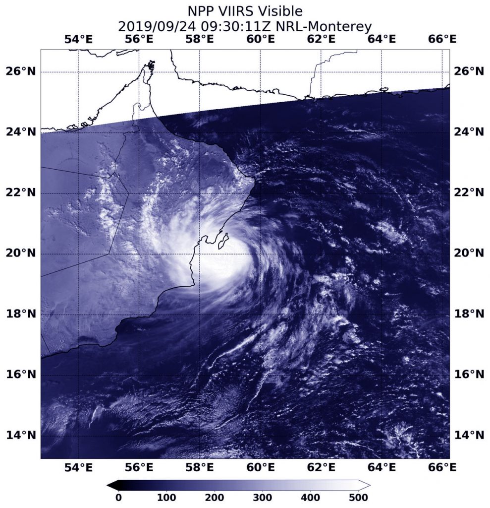
On Sept. 24 at 5:30 a.m. EDT (0930 UTC), NASA-NOAA’s Suomi NPP satellite captured a visible image of Tropical Storm Hikaa along the coast of Oman in the Northern Indian Ocean. Credit: NASA/NOAA/NRL

On Sept. 24 at 5:30 a.m. EDT (0930 UTC), the Visible Infrared Imaging Radiometer Suite (VIIRS) instrument aboard Suomi NPP provided a visible image of Cyclone Hikaa. The VIIRS image showed that the storm was close to the eastern coast of Oman and its center was just south of Masirah Island. Hikaa’s western quadrant was over the coast bringing gusty winds and heavy rainfall.

At 11 a.m. EDT (1500 UTC) on Sept. 24, the center of Cyclone Hikaa was located near latitude 19.9 degrees north and longitude 58.4 degrees east. That puts Hikaa’s center just 38 nautical miles southwest of Masirah Island. Hikaa was moving to the west and maximum sustained winds have increased to near 75 knots (86 mph/139 kph) with higher gusts.

Hikaa is approaching landfall in Oman near Duqm. The storm will dissipate inland.

Hurricanes are the most powerful weather event on Earth. NASA’s expertise in space and scientific exploration contributes to essential services provided to the American people by other federal agencies, such as hurricane weather forecasting.

By Rob Gutro 
NASA’s Goddard Space Flight Center

Hikaa – Northern Indian Ocean

Sep. 23, 2019 – NASA Finds Heavy Rain Potential in Tropical Storm Hikaa

The Northern Indian Ocean has generated a new tropical cyclone. NASA provided an infrared look a recently formed Tropical Storm Hikaa, moving through the Arabian Sea.

Aqua image of Hikaa
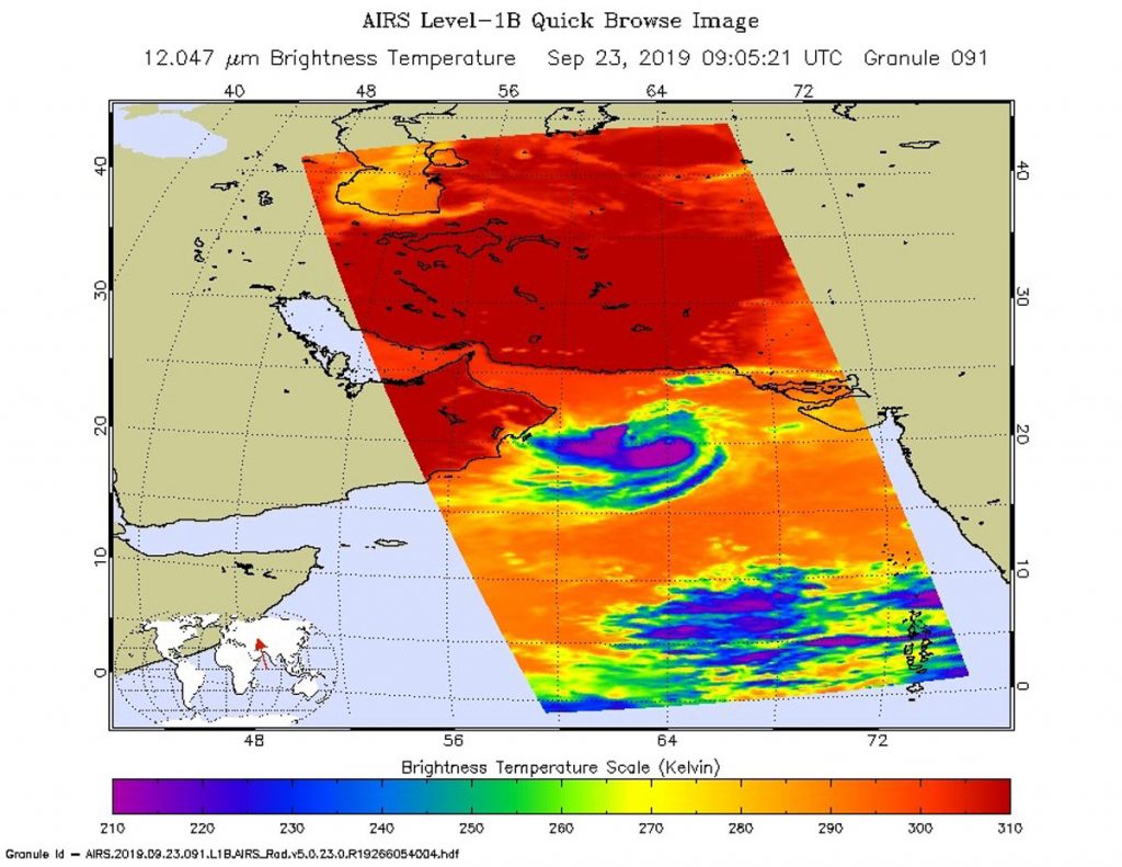
On Sept. 23 at 4:05 a.m. EDT (0905 UTC) NASA’s Aqua satellite analyzed the storm using the Atmospheric Infrared Sounder or AIRS instrument. AIRS found coldest cloud top temperatures as cold as or colder than (purple) minus 63 degrees Fahrenheit (minus 53 degrees Celsius) in a band of thunderstorms west and south around Hikaa’s center. Credit: NASA JPL/Heidar Thrastarson

One of the ways NASA researches tropical cyclones is by using infrared data that provides temperature information. The AIRS instrument aboard NASA’s Aqua satellite captured a look at those temperatures in Hikaa and gave insight into the storm’s rainfall potential. Cloud top temperatures provide information to forecasters about where the strongest storms are located within a tropical cyclone. Tropical cyclones do not always have uniform strength, and some sides have stronger sides than others. The stronger the storms, the higher they extend into the troposphere, and the colder the cloud temperatures are.

NASA provides data to forecasters around the world so they can incorporate that data into their forecasting.

On Sept. 23 at 4:05 a.m. EDT (0905 UTC) NASA’s Aqua satellite analyzed the storm using the Atmospheric Infrared Sounder or AIRS instrument. AIRS found coldest cloud top temperatures as cold as or colder than minus 63 degrees Fahrenheit (minus 53 degrees Celsius) from west to south around Hikaa’s center. NASA research has shown that cloud top temperatures that cold indicate strong storms that have the capability to create heavy rain.

At 11 a.m. EDT (1500 UTC), The Joint Typhoon Warning Center said the center of Tropical Hikaa was located near latitude 20.2 degrees north and longitude 65.5 degrees east. It is located about 265 miles east of Masirah Island, Oman. The tropical storm was moving toward the west. Maximum sustained winds are near 60 knots (69 mph/111 kph) with higher gusts.

Hikaa will strengthen slightly before making landfall in Oman after a day or so.

The AIRS instrument is one of six instruments flying onboard NASA’s Aqua satellite, launched on May 4, 2002.

Hurricanes are the most powerful weather event on Earth. NASA’s expertise in space and scientific exploration contributes to essential services provided to the American people by other federal agencies, such as hurricane weather forecasting.

By Rob Gutro
NASA’s Goddard Space Flight Center