Humberto – Atlantic Ocean

Sep. 20, 2019 – NASA Data Shows Humberto Now Post-Tropical

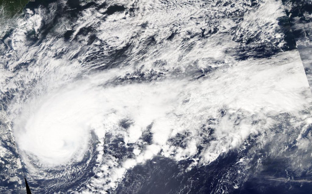
Satellite data has confirmed that Humberto, once a major hurricane is now a post-tropical cyclone. NASA’s Terra Satellite provided a visible image of Post-Tropical Cyclone Humberto as it continued moving in an easterly direction through the North Atlantic Ocean.
Terra image of Humberto
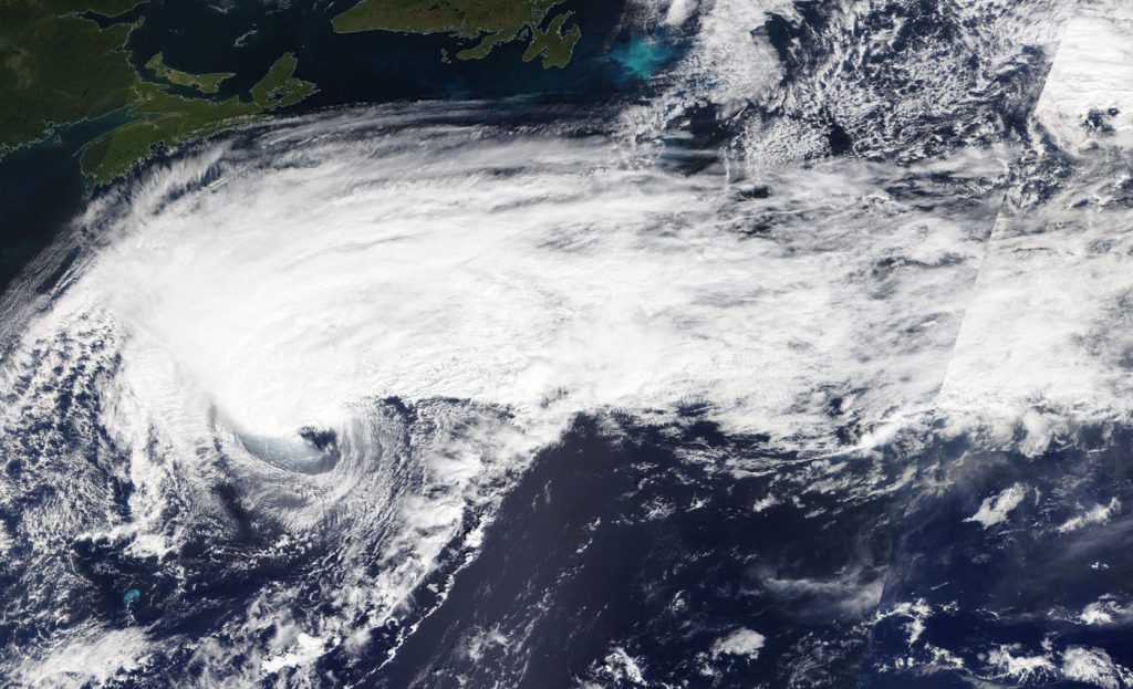
On Sept. 19, the MODIS instrument that flies aboard NASA’s Terra provided a visible image of Post-Tropical Cyclone Humberto moving through the North Atlantic Ocean. Credit: NASA Worldview, Earth Observing System Data and Information System (EOSDIS).

At 11 a.m. EDT on Sept. 19, Humberto was still a powerful hurricane, but the system was in the process of transitioning to an extratropical cyclone. NASA satellite images indicated that frontal features had formed as indicated by its elongated appearance. Cooler and drier air was also wrapping around the western and southern sides of the circulation.

On Sept. 19 at 1:30 p.m. EDT, the Moderate Imaging Spectroradiometer or MODIS instrument that flies aboard NASA’s Terra satellite provided a visible image of Humberto and it was almost a post-tropical cyclone. The image and other satellite images showed a well-defined cold and warm front, but they did not appear to be fully connected to the center of circulation. The MODIS image indicated Humberto was still producing an area of strong thunderstorms northwest of the exposed low-level center.

By 11 p.m. EDT, satellite images showed little strong thunderstorm development, and it was well to the north of the center of the cyclone. Imagery also showed cold air stratocumulus clouds over the western and southern portions. Those cold clouds are indicative of cold air advection (cold air moving in) that is characteristic of an extratropical cyclone. As a result, Humberto was designated post-tropical and the final advisory on the system was issued by the National Hurricane Center.

A Post-Tropical Storm is a generic term for a former tropical cyclone that no longer possesses sufficient tropical characteristics to be considered a tropical cyclone. Former tropical cyclones that have become fully extratropical, subtropical, or remnant lows, are three classes of post-tropical cyclones. In any case, they no longer possesses sufficient tropical characteristics to be considered a tropical cyclone. However, post-tropical cyclones can continue carrying heavy rains and high winds.

At 11 p.m. EDT on Sept. 19 (0300 UTC on Sept. 20), the center of Hurricane Humberto was located near latitude 40.0 degrees north and longitude 58.0 degrees west making the center about 525 nautical miles south-southwest of Cape Race, Newfoundland, Canada. Humberto is moving toward the north-northeast and had maximum sustained winds near 85 knots (98 mph/157 kph).

Humberto is expected to be a large and powerful extratropical cyclone for a couple of days before it is absorbed by another extratropical low-pressure area over the North Atlantic Ocean.

NOAA’s National Hurricane Center noted that large swells would continue to affect Bermuda, the northwestern Bahamas, and the east coast of the United States from east-central Florida to the Mid-Atlantic states during the next couple of days. These swells could create life-threatening surf and rip current conditions.

Hurricanes are the most powerful weather event on Earth. NASA’s expertise in space and scientific exploration contributes to essential services provided to the American people by other federal agencies, such as hurricane weather forecasting.

For updated forecasts, visit: www.nhc.noaa.gov

By Rob Gutro
NASA’s Goddard Space Flight Center

Humberto – Atlantic Ocean

Sep. 19, 2019 – NASA Satellite Data Shows Humberto’s Structure Change

NASA’s Aqua Satellite provided data on Major Hurricane Humberto that revealed its structure was changing as it was moving through the North Atlantic Ocean and past Bermuda.

Aqua image of Humberto
On Sept. 18, the MODIS instrument that flies aboard NASA’s Aqua provided a visible image of Hurricane Humberto north of Bermuda. Powerful thunderstorms circled the center and a large band stretched hundreds of miles east. Aqua cloud height and temperature data revealed Humberto was taking on an extra-tropical hybrid structure. Credit: NASA Worldview, Earth Observing System Data and Information System (EOSDIS).

On Sept. 18 at 12:30 p.m. EDT, the Moderate Imaging Spectroradiometer or MODIS instrument that flies aboard NASA’s Aqua satellite provided visible data on Humberto and measured clouds heights and temperatures that indicated a shift in the storm.

The visible image revealed powerful thunderstorms circled the center and a large band stretched hundreds of miles east. Additional data showed the highest cloud tops, higher than 12,000 meters (7.65 miles) were located mostly south and southwest of the eye, although a small area circled the eye. Those were the most powerful storms within Humberto. Aqua research data also found that cloud top temperatures were as cold as or colder than 200 Kelvin (minus 99.6 degrees Fahrenheit/minus 73.1 degrees Celsius) around in those storms. NASA research has shown that cloud top temperatures that cold have the capability to generate heavy rainfall.

The cloud height and temperature data was provided by NASA’s Worldview product at NASA’s Goddard Space Flight Center, Greenbelt, Md. Hurricanes are the most powerful weather event on Earth. NASA’s expertise in space and scientific exploration contributes to essential services provided to the American people by other federal agencies, such as hurricane weather forecasting.

Hours later, NOAA’s National Hurricane Center or NHC noted at 5 p.m. EDT, “Humberto is taking on more of a hybrid-extratropical structure based on most of the rain shield having been displaced to the left or poleward side of the circulation now as seen in Bermuda weather radar data, and also in conventional and passive microwave satellite imagery.”

On Sept. 19 at 5 a.m. EDT, NHC indicated that Humberto’s extratropical transition continued and that large-scale models, as well as the Florida State University Cyclone Phase Evolution forecast, indicate that the process will be completed in less than 36 hours.

At 11 a.m. EDT (1500 UTC) on Sept. 19, the center of Hurricane Humberto was located near latitude 35.2 degrees north and longitude 62.2 degrees west. Humberto was about 250 miles (400 km) northeast of Bermuda. Humberto is moving toward the northeast near 22 mph (35 kph).  This general motion is expected to continue today, followed by a north-northeastward motion at a slower forward speed Thursday night and Friday. On the forecast track, the center of Humberto will continue to move away from Bermuda.

Maximum sustained winds are near 125 mph (205 kph) with higher gusts.  Humberto is a category 3 hurricane on the Saffir-Simpson Hurricane Wind Scale. Hurricane-force winds extend outward up to 90 miles (150 km) from the center and tropical-storm-force winds extend outward up to 405 miles (650 km). The estimated minimum central pressure is 952 millibars.

On Sept. 19, Humberto was stirring up the seas and creating hazardous conditions.

Large swells and dangerous surf generated by Humberto will continue along the coast of Bermuda through today, and these could continue to cause coastal flooding. Swells will continue to affect the northwestern Bahamas and the southeastern coast of the United States from east-central Florida to North Carolina during the next couple of days.

The hurricane should start to weaken today, and it is expected to become a post-tropical cyclone by Friday.

For updated forecasts, visit: www.nhc.noaa.gov
By Rob Gutro
NASA’s Goddard Space Flight Center

Humberto – Atlantic Ocean

Sep. 18, 2019 – NASA’s Wide View of Major Hurricane Humberto’s Massive Atlantic “Tail”

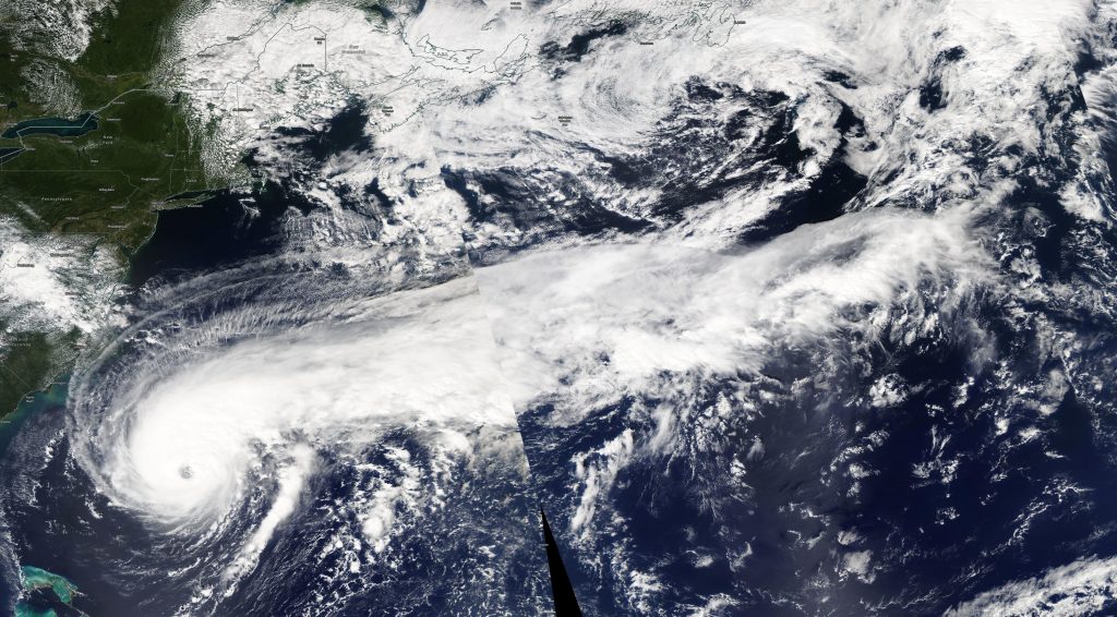
NASA’s Aqua satellite is one in a fleet of NASA satellites that provide data for research. NASA’s Aqua satellite provided a visible image of Major Hurricane Humberto and its very long “tail” of thunderstorms stretching past eastern Canada.

Aqua image of Humberto
On Sept. 18, the MODIS instrument that flies aboard NASA’s Aqua satellite provided these stitched together images of Hurricane Humberto in the Atlantic Ocean. Although Humberto’s eye was just about 490 miles (785 km) west-southwest of Bermuda at the time of the Aqua overpass, the thick band of thunderstorms east of the center stretched beyond eastern Canada! Credit: NASA Worldview

Hurricanes are the most powerful weather event on Earth. NASA’s expertise in space and scientific exploration contributes to essential services provided to the American people by other federal agencies, such as hurricane weather forecasting.

On Sept. 18, the Moderate Imaging Spectroradiometer or MODIS instrument that flies aboard NASA’s Aqua satellite passed over the northern Atlantic Ocean and gathered images of Hurricane Humberto. Humberto is such a large storm that the Aqua satellite had to make two Earth orbits to capture the entire storm. At NASA’s Goddard Space Flight Center in Greenbelt, Maryland, those images were put together to form a complete picture of Humberto.

Although Humberto’s eye was just about 490 miles (785 km) west-southwest of Bermuda at the time of the Aqua overpass, the thick band of thunderstorms east of the center stretched beyond eastern Canada!

On Sept. 19, the National Hurricane Center (NHC) said, “Humberto’s satellite presentation continues to be outstanding with a large ragged eye and surrounded by deep convection.”

The NHC said, “At 8 a.m. EDT (1200 UTC), the eye of Hurricane Humberto was located by satellite near latitude 31.8 degrees north and longitude 68.9 degrees west. Humberto has increased its forward speed and is moving toward the east-northeast near 16 mph (26 kph). This general motion with an additional increase in forward speed is expected through early Thursday, followed by a northeastward to north-northeastward motion through Friday.

Maximum sustained winds are near 115 mph (185 kph) with higher gusts.  Humberto is a category 3 hurricane on the Saffir-Simpson Hurricane Wind Scale.  Some fluctuations in intensity are likely during the next day or so, but Humberto should remain a powerful hurricane through early Thursday.  A steady weakening trend should begin later on Thursday, Sept. 19.

Hurricane-force winds extend outward up to 60 miles (95 km) from the center and tropical-storm-force winds extend outward up to 175 miles (280 km).  The estimated minimum central pressure is 951 millibars.

On the NHC forecast track, the core of Humberto is expected to pass just to the northwest and north of Bermuda later tonight.

For updated forecasts, visit: https://www.nhc.noaa.gov

By Rob Gutro
NASA’s Goddard Space Flight Center

Humberto – Atlantic Ocean

Sep. 17, 2019 – NASA Satellite Provides a View of a Large Hurricane Humberto

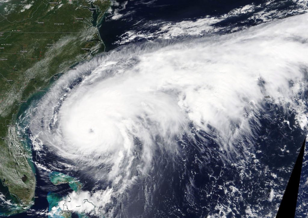
NASA’s Terra Satellite provided a visible image of Hurricane Humberto when it was off the coast of the Carolinas and slowly moving north. The satellite image revealed that Humberto is a large storm.

Terra image of Humberto
On Sept. 15, the MODIS instrument that flies aboard NASA’s Terra provided a visible image of Hurricane Humberto. The storm appears large in the imagery as it stretches from Florida to North Carolina, and has a tail extending to the northeast for hundreds of miles into the western Atlantic Ocean north of Bermuda. In the image, powerful thunderstorms circled the eye, which was also visible. Credit: NASA Worldview, Earth Observing System Data and Information System (EOSDIS).

On Sept. 16, the Moderate Imaging Spectroradiometer or MODIS instrument that flies aboard NASA’s Terra satellite provided a visible image of Hurricane Humberto. The storm appears large in the imagery as it stretches from Florida to North Carolina, and has a tail extending to the northeast for hundreds of miles into the western Atlantic Ocean north of Bermuda. In the image, powerful thunderstorms circled the eye, which was also visible.

Humberto appears to have grown in size, and although it is located off the U.S. East coast, its extent is reaching Bermuda. The National Hurricane Center or NHC issued a Tropical Storm Warning for Bermuda on Sept. 17. Humberto may bring periods of heavy rain to Bermuda beginning Tuesday, with rainfall accumulations of 1 to 3 inches expected. Large swells generated by Humberto will increase along the coast of Bermuda by Wednesday.

NHC said at 8 a.m. EDT (1200 UTC), the large and ragged eye of Hurricane Humberto was located near latitude 30.6 degrees north and longitude 74.0 degrees west. Humberto is moving toward the east-northeast near 8 mph (13 kph).

Data from the Hurricane Hunters aircraft indicate that maximum sustained winds have increased to near 100 mph (160 kph) with higher gusts. Hurricane-force winds extend outward up to 30 miles (45 km) from the center and tropical-storm-force winds extend outward up to 150 miles (240 km).The minimum central pressure recently measured by the reconnaissance aircraft was 961 millibars.

On the forecast track, NHC said the center of Humberto is forecast to approach Bermuda Wednesday night, Sept. 18. NHC forecasters said that strengthening is expected during the next 24 hours, and Humberto could become a major hurricane by late on Sept. 17 or 18.

For updated forecasts, visit: www.nhc.noaa.gov
By Rob Gutro
NASA’s Goddard Space Flight Center

Humberto (Atlantic Ocean)

Sep. 16, 2019 – NASA Finds Humberto Strengthening off the Florida Coast

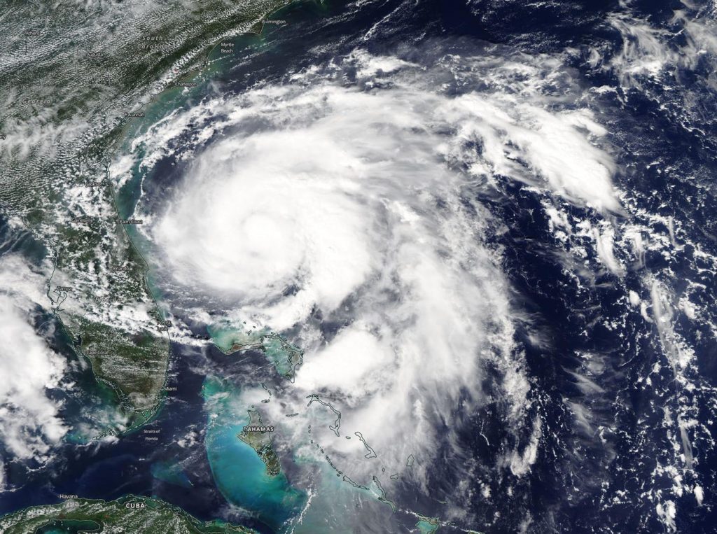
NASA’s Aqua Satellite provided a visible image of Tropical Storm Humberto as it was strengthening off the Florida coast on Sept. 15. Humberto became a hurricane late in the day.

Aqua image of Humberto
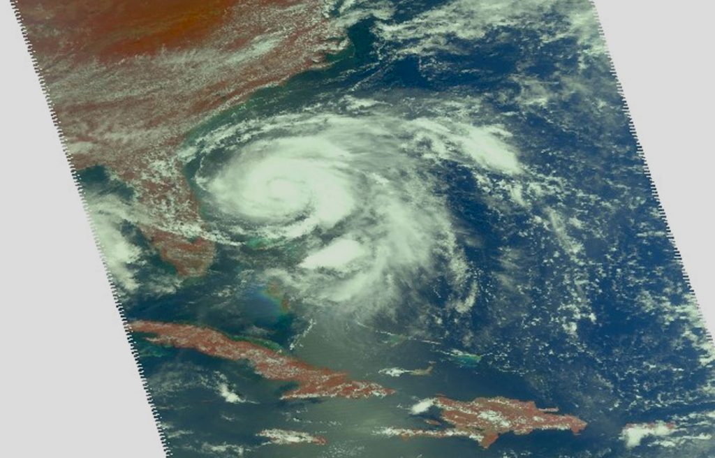
On Sept. 15, the MODIS instrument that flies aboard NASA’s Aqua provided a visible image of Tropical Storm Humberto spinning off the eastern coast of Florida and strengthening. Powerful thunderstorms circled the center and a large band of thunderstorms wrapped into the low-level center from the east. Credit: NASA Worldview, Earth Observing System Data and Information System (EOSDIS).

On Sept. 15, the Moderate Imaging Spectroradiometer or MODIS instrument that flies aboard NASA’s Aqua satellite provided a visible image of Tropical Storm Humberto spinning off the eastern coast of Florida and strengthening. Powerful thunderstorms circled the center and a large band of thunderstorms wrapped into the low-level center from the east. Humberto became a hurricane on Sept. 15 at 11 p.m. EDT.

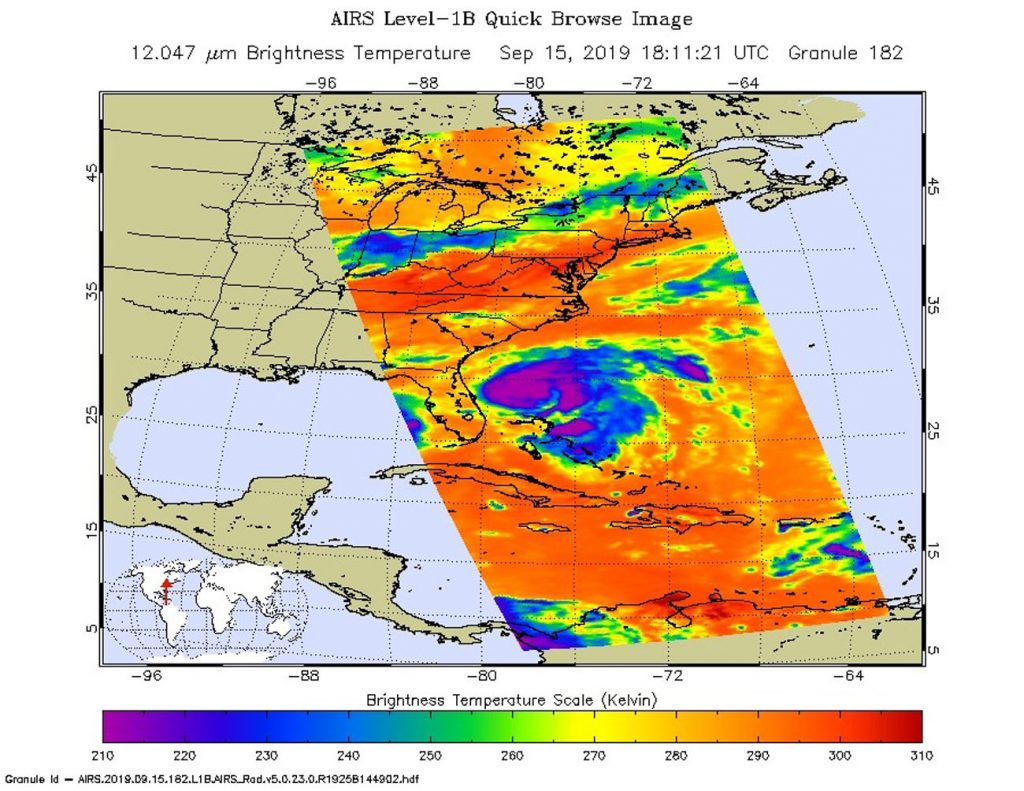
Earlier that day at 2:11 p.m. EDT (1811 UTC) the Atmospheric Infrared Sounder (AIRS) instrument aboard NASA’s Aqua satellite analyzed Humberto’s cloud top temperatures in infrared light. AIRS found coldest cloud top temperatures (purple) of strongest thunderstorms were as cold as or colder than minus 63 degrees Fahrenheit (minus 53 degrees Celsius) around the center. NASA research has shown that storms with cloud top temperatures that cold can produce heavy rainfall.

AIRS infrared image of Humberto
On Sept. 15 at 2:11 p.m. EDT (1811 UTC) the AIRS instrument aboard NASA’s Aqua satellite analyzed Humberto’s cloud top temperatures in infrared light. AIRS found coldest cloud top temperatures (purple) of strongest thunderstorms were as cold as or colder than minus 63 degrees Fahrenheit (minus 53 degrees Celsius) around the center. Credit: NASA JPL/Heidar Thrastarson

On Sept. 16, Humberto was stirring up the seas and creating hazardous conditions. Humberto continued to get better organized to the west of Bermuda and was pushing large swells that were affecting much of the southeastern United States coastline. The National Hurricane Center (NHC) cautioned that interests in and around Bermuda should monitor the progress of Humberto since a Tropical Storm Watch will likely be required for Bermuda later in the day.

At 11 a.m. EDT (1500 UTC), the center of Hurricane Humberto was located near latitude 29.9 degrees north and longitude 76.5 degrees west making the center about 710 miles (1,145 km) west of Bermuda. Humberto is moving toward the east-northeast near 7 mph (11 kph). This general motion with a gradual increase in forward speed is expected through early Thursday.

Near visible Aqua image of Humberto
On Sept. 15 at 2:11 p.m. EDT (1811 UTC) the AIRS instrument aboard NASA’s Aqua satellite provided a near-visible image of Tropical Storm Humberto as it was strengthening into a hurricane. Credit: NASA JPL/Heidar Thrastarson

Data from an Air Force Reserve reconnaissance aircraft indicate that maximum sustained winds are near 85 mph (140 kph) with higher gusts. The minimum central pressure recently measured by reconnaissance aircraft was 978 millibars.

In the NHC discussion, Forecaster Stacy Stewart noted, “Humberto has been strengthening at a rate of 20 knots per 24 hours since this time yesterday, and that trend is expected to continue for the next day or so given the warm water beneath the hurricane and a continued favorable upper-level outflow pattern. The hurricane is expected to peak as a major hurricane in 36 to 48 hours.”

On the forecast track, the center of Humberto is forecast to approach Bermuda Wednesday night, Sept. 18. NHC forecasters said that strengthening is expected during the next 48 hours, and Humberto could become a major hurricane by Tuesday night, Sept. 17.

For updated forecasts, visit: www.nhc.noaa.gov
By Rob Gutro
NASA’s Goddard Space Flight Center

Humberto – Atlantic Ocean

Sep. 13, 2019 – GPM Analyzes Rainfall in Bahamas from Potential Tropical Cyclone 9

As the Bahamas continue to recover from Category 5 hurricane Dorian, a new developing tropical cyclone is bringing additional rainfall to an already soaked area.

GPM image of Potential Tropical Cyclone 9
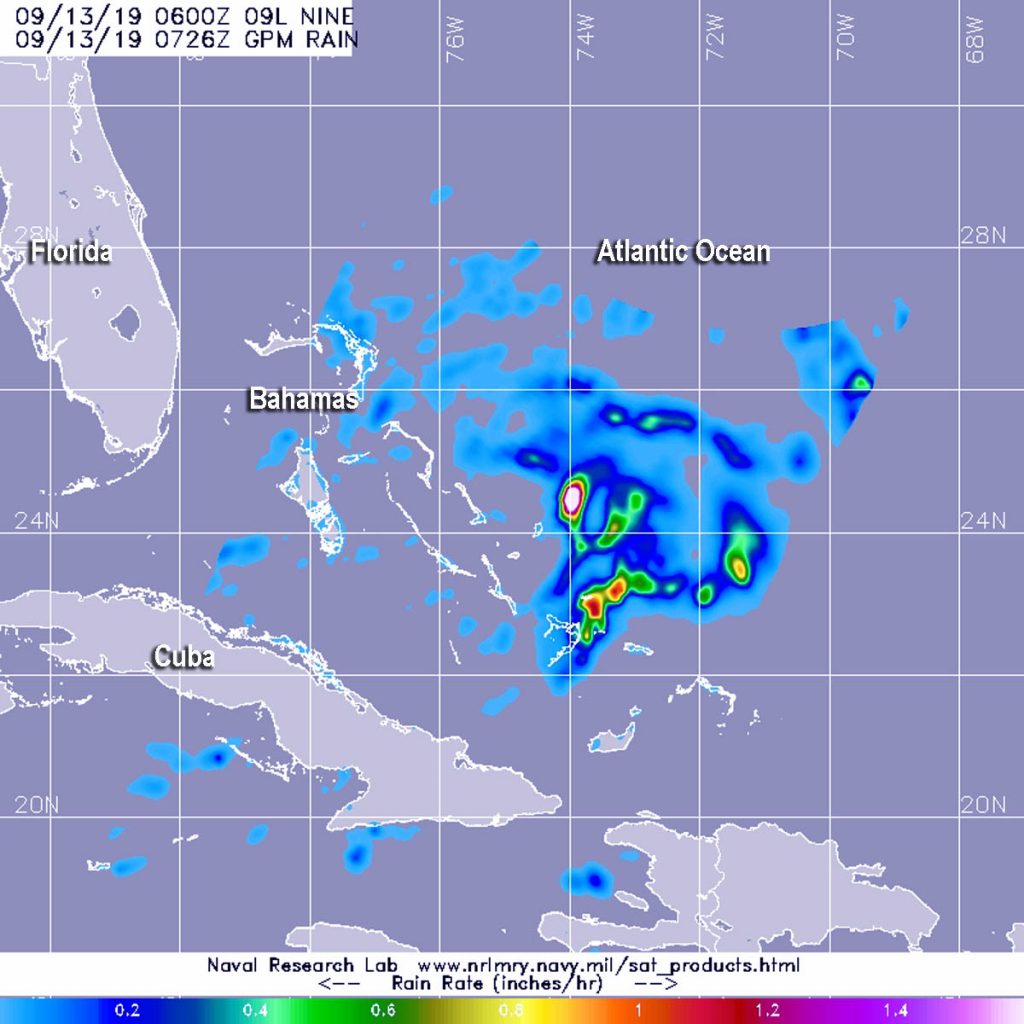
The GPM core satellite passed over developing Potential Tropical Cyclone 9 on Sept. 13 at 2:26 a.m. EDT (0726 UTC). GPM found the heaviest rainfall (pink) northwest of the center where it was falling at a rate of over 40 mm (about 1.6 inch) per hour. Lighter rainfall rates (yellow and blue) were measured throughout the rest of the storm. Credit: NASA/JAXA/NRL

The Global Precipitation Measurement mission or GPM core satellite provided a look at those rainfall rates occurring in Potential Tropical Cyclone Nine, located over the Bahamas.

Potential Tropical Cyclone 9 developed around 5 p.m. EDT on Thursday, Sept. 12. At 11 a.m. EDT on Sept. 13, the depression triggered watches and warnings from NOAA’s National Hurricane Center. A Tropical Storm Warning is in effect for the northwestern Bahamas excluding Andros Island and a Tropical Storm Watch is in effect from Jupiter Inlet to the Flagler-Volusia County line, Fla.

Watches and warnings are already in effect. A Tropical Storm Warning is in effect for the northwestern Bahamas excluding Andros Island and a Tropical Storm Watch is in effect from Jupiter Inlet to Flagler-Volusia County line, Fla.

The GPM or Global Precipitation Measurement mission’s core satellite passed over Tropical Depression 9 on Sept. 13 at 2:26 a.m. EDT (0726 UTC). GPM found the heaviest rainfall northwest of the center where it was falling at a rate of over 40 mm (about 1.6 inch) per hour. GPM is a joint mission between NASA and the Japan Aerospace Exploration Agency, JAXA.

NOAA’s National Hurricane Center noted at 2 p.m. EDT (1800 UTC), the disturbance was centered near latitude 25.4 degrees north and longitude 74.2 degrees west. The system is expected to resume a slow motion toward the northwest and north-northwest later in the day. Maximum sustained winds are near 30 mph (45 kph) with higher gusts. The disturbance is forecast to become a tropical depression or a tropical storm later today or Saturday.

The potential tropical cyclone is expected to produce total rainfall accumulations through Sunday in the Bahamas of up to 2 to 4 inches, with isolated maximum amounts 6 inches. The U.S. Southeast Coast from central Florida into South Carolina can expect from 2 to 4 inches.

On the forecast track, the system is anticipated to move across the central and northwestern Bahamas today, and along or near the east coast of Florida Saturday and Saturday night.

For updated forecasts, visit: www.nhc.noaa.gov
By Rob Gutro
NASA’s Goddard Space Flight Center